Guest, Sign inJoin

Post to Linglestown

We’ll email a one-tap link to publish your post. No password, and nothing is public until you click it.
Already a member? Sign in
–Not graded
History · Linglestown

Linglestown dates to 1765

Most of Linglestown was built recently: 5% of its homes predate 1940 and the median home dates from 1969. Below: 1 old photo or paper, maps from 1892 on, and old-book passages.

1765founded
0on the National Register
5%homes built before 1940
1old photo or paper
1famous people
From Linglestown’s archive · credits on each photo
Quick answers

How Linglestown began

When was Linglestown founded?

1765

Linglestown dates its founding to 1765 (Wikipedia’s history). Its post office opened in 1829.

2020 census: 6,539261 years
Founding year: Wikipedia. First post office: 1829.The full story ↓

What stands out about Linglestown’s past

Read from the archive, the National Register and the record. The page puts what stands out first.

★ What stands out · Help out

Start Linglestown’s collection

The first neighbors to add old photos shape how Linglestown’s history is told.

Decades since 1900 with photos
00s10s20s30s40s50s60s70s80s90s
0 of 10 decades. The empty ones are waiting for someone’s album.
On the map

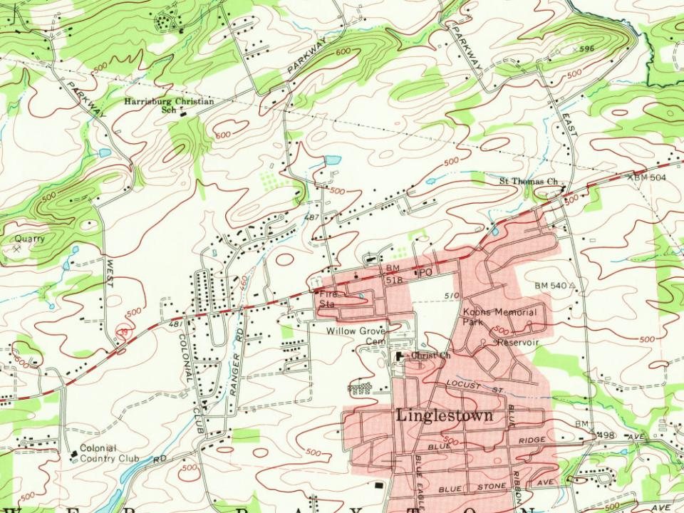
Linglestown on the map, 1892 to 1993

Every edition of the U.S. Geological Survey’s map of Linglestown. Tap a year, or press play to watch the town change.

Linglestown on the 1892 USGS mapLinglestown on the 1924 USGS mapLinglestown on the 1947 USGS mapLinglestown on the 1956 USGS mapLinglestown on the 1969 USGS mapLinglestown on the 1975 USGS mapLinglestown on the 1987 USGS mapLinglestown on the 1993 USGS map1892Harrisburg sheet · 1:62,500

U.S. Geological Survey historical topographic maps (public domain), via Esri’s collection of the scans. The red ring marks the center of Linglestown.

Timeline

Linglestown, 1765 to 1917

Woven from the archive, old maps, post office records, the National Register and the people born here.

  1. 18th century
  2. 1765
    FoundingLinglestown is established
  3. 19th century
  4. 1892On the mapFirst mapped by the U.S. Geological Survey
  5. 20th century
  6. 1917Born hereMiles Zimmerman is born here
The story

How Linglestown came to be

From Wikipedia’s history of Linglestown.

Read it all →

In 1765, Thomas Lingle purchased a parcel of land in what was then Paxton Township, so as to develop a 90-plot living, working, and studying community for newly arriving European settlers. He called his new settlement "The Town of St. Thomas", after the Christian apostle, his namesake. The sheepskin document on which Lingle drew the plan for his village still exists, showing in great detail the village's name, each of the plots, their plot numbers, and all street and alley names. The county deed recorder's seal and record information are visible on the bottom left corner of the document.

Text from Wikipedia, licensed CC BY-SA 4.0.

From the old history books

What they wrote about Linglestown in 1907

Passages that mention Linglestown, cut from the printed page as they were published.

Linglestown was located nine miles from Harrisburg, not far from the base of the First mountain, and six miles from the Susquehanna river. It was laid out by Thomas Lingle in 1765, and called St. Thomas, but afterwards changed to Linglestown. In i860, Dr. C. W. Smith laid out an addition south of t…
History of Dauphin County, Pennsylvania1907 · page 404Read the page →
Read the text

Linglestown was located nine miles from Harrisburg, not far from the base of the First mountain, and six miles from the Susquehanna river. It was laid out by Thomas Lingle in 1765, and called St. Thomas, but afterwards changed to Linglestown. In i860, Dr. C. W. Smith laid out an addition south of the town, which gradually improved. The old tannery of Samuel Mcllhenney wasbuilt there at the beginning of the last century, about 1800.

Text read by machine from the scan; it may contain errors.
Linglestown, in Lower Paxton, at the base of First mountain, was platted by Thomas Lingle, 1765, and called, at first, St. Thomas. It was noted at an early date for the interest its citizens took in free-school matters.
History of Dauphin County, Pennsylvania1907 · page 82Read the page →
Read the text

Linglestown, in Lower Paxton, at the base of First mountain, was platted by Thomas Lingle, 1765, and called, at first, St. Thomas. It was noted at an early date for the interest its citizens took in free-school matters.

Text read by machine from the scan; it may contain errors.

Scans and text from the Internet Archive. Books published in 1930 or earlier, which are in the public domain.

By decade

Linglestown, decade by decade

Then & now

Stand where they stood

No then-and-now pairs yet. Take a photo from the same spot as an old one and they appear here side by side.

Captain James Mackey House
Retake this viewCaptain James Mackey House

Find the spot, match the angle, and add your photo. It becomes the first then-and-now pair on Linglestown’s page.

Retake this view · +15
Stories next door

History across the town line

Each neighbor’s History grade, on the same three inputs.

Questions about Linglestown’s history

What year was Linglestown founded?

In 1765, according to Wikipedia’s history of the town. Linglestown’s post office opened in 1829.

Memory lane

What the archives can’t tell you, neighbors can.

Town Square →
Start a conversation
Sources

Where this page comes from

Founding dates: Wikidata, Wikipedia, the U.S. post office records of Blevins & Helbock (CC0) and the Census. Homes by year built: Census ACS 2020–24. National Register of Historic Places: National Park Service (list of May 22, 2026). Old photos, postcards and papers: Wikimedia Commons, the Library of Congress and other public archives, credited on each item’s page. Maps: U.S. Geological Survey historical topographic maps (via Esri) and Sanborn fire-insurance maps (Library of Congress). History text and census tables: Wikipedia (CC BY-SA 4.0). Places that used to be: USGS Geographic Names Information System (2021). How TownRatings grades history →

From Wikimedia Commons (6), the Library of Congress (1), Wikipedia, Wikidata and Wikipedia for famous people, U.S. Geological Survey historical maps and old county and town histories (Internet Archive). Archive images are copied here with their credits and licenses, shown on each photo’s page. Refreshed monthly.