Founding year: the first Cherokee post office (Blevins & Helbock, CC0).The full story ↓
History grade
What drives Cherokee’s History grade
On its age, its old homes and the National Register, Cherokee is more historic than 81% of U.S. towns. Its share of homes from before 1940 holds the grade up; its age pulls it down.
A−
HistoryA character grade: shown, never part of Cherokee’s overall grade.
Oklahoma towns list more on the Register than most of the country (a typical Oklahoma town has 5.9 per 10,000 residents, the U.S. 2.4), so Cherokee’s 39.8 sits above most of its state (86% of Oklahoma towns have fewer) while its 6 listings outnumber those of 72% of U.S. towns.
How sure. Graded on any two of the three inputs instead, the letter would range from B to A. The pre-1940 share is a Census survey estimate (±7.9 points). The founding year is the first post office, not a stated founding date.
Founding year: the first post office (other dates in Quick answers). Homes: Census ACS 2020–24. National Register: National Park Service, May 2026 list; each listing counted once (boundary changes and added documentation belong to their listing), and a historic district counts its contributing buildings. How TownRatings grades history →
What stands out about Cherokee’s past
Read from the archive, the National Register and the record. The page puts what stands out first.
Peaked at 2,635 in 1950; 1,476 people lived here in 2020.
12 censuses, 1910–2020.
U.S. Census Bureau decennial counts, from the census table on Cherokee’s Wikipedia page.
Every building
Cherokee, building by building, 1902–1920
Fire insurance maps drew every building, what it was made of and what it was used for, so insurers could price the risk of fire. Pick a year, then a sheet.
1902Sheet 1 of 1
Edition
Sheets
BrickWoodStone
Sanborn Map Company, via the Library of Congress. Editions published in 1930 or earlier, which are in the public domain.
After the land opening of 1893, developers wanted to attract railroads to build through the former Cherokee Outlet to transport the large wheat crops to markets. The Kansas and Oklahoma Construction Company, through its subsidiary the Cherokee Investment Company, bought 100 acres (40 ha) along its route, platted the town which it named Cherokee, and held a sale of lots on February 9, 1901. Cherokee officially incorporated in July 1901. Two years later, the Kansas City, Mexico and Orient Railroad (later owned by the Atchison, Topeka and Santa Fe Railway) constructed a line through Cherokee. To gain access to the railroad, residents of the nearby community of Erwin, which already had a post office by that name, relocated to Cherokee. Erwin then ceased to exist and Cherokee took its place. This post office was renamed "Cherokee" in March, 1903.
Passages that mention Cherokee, cut from the printed page as they were published.
History of the Cherokee Indians and their legends and folk lore1921 · page 252Read the page →
Read the text
Reverend Worcester procured another press and full complement of Cherokee type and emigrated with them to the Western Cherokee Nation where he first stopped at Dwight and then proceeded to Union Mission, on Grand River, arriving there in the fall of 1835 and set up his press from which he published several religious works both in the Choctaw and Cherokee languages, notably the Cherokee Almanac for the year of 1836. These publications were the pioneers of Oklahoma printing. As he moved to Park Hill on December 2, 1836, it is possible that no Almanac was published for the
Text read by machine from the scan; it may contain errors.
History of the Cherokee Indians and their legends and folk lore1921 · page 133Read the page →
Read the text
At a sjeneral convention of the people of the Cherokee Nation, held at Tahlequah, Cherokee Nation, on the 2Sth day of November, A. D. 1866. for the purpose of taking- Into consideration the foregoing amendments to the Constitution of the Cherokee Nation; and, whereof, Riley Keys, Chief Justice of the Supreme Court, was chosen President, and Budd Gritts, Secretary; the said amendments to the Constitution of the Cherokee Nation were read, considered and severally approved and adopted by the Cherokee people.
Text read by machine from the scan; it may contain errors.
Scans and text from the Internet Archive. Books published in 1930 or earlier, which are in the public domain.
Timeline
Cherokee, 1894 to 1980
Woven from the archive, old maps, post office records, the National Register and the people born here.
Nothing in the archives for these yearsWeddings on Main Street, storms, parades, school pictures, the old store. If it’s in your family album, it belongs here.
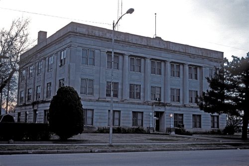
National Park Service, National Register of Historic Places. Photos from Wikimedia Commons, credited on each place’s page.
Questions about Cherokee’s history
What year was Cherokee founded?
The Cherokee post office opened in 1894, the earliest record of the town by name (U.S. post office records).
How does Cherokee rank for history?
Cherokee is more historic than 81% of U.S. towns. The History grade combines the town’s founding era, the share of homes built before 1940 and its National Register listings. It’s a character grade, so it isn’t part of the overall grade. How it works.
What is on the National Register in Cherokee?
6 listings: 5 buildings and 1 structure.
How old are the homes in Cherokee?
37% of Cherokee’s homes were built before 1940 (Census estimate, ±7.9 points), against a typical 7.0% for an Oklahoma town; the median home was built in 1949.
Founding dates: Wikidata, Wikipedia, the U.S. post office records of Blevins & Helbock (CC0) and the Census. Homes by year built: Census ACS 2020–24. National Register of Historic Places: National Park Service (list of May 22, 2026). Old photos, postcards and papers: Wikimedia Commons, the Library of Congress and other public archives, credited on each item’s page. Maps: U.S. Geological Survey historical topographic maps (via Esri) and Sanborn fire-insurance maps (Library of Congress). History text and census tables: Wikipedia (CC BY-SA 4.0). Places that used to be: USGS Geographic Names Information System (2021).
From Wikimedia Commons (2), the National Register of Historic Places (6), Wikipedia, U.S. Geological Survey historical maps, U.S. Census counts (via Wikipedia), the US Post Offices dataset (Blevins & Helbock), the USGS Geographic Names Information System, Sanborn fire insurance maps (Library of Congress) and old county and town histories (Internet Archive). Archive images are copied here with their credits and licenses, shown on each photo’s page. Refreshed monthly.




 2014


