Afton’s post office opened in 1886, and 2 of its places are on the National Register
Most of Afton was built recently: 9% of its homes predate 1940 and the median home dates from 1972. Its Register listings are the Horse Creek Bridge and the Cities Service Station. Below: 7 old photos and papers, maps from 1894 on, and the census since 1900.
Fire insurance maps drew every building, what it was made of and what it was used for, so insurers could price the risk of fire. Pick a year, then a sheet.
1894Sheet 1 of 1
Edition
Sheets
BrickWoodStone
Sanborn Map Company, via the Library of Congress. Editions published in 1930 or earlier, which are in the public domain.
People over time
Afton, census by census
Peaked at 1,518 in 1920; 734 people lived here in 2020.
13 censuses, 1900–2020.
U.S. Census Bureau decennial counts, from the census table on Afton’s Wikipedia page.
On the map
Afton on the map, 1907 to 1986
Every edition of the U.S. Geological Survey’s map of Afton. Tap a year, or press play to watch the town change.
1907Wyandotte sheet · 1:125,000
U.S. Geological Survey historical topographic maps (public domain), via Esri’s collection of the scans. The red ring marks the center of Afton.
Afton developed in this part of the Cherokee Nation in Indian Territory after the Atlantic and Pacific Railroad (later the St. Louis and San Francisco Railway, or Frisco) built tracks through the area to Vinita in 1871. Regarding the town name, Oklahoma historian George Shirk states that a Scottish railroad surveyor, Anton Aires, named the town Afton after his daughter, while others have claimed the name comes from Robert Burns's poem, "Flow Gently Sweet Afton." In either case, Afton Aires' name and the Burns poem honor the River Afton in Scotland.
Nothing in the archives for these yearsWeddings on Main Street, storms, parades, school pictures, the old store. If it’s in your family album, it belongs here.
Founding dates: Wikidata, Wikipedia, the U.S. post office records of Blevins & Helbock (CC0) and the Census. Homes by year built: Census ACS 2020–24. National Register of Historic Places: National Park Service (list of May 22, 2026). Old photos, postcards and papers: Wikimedia Commons, the Library of Congress and other public archives, credited on each item’s page. Maps: U.S. Geological Survey historical topographic maps (via Esri) and Sanborn fire-insurance maps (Library of Congress). History text and census tables: Wikipedia (CC BY-SA 4.0). Places that used to be: USGS Geographic Names Information System (2021). How TownRatings grades history →
From Wikimedia Commons (16), Wikidata (1), the National Register of Historic Places (2), Wikipedia, U.S. Geological Survey historical maps, U.S. Census counts (via Wikipedia), the US Post Offices dataset (Blevins & Helbock), the USGS Geographic Names Information System and Sanborn fire insurance maps (Library of Congress). Archive images are copied here with their credits and licenses, shown on each photo’s page. Refreshed monthly.


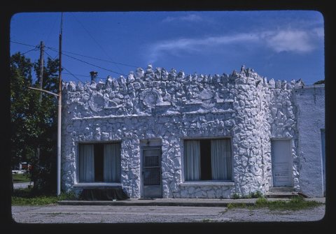
 1982
 1982
 Date?
 Date?
 Date?
 Date?
 2026
 2026
 2016
 2016
 2010
 2010
 2010
 2008
 2008


