Founding year: Wikidata; Wikipedia’s history section gives the same year. First post office: 1854.The full story ↓
History grade
What drives Wauseon’s History grade
On its age, its old homes and the National Register, Wauseon is more historic than 70% of U.S. towns, #429 of 993 in Ohio. Its share of homes from before 1940 holds the grade up; its age pulls it down.
B+
HistoryA character grade: shown, never part of Wauseon’s overall grade.
Ohio towns list about as much on the Register as the country (a typical Ohio town has 2.9 per 10,000 residents, the U.S. 2.4), so Wauseon’s 8.0 sits above most of its state (71% of Ohio towns have fewer) while its 6 historic buildings outnumber those of 72% of U.S. towns.
How sure. Graded on any two of the three inputs instead, the letter would range from B to A−. The pre-1940 share is a Census survey estimate (±5.5 points). Two sources give 1853.
Founding year: Wikidata (other dates in Quick answers). Homes: Census ACS 2020–24. National Register: National Park Service, May 2026 list; each listing counted once (boundary changes and added documentation belong to their listing), and a historic district counts its contributing buildings. How TownRatings grades history →
What stands out about Wauseon’s past
Read from the archive, the National Register and the record. The page puts what stands out first.
Fire insurance maps drew every building, what it was made of and what it was used for, so insurers could price the risk of fire. Pick a year, then a sheet.
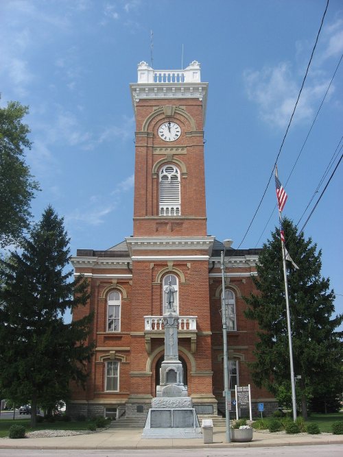
Wauseon was platted in 1853 when the Michigan Southern Air Railway was extended to that point. Land speculators bought 160 acres of land that would become the city of Wauseon. The original name for the city was "Litchfield" after Litchfield, New York, birthplace of many of the city's settlers. Hortensia Hayes, the daughter of an early settler, suggested that the new village be named after an Ottawa tribe chief named Wauseon, who had been forced in 1839 by the federal government to forfeit the tribe's land and move to Oklahoma. The village was incorporated in 1859. With the commercial success that the railroad brought, Wauseon grew larger than Fulton County's original seat of Ottokee, and in 1869, Wauseon was named the county seat. The Fulton County Courthouse was built in 1871.
Passages that mention Wauseon, cut from the printed page as they were published.
A standard history of Fulton County, Ohio, an authentic narrative of the past, with an extended survey of modern developments in the progress of town and county1920 · page 253Read the page →
Read the text
Transportation Facilities Wauseon has three steam railway systems passing through it, and one electrified railway, so that, in case industrial development begins in earnest, it will be possible to readily obtain railroad facilities to cope with such advancement. An article written in 1906, on “Wauseon, a railroad centre,” gives a good review of the somewhat encouraging position of Wauseon, in this respect, describing Wauseon as “where the railways meet.” In part, the article stated:
Text read by machine from the scan; it may contain errors.
A standard history of Fulton County, Ohio, an authentic narrative of the past, with an extended survey of modern developments in the progress of town and county1920 · page 221Read the page →
Read the text
than one person. On July 16, 1870, an ordinance “for the appointment of a police for the village” was read for the first time, and at that meeting the following resolution was unanimously passed: “Resolved: By the Council of the Incorporated Village of Wauseon, Ohio, that the resignation of Orrin Buzzell, as marshal of said village, will be accepted by said Council, if tendered.” The ordinance provided for a police force, “not to exceed three in number, one of whom shall be designated to act as Chief of Police.” The measure was; passed, but sub-
Text read by machine from the scan; it may contain errors.
Observations were made one mile north of Wauseon, Ohio, till March 1, 1902, and since then in Wauseon, just one mile south of the old station. The old station was in north latitude 41 degrees and 36 minutes, and west longitude 84 degrees and seven minutes, 152 Digitized by v^ooQle
Text read by machine from the scan; it may contain errors.
Scans and text from the Internet Archive. Books published in 1930 or earlier, which are in the public domain.
Timeline
Wauseon, 1853 to 1934
Woven from the archive, old maps, post office records, the National Register and the people born here.
Nothing in the archives for these yearsWeddings on Main Street, storms, parades, school pictures, the old store. If it’s in your family album, it belongs here.
In 1853, according to Wikidata and Wikipedia’s history of the town. Wauseon’s post office opened in 1854, and the census of 1860 counted 378 people here.
How does Wauseon rank for history?
Wauseon is more historic than 70% of U.S. towns, #429 of 993 in Ohio. The History grade combines the town’s founding era, the share of homes built before 1940 and its National Register listings. It’s a character grade, so it isn’t part of the overall grade. How it works.
What is on the National Register in Wauseon?
4 listings: 4 buildings, among them the Fulton County Courthouse (listed 1973, the first). 6 historic buildings in all.
How old are the homes in Wauseon?
23% of Wauseon’s homes were built before 1940 (Census estimate, ±5.5 points), against a typical 15% for an Ohio town; the median home was built in 1972.
Founding dates: Wikidata, Wikipedia, the U.S. post office records of Blevins & Helbock (CC0) and the Census. Homes by year built: Census ACS 2020–24. National Register of Historic Places: National Park Service (list of May 22, 2026). Old photos, postcards and papers: Wikimedia Commons, the Library of Congress and other public archives, credited on each item’s page. Maps: U.S. Geological Survey historical topographic maps (via Esri) and Sanborn fire-insurance maps (Library of Congress). History text and census tables: Wikipedia (CC BY-SA 4.0). Places that used to be: USGS Geographic Names Information System (2021).
From Wikimedia Commons (6), the National Register of Historic Places (4), Wikipedia, Wikidata and Wikipedia for famous people, U.S. Geological Survey historical maps, U.S. Census counts (via Wikipedia), the US Post Offices dataset (Blevins & Helbock), the USGS Geographic Names Information System, Sanborn fire insurance maps (Library of Congress) and old county and town histories (Internet Archive). Archive images are copied here with their credits and licenses, shown on each photo’s page. Refreshed monthly.




 1907
 1909
 1909
 1909
 1909
