
The story
Read it all →How Polk came to be
From Wikipedia’s history of Polk.
Polk was laid out in 1849. A post office called Polk has been in operation since 1846.
Text from Wikipedia, licensed CC BY-SA 4.0.
Each edition grades its towns against each other only.
Below: maps from 1906 on and the census since 1880.
The Polk post office opened in 1846, the earliest record of the town by name. Wikidata gives 1849.
Read from the archive, the National Register and the record. The page puts what stands out first.
The first neighbors to add old photos shape how Polk’s history is told.
From Wikipedia’s history of Polk.
Polk was laid out in 1849. A post office called Polk has been in operation since 1846.
Text from Wikipedia, licensed CC BY-SA 4.0.
Peaked at 435 in 1970; 310 people lived here in 2020.
15 censuses, 1880–2020.
U.S. Census Bureau decennial counts, from the census table on Polk’s Wikipedia page.
Passages that mention Polk, cut from the printed page as they were published.

The German Reformed and Lutherans built a church on the present site of the village of Polk, in Jackson township, in 1830. A small congregation organized in 1827. In 1840-41, the members of Orange township withdrew, and those remaining in Jackson town erected a new church, thirty-five by forty met, half a mile west of Perrysburgh. It has about seventy-five members.
Text read by machine from the scan; it may contain errors.
of Ashland.) In 1824 Mr. Bryan removed his family to the southeast quarter of section 18, Jackson Town* ship — being the same land upon which now stands the greater part of the town of Polk. Mr. Bryan died on the 7th of February, 1848, at the age of seventy years.
Text read by machine from the scan; it may contain errors.
The Polk Methodist Episcopal church was organized some time prior to 1 83 9, as a class. In that year a church was built. The congregation, at that, time, belonged to the Ashland circuit. Its leading members were the Bryans, Chilcotes, Richards, Proudfits, Ruffeurns, Gordons and Barracks. It has now about sixtyfive members.
Text read by machine from the scan; it may contain errors.
Harrison H. Owens obtained his education in the schools of Polk and when a little lad witnessed the erection of the first house in the village, the surrounding country being largely covered with timber. In early manhood he became identified with business pursuits as a carpenter and farmer and his efforts have been no unimportant factor in the work of development and improvement that has transformed this region from a wilderness into one of fertile fields and thriving
Text read by machine from the scan; it may contain errors.Scans and text from the Internet Archive. Books published in 1930 or earlier, which are in the public domain.
Woven from the archive, old maps, post office records, the National Register and the people born here.
Every edition of the U.S. Geological Survey’s map of Polk. Tap a year, or press play to watch the town change.
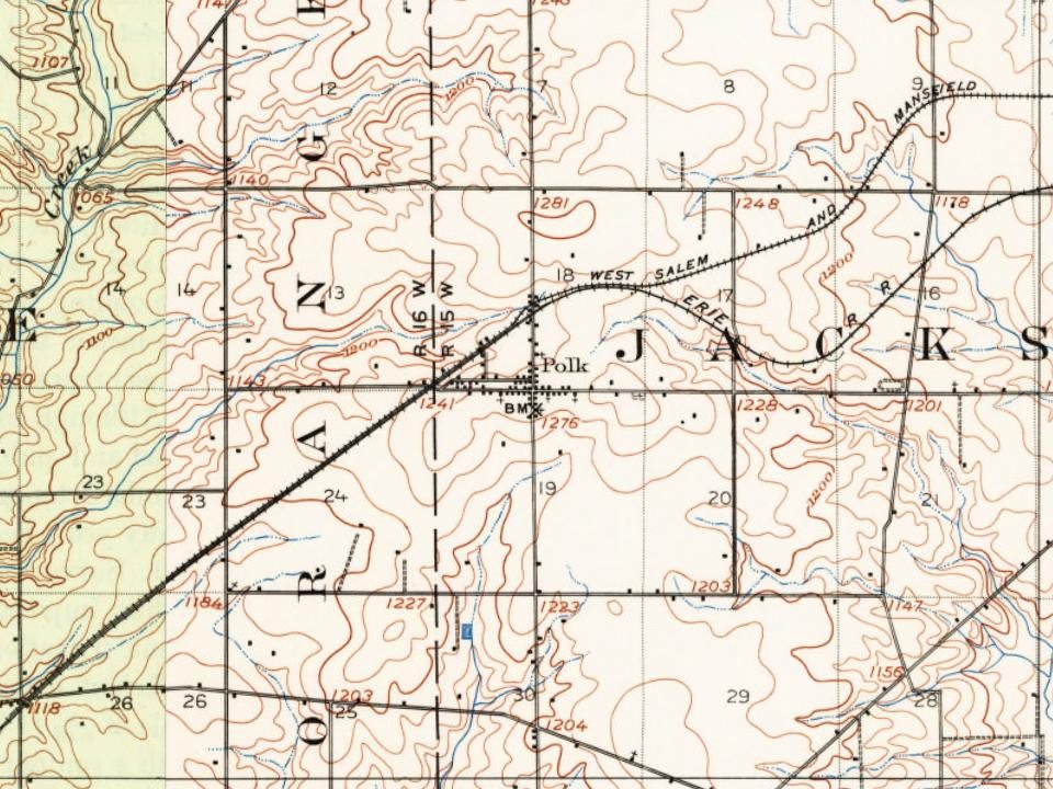
U.S. Geological Survey historical topographic maps (public domain), via Esri’s collection of the scans. The red ring marks the center of Polk.
Writers, athletes, leaders and more, ranked by how widely they’re known.
The Polk post office opened in 1846, the earliest record of the town by name (U.S. post office records). Wikidata gives 1849.
What the archives can’t tell you, neighbors can.
Founding dates: Wikidata, Wikipedia, the U.S. post office records of Blevins & Helbock (CC0) and the Census. Homes by year built: Census ACS 2020–24. National Register of Historic Places: National Park Service (list of May 22, 2026). Old photos, postcards and papers: Wikimedia Commons, the Library of Congress and other public archives, credited on each item’s page. Maps: U.S. Geological Survey historical topographic maps (via Esri) and Sanborn fire-insurance maps (Library of Congress). History text and census tables: Wikipedia (CC BY-SA 4.0). Places that used to be: USGS Geographic Names Information System (2021). How TownRatings grades history →
From Wikimedia Commons (6), Wikipedia, Wikidata and Wikipedia for famous people, U.S. Geological Survey historical maps, U.S. Census counts (via Wikipedia), the US Post Offices dataset (Blevins & Helbock), the USGS Geographic Names Information System and old county and town histories (Internet Archive). Archive images are copied here with their credits and licenses, shown on each photo’s page. Refreshed monthly.


 2016
 2016
 2016
 2016
 2015
 2004

