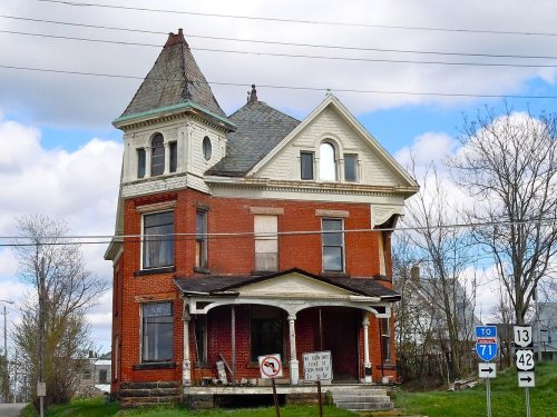
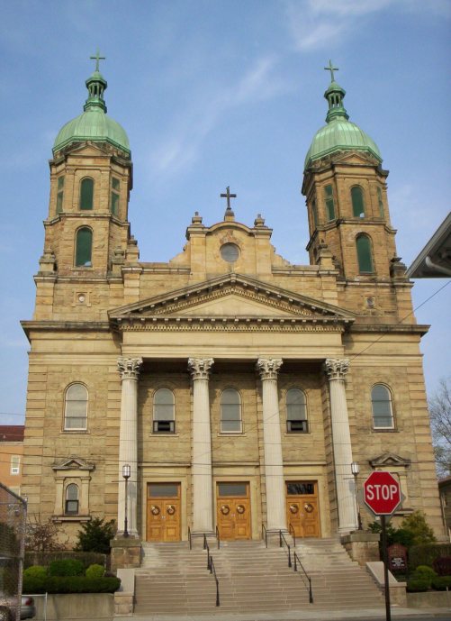
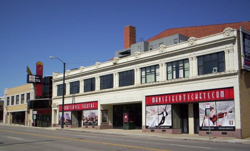
Mansfield dates to 1808, and 25% of its homes were built before 1940
More historic than 93% of U.S. towns · #104 of 993 in Ohio. What drives it
51 places in town are on the National Register, among them three historic districts with 105 buildings between them. Below: maps from 1887 on and the census since 1820.
Founding year: Wikidata; Wikipedia’s history section gives the same year. First post office: 1811. Name: Wikipedia, licensed CC BY-SA 4.0.The full story ↓
History grade
What drives Mansfield’s History grade
On its age, its old homes and the National Register, Mansfield is more historic than 93% of U.S. towns, #104 of 993 in Ohio. All 3 inputs are above most U.S. towns; its National Register listings ranks highest and its age lowest.
A
HistoryA character grade: shown, never part of Mansfield’s overall grade.
Ohio towns list about as much on the Register as the country (a typical Ohio town has 2.9 per 10,000 residents, the U.S. 2.4), so Mansfield’s 35.7 sits above most of its state (86% of Ohio towns have fewer) while its 170 historic buildings outnumber those of 92% of U.S. towns.
How sure. Graded on any two of the three inputs instead, the letter would range from A− to A. The pre-1940 share (±2.1 points) is firm at this size. Two sources give 1808.
Founding year: Wikidata (other dates in Quick answers). Homes: Census ACS 2020–24. National Register: National Park Service, May 2026 list; each listing counted once (boundary changes and added documentation belong to their listing), and a historic district counts its contributing buildings. How TownRatings grades history →
What stands out about Mansfield’s past
Read from the archive, the National Register and the record. The page puts what stands out first.
Mansfield was laid out and founded by James Hedges, Joseph Larwell, and Jacob Newman, and was platted in June 1808 as a settlement. It was named for Colonel Jared Mansfield, the United States Surveyor General who directed its planning.
Passages that mention Mansfield, cut from the printed page as they were published.
History of Richland County, Ohio1880 · page 311Read the page →
Read the text
The Mansfield, Coldwater & Lake Michigan Railroad Compau}-, the fourth and last, to date, of the railroads passing through or entering Mansfield, filed its certificate of incorporation with the Secretary of State May 20, 1870, to build a railroad from Mansfield to a point on the State line lietween Ohio and Michigan, eighteen miles from the northwest corner of
Text read by machine from the scan; it may contain errors.
A centennial biographical history of Richland county, Ohio1901 · page 37Read the page →
Read the text
One of the highest points in the state being at the Settlement church, five miles south of Mansfield, where the elevation is about one thousand feet above Lake Erie. The Settlement church has an elevation of 370 feet above the city of Mansfield. The elevation of Mansfield above Lake Erie is differently given by the several railroads passing through the city. The profile of the Baltimore & Ohio gives the eleation as 657 feet; the Pittsburg, Fort Wayne & Chicago, 592 feet; the Erie, 581. The calculations were taken from different locations about the city. It is a safe estimate to give the elevation of
Text read by machine from the scan; it may contain errors.
History of Richland County, Ohio1880 · page 304Read the page →
Read the text
one of the oldest railroads in Ohio. The history of the State, in preceding pages, gives an account of the growth of early railways, mentioning the Sandusky. Mansfield & Newark (now a part of the Baltimore & Ohio) Railroad. That portion of this road 1}' ing in this county was chartered March 12, 1836, as the Mansfield & New Haven Railroad, and extended from
Text read by machine from the scan; it may contain errors.
History of Richland County, Ohio, from 1808 to 1908. Also biographical sketches of prominent citizens of the county1908 · page 1031Read the page →
Read the text
Lewis Brucker, an attorney of Mansfield, was bom neai the village of Bridgeport, in Saginaw county, Michigan, October 30, 1855. He was graduated at the Ann Arbor Law School, at Ann Arbor, Michigan, in March, 1881, and has engaged in the practice of law in the city of Mansfield since March 1, 1886.
Text read by machine from the scan; it may contain errors.
Scans and text from the Internet Archive. Books published in 1930 or earlier, which are in the public domain.
Timeline
Mansfield, 1808 to 1974
Woven from the archive, old maps, post office records, the National Register and the people born here.
Every edition of the U.S. Geological Survey’s map of Mansfield. Tap a year, or press play to watch the town change.
1960Mansfield North sheet · 1:24,000
U.S. Geological Survey historical topographic maps (public domain), via Esri’s collection of the scans. The red ring marks the center of Mansfield.
Every building
Mansfield, building by building, 1887–1921
Fire insurance maps drew every building, what it was made of and what it was used for, so insurers could price the risk of fire. Pick a year, then a sheet.
Dale Avenue Mobile Home ParkGreenfield Estates Mobile Home ParkKen-mar Mobile Home ParkLincoln HeightsMidpoint WoodsSouth BoulevardsSpring GroveSunnyviewWoodside Estates Mobile Home Park
Gone or out of use
Calvary Bible ChurchchurchChapelwood Covenant ChurchchurchChurch of ChristchurchChurch of GodchurchChurch of God in ChristchurchDiamond Hill ChapelchurchFirst Evangelical United Brethren ChurchchurchMarion Avenue SchoolschoolMayflower Memorial Congregational ChurchchurchMount Zion Israel of God ChurchchurchPeoples HospitalhospitalRichland HospitalhospitalSandy Hill SchoolschoolSchool Number 2schoolSchool Number 4schoolSchool Number 8schoolWest First Street Schoolschool
4cemeteries and burying grounds inside Mansfield
Mansfield CityOhio State ReformatoryPainterZeiter
US Post Offices dataset (Blevins & Helbock, CC0). Places and cemeteries from the USGS Geographic Names Information System (2021).
Stories next door
History across the town line
Each neighbor’s History grade, on the same three inputs.
In 1808, according to Wikidata and Wikipedia’s history of the town. Mansfield’s post office opened in 1811, and the census of 1820 counted 288 people here.
How does Mansfield rank for history?
Mansfield is more historic than 93% of U.S. towns, #104 of 993 in Ohio. The History grade combines the town’s founding era, the share of homes built before 1940 and its National Register listings. It’s a character grade, so it isn’t part of the overall grade. How it works.
What is on the National Register in Mansfield?
51 listings: 45 buildings, among them the Oak Hill Cottage (listed 1969, the first), 3 historic districts, the Kingwood Center, the Raemelton Farm Historic District and the Downtown Mansfield Historic District, with 105 contributing buildings, and 1 structure. 170 historic buildings in all.
How old are the homes in Mansfield?
25% of Mansfield’s homes were built before 1940 (Census estimate, ±2.1 points), against a typical 15% for an Ohio town; the median home was built in 1959.
Founding dates: Wikidata, Wikipedia, the U.S. post office records of Blevins & Helbock (CC0) and the Census. Homes by year built: Census ACS 2020–24. National Register of Historic Places: National Park Service (list of May 22, 2026). Old photos, postcards and papers: Wikimedia Commons, the Library of Congress and other public archives, credited on each item’s page. Maps: U.S. Geological Survey historical topographic maps (via Esri) and Sanborn fire-insurance maps (Library of Congress). History text and census tables: Wikipedia (CC BY-SA 4.0). Places that used to be: USGS Geographic Names Information System (2021).
From Wikidata (6), the National Register of Historic Places (51), Wikipedia, Wikidata and Wikipedia for famous people, U.S. Geological Survey historical maps, U.S. Census counts (via Wikipedia), the US Post Offices dataset (Blevins & Helbock), the USGS Geographic Names Information System, Sanborn fire insurance maps (Library of Congress) and old county and town histories (Internet Archive). Archive images are copied here with their credits and licenses, shown on each photo’s page. Refreshed monthly.