The Eldorado post office opened in 1854, the earliest record of the town by name. Another post office, Hamburgh (1850), opened inside today’s town and later closed.
First census: 337 in 18802020 census: 458172 years
Founding year: the first Eldorado post office (Blevins & Helbock, CC0).
What stands out about Eldorado’s past
Read from the archive, the National Register and the record. The page puts what stands out first.
Wikipedia doesn’t have a history of Eldorado yet. The photos, dates and memories neighbors add here are how it gets written.
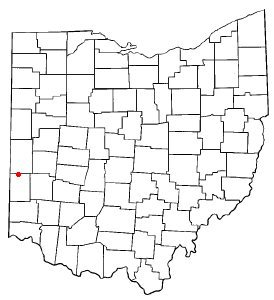
Eldorado is a village in Preble County, Ohio, United States. The population was 458 at the 2020 census. It is part of the Dayton Metropolitan Statistical Area.
Its first post office opened in 1854. Between the 2010 and 2020 censuses its population fell from 509 to 458 (-10%).
Intro from Wikipedia. Population: U.S. Census Bureau.
From the old history books
What they wrote about Eldorado in 1915
Passages that mention Eldorado, cut from the printed page as they were published.
The first house erected in Eldorado, one mile south of the north county line, was built by Leroy R. McWhinney in 1852. McWhinney also started a store and mill, depot and grain house, near the track of the Dayton & Western railroad, which then had just been completed; then laid out the town on his own land and continued business for a number of years.
Text read by machine from the scan; it may contain errors.
three years. At the end of that time, in September, 1895, he moved to Eldorado, Ohio, and there learned the baker's trade, and for eight years was engaged in the bakery and restaurant business. On June 7, 1897, he was appointed postmaster of Eldorado, under President McKinley, and served in this capacity until October 1, 1914. Mr. Hamilton was with his brotherin-law, Jesse King, about three years in the operation of a general store, at the end of which time he purchased his brother-in-law's interest in this store, and has since conducted the store alone. He is now vice-president of the
Text read by machine from the scan; it may contain errors.
Scans and text from the Internet Archive. Books published in 1930 or earlier, which are in the public domain.
Timeline
Eldorado, 1850 to 1960
Woven from the archive, old maps, post office records, the National Register and the people born here.
Founding dates: Wikidata, Wikipedia, the U.S. post office records of Blevins & Helbock (CC0) and the Census. Homes by year built: Census ACS 2020–24. National Register of Historic Places: National Park Service (list of May 22, 2026). Old photos, postcards and papers: Wikimedia Commons, the Library of Congress and other public archives, credited on each item’s page. Maps: U.S. Geological Survey historical topographic maps (via Esri) and Sanborn fire-insurance maps (Library of Congress). History text and census tables: Wikipedia (CC BY-SA 4.0). Places that used to be: USGS Geographic Names Information System (2021). How TownRatings grades history →
From Wikimedia Commons (4), U.S. Geological Survey historical maps, U.S. Census counts (via Wikipedia), the US Post Offices dataset (Blevins & Helbock), the USGS Geographic Names Information System and old county and town histories (Internet Archive). Archive images are copied here with their credits and licenses, shown on each photo’s page. Refreshed monthly.


 2016
 2016
 2015
 2004