Dayton has 111 places on the National Register, 3 of them National Historic Landmarks
More historic than 98% of U.S. towns · #14 of 993 in Ohio. What drives it
Dated to 1796 (Wikidata and Wikipedia’s history), with 37% of its homes built before 1940 and 26 historic districts holding 5,807 contributing buildings. Below: 12 old photos and papers, maps from 1887 on, the census since 1810, and every listing on the Register.
Founding year: Wikidata; Wikipedia’s history section gives the same year. First post office: 1803.The full story ↓
History grade
What drives Dayton’s History grade
On its age, its old homes and the National Register, Dayton is more historic than 98% of U.S. towns, #14 of 993 in Ohio. All 3 inputs are above most U.S. towns; its National Register listings ranks highest and its age lowest.
A+
HistoryA character grade: shown, never part of Dayton’s overall grade.
Among the 400 U.S. cities of 100,000 or more, Dayton ranks #26 on History.
Ohio towns list about as much on the Register as the country (a typical Ohio town has 2.9 per 10,000 residents, the U.S. 2.4), so Dayton’s 425 sits above most of its state (98% of Ohio towns have fewer) while its 5,807 historic buildings outnumber those of 100% of U.S. towns.
How sure. Graded on any two of the three inputs instead, the letter would range from A to A+. The pre-1940 share (±1.5 points) is firm at this size. Two sources give 1796.
Founding year: Wikidata (other dates in Quick answers). Homes: Census ACS 2020–24. National Register: National Park Service, May 2026 list; each listing counted once (boundary changes and added documentation belong to their listing), and a historic district counts its contributing buildings. How TownRatings grades history →
What stands out about Dayton’s past
Read from the archive, the National Register and the record. The page puts what stands out first.
The country’s official list of buildings and places worth saving. 3 are National Historic Landmarks, the highest tier. Boundary changes and added documentation are counted with their listing.
National Park Service, National Register of Historic Places. Photos from Wikimedia Commons, credited on each place’s page.
Places that used to be
Lost post offices, old corners, places now gone and burying grounds
Dayton’s post office has been open since 1803. Another post office, Harshman, opened and closed inside today’s town.
Dayton
1803–today
Harshman
1885–1914
18001910today
Hamlets and corners on the map
American Trailer ParkAvondale Trailer CourtBelmontCornell HeightsCrown PointDaytonviewDeerpark VillageEast DaytonEdgemontFairviewFort McKinleyHarriesHearthstoneLinda's Web Mobile Home ParkNorth RiverdaleOaklandOhmer ParkPattersonResidence ParkRidgewood HeightsRiverdaleSunny Acres Mobile Home ParkUpper Dayton ViewValley Trailer Court
Gone or out of use
Dayton Army Air FieldmilitaryFairport Middle SchoolschoolFranciscan Medical CenterhospitalGardendale SchoolschoolGood Samaritan Hospital HeliportairportHoly Family SchoolsschoolJackson Elementary SchoolschoolKennedy Elementary SchoolschoolLange Elementary SchoolschoolMcGuffey Elementary SchoolschoolMcKinley Elementary SchoolschoolQueen of Martyrs SchoolschoolResidence Park Elementary SchoolschoolSalem Dartmouth HospitalhospitalSteele High SchoolschoolWillard Elementary Schoolschool
11cemeteries and burying grounds inside Dayton
Daniel MillerDayton NationalFlorenceFort McKinleyGreencastleHoldermanJewishOld GreencastleUniversity of DaytonWestmontWoodland
US Post Offices dataset (Blevins & Helbock, CC0). Places and cemeteries from the USGS Geographic Names Information System (2021).
Dayton was founded on April 1, 1796, by 12 settlers known as the Thompson Party. They traveled in March from Cincinnati up the Great Miami River by pirogue and landed at what is now St. Clair Street, where they found two small camps of Native Americans. Among the Thompson Party was Benjamin Van Cleve, whose memoirs provide insights into the Ohio Valley's history. Two other groups traveling overland arrived several days later. The oldest surviving building is Newcom Tavern, which was used for various purposes, including housing Dayton's first church, which is still in existence.
Passages that mention Dayton, cut from the printed page as they were published.
History of Dayton, Ohio. With portraits and biographical sketches of some of its pioneer and prominent citizens1889Read the page →
Read the text
The railroad track on the Dayton & Michigan Railroad, just this side of Troy, was washed away, and travel stopped in that direction. <A bridge on the Dayton & Western Railroad, near New Paris, was destroyed, and five bridges on the Indiana Central, between Piqua and Columbus, also.
Text read by machine from the scan; it may contain errors.
History of Dayton, Ohio. With portraits and biographical sketches of some of its pioneer and prominent citizens1889Read the page →
Read the text
“EBRUARY 12, 1805, the legislature incorporated the town of Dayton. } Lhe town government consisted of seven trustees, a collector, supervisor, and marshal, clected by free-holders, who had lived in Dayton six months. <A president, who acted as mayor, and a recorder were to be elect a treasurer who need not be a member of their board. The board of trustees was called “the select council of the town of Dayton.” The first clection under the act of incorporation occurred on the first Monday in May, 1805.
Text read by machine from the scan; it may contain errors.
An outline of the history of Dayton, Ohio, 1796-18961896 · page 36Read the page →
Scans and text from the Internet Archive. Books published in 1930 or earlier, which are in the public domain.
Timeline
Dayton, 1795 to 1955
Woven from the archive, old maps, post office records, the National Register and the people born here.
Nothing in the archives for these yearsWeddings on Main Street, storms, parades, school pictures, the old store. If it’s in your family album, it belongs here.
Every edition of the U.S. Geological Survey’s map of Dayton. Tap a year, or press play to watch the town change.
1955Dayton North sheet · 1:24,000
U.S. Geological Survey historical topographic maps (public domain), via Esri’s collection of the scans. The red ring marks the center of Dayton.
Every building
Dayton, building by building, 1887–1919
Fire insurance maps drew every building, what it was made of and what it was used for, so insurers could price the risk of fire. Pick a year, then a sheet.
In 1796, according to Wikidata and Wikipedia’s history of the town. Dayton’s post office opened in 1803, and the census of 1810 counted 383 people here.
How does Dayton rank for history?
Dayton is more historic than 98% of U.S. towns, #14 of 993 in Ohio. The History grade combines the town’s founding era, the share of homes built before 1940 and its National Register listings. It’s a character grade, so it isn’t part of the overall grade. How it works.
What is on the National Register in Dayton?
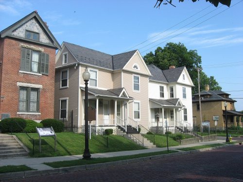
111 listings, 3 of them National Historic Landmarks: 84 buildings, among them the Paul Laurence Dunbar House (a National Historic Landmark since 1962), 26 historic districts with 5,690 contributing buildings, and 1 structure. 5,807 historic buildings in all.
How old are the homes in Dayton?
37% of Dayton’s homes were built before 1940 (Census estimate, ±1.5 points), against a typical 15% for an Ohio town; the median home was built in 1951.
Founding dates: Wikidata, Wikipedia, the U.S. post office records of Blevins & Helbock (CC0) and the Census. Homes by year built: Census ACS 2020–24. National Register of Historic Places: National Park Service (list of May 22, 2026). Old photos, postcards and papers: Wikimedia Commons, the Library of Congress and other public archives, credited on each item’s page. Maps: U.S. Geological Survey historical topographic maps (via Esri) and Sanborn fire-insurance maps (Library of Congress). History text and census tables: Wikipedia (CC BY-SA 4.0). Places that used to be: USGS Geographic Names Information System (2021).
From Wikimedia Commons (6), the Library of Congress (6), Wikidata (3), the National Register of Historic Places (111), Wikipedia, Wikidata and Wikipedia for famous people, U.S. Geological Survey historical maps, U.S. Census counts (via Wikipedia), the US Post Offices dataset (Blevins & Helbock), the USGS Geographic Names Information System, Sanborn fire insurance maps (Library of Congress) and old county and town histories (Internet Archive). Archive images are copied here with their credits and licenses, shown on each photo’s page. Refreshed monthly.


 ★ Landmark
 ★ Landmark
 ★ Landmark







 1889
 1900
 1900
 1901
 1902
 1902


