Coshocton dates to 1802, and 37% of its homes were built before 1940
More historic than 97% of U.S. towns · #32 of 993 in Ohio. What drives it
7 places in town are on the National Register, among them two historic districts with 133 buildings between them. Below: 6 old photos and papers, maps from 1884 on, and the census since 1830.
Founding year: Wikidata. First post office: 1811.The full story ↓
History grade
What drives Coshocton’s History grade
On its age, its old homes and the National Register, Coshocton is more historic than 97% of U.S. towns, #32 of 993 in Ohio. All 3 inputs are above most U.S. towns; its National Register listings ranks highest and its age lowest.
A+
HistoryA character grade: shown, never part of Coshocton’s overall grade.
Ohio towns list about as much on the Register as the country (a typical Ohio town has 2.9 per 10,000 residents, the U.S. 2.4), so Coshocton’s 131 sits above most of its state (94% of Ohio towns have fewer) while its 145 historic buildings outnumber those of 91% of U.S. towns.
How sure. Graded on any two of the three inputs instead, the letter would range from A to A+. The pre-1940 share is a Census survey estimate (±4.7 points). Two sources give 1802.
Founding year: Wikidata (other dates in Quick answers). Homes: Census ACS 2020–24. National Register: National Park Service, May 2026 list; each listing counted once (boundary changes and added documentation belong to their listing), and a historic district counts its contributing buildings. How TownRatings grades history →
What stands out about Coshocton’s past
Read from the archive, the National Register and the record. The page puts what stands out first.
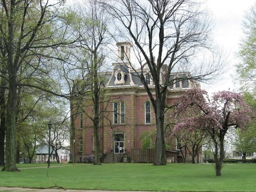
National Park Service, National Register of Historic Places. Photos from Wikimedia Commons, credited on each place’s page.
Places that used to be
Lost post offices, old corners, places now gone and burying grounds
Coshocton’s post office has been open since 1811. Two other post offices opened and closed inside today’s town.
Coshocton
1811–today
Caldersburgh
1826–1831
Roscoe
1831–1961
18101920today
Hamlets and corners on the map
Chestnut Trailer CourtClover Trailer ParkClowvilleDowntown Mobile VillageH and W Mobile Home ParkPleasant ValleyRoscoe
Gone or out of use
Clark SchoolschoolCoshocton County InfirmarybuildingRoscoe Post Officepost officeRoscoe Schoolschool
3cemeteries and burying grounds inside Coshocton
Oak RidgeRoscoeSouth Lawn
US Post Offices dataset (Blevins & Helbock, CC0). Places and cemeteries from the USGS Geographic Names Information System (2021).
Every building
Coshocton, building by building, 1884–1925
Fire insurance maps drew every building, what it was made of and what it was used for, so insurers could price the risk of fire. Pick a year, then a sheet.
The Lenape sympathetic to the new United States stayed near Coshocton, then called Gosch-ach-gunk. White Eyes, then leader of the Lenape people, signed the Treaty of Fort Pitt of 1778, by which the Lenape hoped to secure their safety during the War, and he promised scouts and support to the rebel colonists.
In retaliation for frontier raids by hostile Lenape and British, Colonel Daniel Brodhead of the Continental Army ignored the treaty. After indiscriminately raiding and destroying the peaceful Moravian Christian Lenape settlement of Indaochaic also known as Lichtenau, he attacked and destroyed the Lenape at Coshocton in April 1781.
Passages that mention Coshocton, cut from the printed page as they were published.
History of Coshocton County, Ohio1881 · page 442Read the page →
Read the text
WyUe, the first minister who was installed as pastor of the church. During the five years of his ministry (1836-1841) some forty-eight members were added at Coshocton, and the church was incorporated by act of the legislature as " The First Presbyterian Church of the town of Coshocton, in Coshocton county."
Text read by machine from the scan; it may contain errors.
History of Coshocton County, Ohio1881 · page 442Read the page →
Read the text
Wylie, the first minister who was installed as pastor of the church. During the five years of his ministry (1S36-1.S41) some forty-eight' members were added at Coshocton, and the church was incorporated by act of the legislature as " The First Presbyterian Church of the town of Coshocton, in Coshocton county."
Text read by machine from the scan; it may contain errors.
History of Coshocton County, Ohio1881 · page 411Read the page →
Read the text
The town of Coshocton was laid out in April, 1802, by John Matthews and Ebenezer Buckingham, Jr. In their survey they were assisted by Gibson Rook, and two town lots were given him for his services. The town was christened Tuscarawa, but the name was changed to Coshocton by act of the legislature in 1811.
Text read by machine from the scan; it may contain errors.
Historical collections of Coshocton County, Ohio1876Read the page →
Read the text
being unable or unwilling to assist in bridging said stream, he petitioned the legislature, in 1834, to authorize him to build a bridge and collect toll. This was the first bridge spanning Will's creek in Coshocton county, and remained a tollbridge about twenty years, when his son made a free-will offering of the bridge to the county commissioners, they agreeing to repair and keep it up. He was connected with the building of the bridges that span the Tuscarawas and Wal-
Text read by machine from the scan; it may contain errors.
Scans and text from the Internet Archive. Books published in 1930 or earlier, which are in the public domain.
Timeline
Coshocton, 1802 to 1961
Woven from the archive, old maps, post office records, the National Register and the people born here.
Nothing in the archives for these yearsWeddings on Main Street, storms, parades, school pictures, the old store. If it’s in your family album, it belongs here.
In 1802, according to Wikidata. Coshocton’s post office opened in 1811, and the census of 1830 counted 333 people here.
How does Coshocton rank for history?
Coshocton is more historic than 97% of U.S. towns, #32 of 993 in Ohio. The History grade combines the town’s founding era, the share of homes built before 1940 and its National Register listings. It’s a character grade, so it isn’t part of the overall grade. How it works.
What is on the National Register in Coshocton?
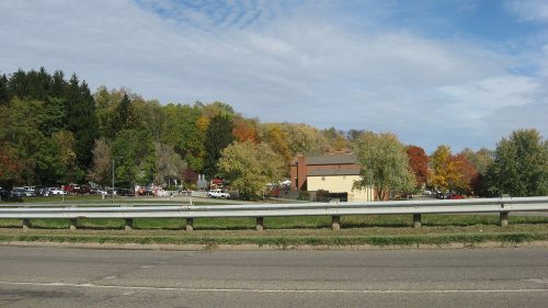
7 listings: 5 buildings and 2 historic districts, the Roscoe Village and the Coshocton Main Street Historic District, with 133 contributing buildings. 145 historic buildings in all.
How old are the homes in Coshocton?
37% of Coshocton’s homes were built before 1940 (Census estimate, ±4.7 points), against a typical 15% for an Ohio town; the median home was built in 1954.
Founding dates: Wikidata, Wikipedia, the U.S. post office records of Blevins & Helbock (CC0) and the Census. Homes by year built: Census ACS 2020–24. National Register of Historic Places: National Park Service (list of May 22, 2026). Old photos, postcards and papers: Wikimedia Commons, the Library of Congress and other public archives, credited on each item’s page. Maps: U.S. Geological Survey historical topographic maps (via Esri) and Sanborn fire-insurance maps (Library of Congress). History text and census tables: Wikipedia (CC BY-SA 4.0). Places that used to be: USGS Geographic Names Information System (2021).
From Wikimedia Commons (3), the Library of Congress (3), the National Register of Historic Places (7), Wikipedia, Wikidata and Wikipedia for famous people, U.S. Geological Survey historical maps, U.S. Census counts (via Wikipedia), the US Post Offices dataset (Blevins & Helbock), the USGS Geographic Names Information System, Sanborn fire insurance maps (Library of Congress) and old county and town histories (Internet Archive). Archive images are copied here with their credits and licenses, shown on each photo’s page. Refreshed monthly.






 1903
 1903
 1904
 1907
 1907


