


The story
Read it all →How Clinton came to be
From Wikipedia’s history of Clinton.
Clinton was originally called Savannah, and under the latter name was laid out in 1816.
Text from Wikipedia, licensed CC BY-SA 4.0.
Each edition grades its towns against each other only.
More historic than 96% of U.S. towns. What drives it
11 places in town are on the National Register, among them two historic districts with 2 buildings between them. Below: maps from 1901 on and the census since 1910.
The Clinton post office opened in 1829, the earliest record of the town by name. Another post office, Warwick (1893), opened inside today’s town and later closed.
More historic than 96% of U.S. towns, on its age, its old homes and the National Register.
On its age, its old homes and the National Register, Clinton is more historic than 96% of U.S. towns. All 3 inputs are above most U.S. towns; its share of homes from before 1940 ranks highest and its age lowest.
Ohio towns list about as much on the Register as the country (a typical Ohio town has 2.9 per 10,000 residents, the U.S. 2.4), so Clinton’s 132 sits above most of its state (94% of Ohio towns have fewer) while its 16 historic buildings outnumber those of 78% of U.S. towns.
Founding year: the first post office (other dates in Quick answers). Homes: Census ACS 2020–24. National Register: National Park Service, May 2026 list; each listing counted once (boundary changes and added documentation belong to their listing), and a historic district counts its contributing buildings. How TownRatings grades history →
Read from the archive, the National Register and the record. The page puts what stands out first.
The first neighbors to add old photos shape how Clinton’s history is told.
Every edition of the U.S. Geological Survey’s map of Clinton. Tap a year, or press play to watch the town change.

U.S. Geological Survey historical topographic maps (public domain), via Esri’s collection of the scans. The red ring marks the center of Clinton.
The country’s official list of buildings and places worth saving.


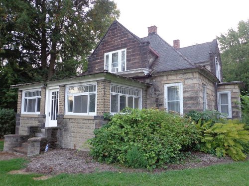


National Park Service, National Register of Historic Places. Photos from Wikimedia Commons, credited on each place’s page.
From Wikipedia’s history of Clinton.
Clinton was originally called Savannah, and under the latter name was laid out in 1816.
Text from Wikipedia, licensed CC BY-SA 4.0.
Passages that mention Clinton, cut from the printed page as they were published.

Clinton” : “Section 1. Be it enacted by the General Assembly of the State of Ohio, That all that part of Highland county within the following boundaries be and the same is hereby ‘attached to and shall remain the county of Clinton: Beginning at the southeast corner of Clinton county, adjoining Fayette county, thence running a line in a southwesterly direction to strike the line of Clinton county at such a point as to include four hundred square miles in the county of Clinton.
Text read by machine from the scan; it may contain errors.
Ohio at Marion, Ohio, this marking the close of the present administration. The only other corps in Clinton county is the Jonathan Casto Corps No. 37, at Blanchester. : DAUGHTERS OF THE AMERICAN REVOLUTION, George Clinton Chapter, Daughters of the American Revolution, was named in honor of Gen. George Clinton. for whom Clinton county was named. Clinton was a brigadiergeneral in the Revolutionary army in 1777. the first governor of the state of New York, and at the time of his death was vice-president of the United States. The chapter was organized on January 30, 1896. Mrs. C. C. Nichols had been appointed chapter regent
Text read by machine from the scan; it may contain errors.
Clinton Valley is situated on the Marietta Railroad, at the crossing of Wilmington & Westboro Free Turnpike, twelve miles from Wilmington, and is noted for being a great coaling and water station for said road, which gives employment to a number of men. It contains about 100 inhabitants; has two good stores, which are patronized with a lively trade; one steam saw-mill; also a good brick schoolhouse.
Text read by machine from the scan; it may contain errors.Scans and text from the Internet Archive. Books published in 1930 or earlier, which are in the public domain.
Woven from the archive, old maps, post office records, the National Register and the people born here.
 2015William Smith House in
 2015Clinton village hall
 2015Clinton former high school
 2015Clinton Carpenter Gothic church
 2015Map of Summit County Ohio Highlighting Clinton VillageMap
 2012William Smith House 7894 Main St
 2012Warwick Interlocking Tower 2955 S. First St
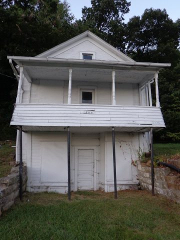 2012Louis Schmitt House and Store 2967 Hickory St
 2012Limbach Block Historic District
 2012Jonathan Price House 7903 Main St
 2012Humberger House 7616 N. Second St
 2008SORRICK-OSTER STORE
 2008PORTER-AUE HOUSE
 2008FRANCIS BECKER HOUSE
 2008DAVID SMITH HOUSE
 2008CLINTON OHIO AND ERIE CANAL HISTORIC DISTRICT, SUMMIT…
 2006Clinton-SummitCoOH
 2004OHMap-doton-Clinton
Between 305 and 1,337 people in every census since 1910.
12 censuses, 1910–2020.
U.S. Census Bureau decennial counts, from the census table on Clinton’s Wikipedia page.
Clinton’s post office has been open since 1829. Another post office, Warwick, opened and closed inside today’s town.
US Post Offices dataset (Blevins & Helbock, CC0). Places and cemeteries from the USGS Geographic Names Information System (2021).
Each neighbor’s History grade, on the same three inputs.
The Clinton post office opened in 1829, the earliest record of the town by name (U.S. post office records).
Clinton is more historic than 96% of U.S. towns. The History grade combines the town’s founding era, the share of homes built before 1940 and its National Register listings. It’s a character grade, so it isn’t part of the overall grade. How it works.
11 listings: 9 buildings and 2 historic districts, the Limbach Block Historic District and the Clinton Ohio and Erie Canal Historic District-Clinton Lock 2 and 3-Clinton Upper (Lock 2) and Clinton Lower (Lock 3), with 2 contributing buildings. 16 historic buildings in all.
37% of Clinton’s homes were built before 1940 (Census estimate, ±9.1 points), against a typical 15% for an Ohio town; the median home was built in 1954.
What the archives can’t tell you, neighbors can.
Founding dates: Wikidata, Wikipedia, the U.S. post office records of Blevins & Helbock (CC0) and the Census. Homes by year built: Census ACS 2020–24. National Register of Historic Places: National Park Service (list of May 22, 2026). Old photos, postcards and papers: Wikimedia Commons, the Library of Congress and other public archives, credited on each item’s page. Maps: U.S. Geological Survey historical topographic maps (via Esri) and Sanborn fire-insurance maps (Library of Congress). History text and census tables: Wikipedia (CC BY-SA 4.0). Places that used to be: USGS Geographic Names Information System (2021).
From Wikimedia Commons (18), the National Register of Historic Places (11), Wikipedia, Wikidata and Wikipedia for famous people, U.S. Geological Survey historical maps, U.S. Census counts (via Wikipedia), the US Post Offices dataset (Blevins & Helbock), the USGS Geographic Names Information System and old county and town histories (Internet Archive). Archive images are copied here with their credits and licenses, shown on each photo’s page. Refreshed monthly.

