Founding year: Wikidata. First post office: 1828.The full story ↓
History grade
What drives Avon’s History grade
On its age, its old homes and the National Register, Avon is more historic than 54% of U.S. towns, #610 of 993 in Ohio. Its age holds the grade up; its share of homes from before 1940 pulls it down.
B−
HistoryA character grade: shown, never part of Avon’s overall grade.
Ohio towns list about as much on the Register as the country (a typical Ohio town has 2.9 per 10,000 residents, the U.S. 2.4), so Avon’s 2.4 sits near the middle of its state (54% of Ohio towns have fewer) while its 6 historic buildings outnumber those of 72% of U.S. towns.
How sure. Graded on any two of the three inputs instead, the letter would range from C to A−. The pre-1940 share (±0.9 points) is firm at this size. Two sources give 1814.
Founding year: Wikidata (other dates in Quick answers). Homes: Census ACS 2020–24. National Register: National Park Service, May 2026 list; each listing counted once (boundary changes and added documentation belong to their listing), and a historic district counts its contributing buildings. How TownRatings grades history →
What stands out about Avon’s past
Read from the archive, the National Register and the record. The page puts what stands out first.
Every edition of the U.S. Geological Survey’s map of Avon. Tap a year, or press play to watch the town change.
1901Oberlin sheet · 1:62,500
U.S. Geological Survey historical topographic maps (public domain), via Esri’s collection of the scans. The red ring marks the center of Avon.
Places that used to be
Lost post offices, old corners, places now gone and burying grounds
Avon’s post office has been open since 1828. Two other post offices opened and closed inside today’s town.
Avon
1828–today
Folger
1891–1918
Trinity
1898–1903
18201920today
Hamlets and corners on the map
Avon CenterTrinity
Gone or out of use
Avon AirportairportAvon Lake Post Officepost officeBalunek AirportairportBosworth Incorporated AirportairportFolger Post Officepost officeJohnsons FieldairportKeller AirportairportTrinity Post Officepost office
In the 17th century, what is now Avon, Avon Lake, Bay Village, and Westlake were all once one territory. This territory was inhabited by various Native American tribes, such as the Wyandots, Ottawas, and Eries, who lived in wigwams or simple-stone dwellings. They settled, traded, fought, and later forcibly moved elsewhere.
Passages that mention Avon, cut from the printed page as they were published.
History of Lorain County Ohio with Illustrations and Biographical Sketches of Some of Its Prominent Men and Pionners1879Read the page →
Read the text
Through the township of Avon this road passes very near the bank of the Jake,-and here, where is now a succession of tasty cottages and beautiful villas, Noah Davis, in the year 1812, made a settlement, the first in the township. He erected the first log house, but where it was located, or who composed his family, we have been unable to ascertain, as he only remained a short time, removing from the township in less than
Text read by machine from the scan; it may contain errors.
A standard history of Lorain county, Ohio1916Read the page →
Read the text
Davis Settles on Lake Siioke Road "Early in the history of the Western Reserve a road was established from Cleveland westward along the shore of the lake. Over this mail was transported as early as 1807. Through tiie township of Avon, this road passed very near the bank of tlu; lake and here, where is now a succession of tasty cottages and beautiful villas, Noah Davis, in the year 1812, made a settlement, the first in the township. He erected the first log house, but where it was located, or who composed his family, we have
Text read by machine from the scan; it may contain errors.
A standard history of Lorain county, Ohio1916Read the page →
Read the text
Avon Township Created On the 27th of October, 1818, the Town of Avon, together with the annexations hereinbefore stated, was set off from Dover, and organized in a separate township by the name of Troy, by the commissioners of Cuyahoga County. It will l)e remembered that, at tliis date, the river from the point where it passes into Slieffield north to the lake was the boundary line between Huron and Cuyahoga counties. A special election was ordered for township officers, to be held Noveml)er 1), 1818.
Text read by machine from the scan; it may contain errors.
The early history of Lorain County. An address1876 · page 21Read the page →
Read the text
ing it was a part of Dover. In December, 1824, upon petition of forty citizens, the name of the town was changed from Troy to Avon, by the commissioners of Lorain county. In 1818, the first school-house was built, near the center of the town, and in the fall of that year, Larkin A. Williams opened
Text read by machine from the scan; it may contain errors.
Scans and text from the Internet Archive. Books published in 1930 or earlier, which are in the public domain.
Timeline
Avon, 1814 to 1918
Woven from the archive, old maps, post office records, the National Register and the people born here.
In 1814, according to Wikidata. Avon’s post office opened in 1828, and the census of 1920 counted 1,460 people here.
How does Avon rank for history?
Avon is more historic than 54% of U.S. towns, #610 of 993 in Ohio. The History grade combines the town’s founding era, the share of homes built before 1940 and its National Register listings. It’s a character grade, so it isn’t part of the overall grade. How it works.
What is on the National Register in Avon?
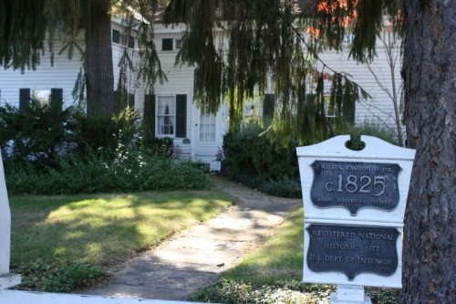
5 listings: 5 buildings, among them the William E. Hurst House (listed 1974, the first). 6 historic buildings in all.
How old are the homes in Avon?
2% of Avon’s homes were built before 1940 (Census estimate), against a typical 15% for an Ohio town; the median home was built in 2001.
Founding dates: Wikidata, Wikipedia, the U.S. post office records of Blevins & Helbock (CC0) and the Census. Homes by year built: Census ACS 2020–24. National Register of Historic Places: National Park Service (list of May 22, 2026). Old photos, postcards and papers: Wikimedia Commons, the Library of Congress and other public archives, credited on each item’s page. Maps: U.S. Geological Survey historical topographic maps (via Esri) and Sanborn fire-insurance maps (Library of Congress). History text and census tables: Wikipedia (CC BY-SA 4.0). Places that used to be: USGS Geographic Names Information System (2021).
From Wikimedia Commons (3), Wikidata (3), the National Register of Historic Places (5), Wikipedia, U.S. Geological Survey historical maps, U.S. Census counts (via Wikipedia), the US Post Offices dataset (Blevins & Helbock), the USGS Geographic Names Information System and old county and town histories (Internet Archive). Archive images are copied here with their credits and licenses, shown on each photo’s page. Refreshed monthly.


 2023
 2023
 2012