1 place in town is on the National Register, among them a historic district with 268 buildings. Below: 8 old photos and papers, maps from 1885 on, and the census since 1830.
The Randolph post office opened in 1828, the earliest record of the town by name. Another post office, Bowen (1891), opened inside today’s town and later closed.
First census: 776 in 18302020 census: 2,469198 years
How historic is Randolph?
A+
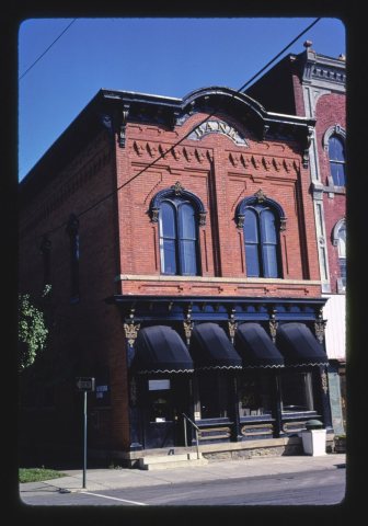
More historic than 98% of U.S. towns, on its age, its old homes and the National Register.
Founding year: the first Randolph post office (Blevins & Helbock, CC0).The full story ↓
History grade
What drives Randolph’s History grade
On its age, its old homes and the National Register, Randolph is more historic than 98% of U.S. towns. All 3 inputs are above most U.S. towns; its share of homes from before 1940 ranks highest and its age lowest.
A+
HistoryA character grade: shown, never part of Randolph’s overall grade.
New York towns list more on the Register than most of the country (a typical New York town has 12.3 per 10,000 residents, the U.S. 2.4), so Randolph’s 1,243 sits above most of its state (97% of New York towns have fewer) while its 268 historic buildings outnumber those of 95% of U.S. towns.
How sure. Graded on any two of the three inputs instead, the letter would range from A to A+. The pre-1940 share is a Census survey estimate (±6.0 points). The founding year is the first post office, not a stated founding date.
Founding year: the first post office (other dates in Quick answers). Homes: Census ACS 2020–24. National Register: National Park Service, May 2026 list; each listing counted once (boundary changes and added documentation belong to their listing), and a historic district counts its contributing buildings. How TownRatings grades history →
What stands out about Randolph’s past
Read from the archive, the National Register and the record. The page puts what stands out first.
National Park Service, National Register of Historic Places. Photos from Wikimedia Commons, credited on each place’s page.
Every building
Randolph, building by building, 1885–1913
Fire insurance maps drew every building, what it was made of and what it was used for, so insurers could price the risk of fire. Pick a year, then a sheet.
The town of Randolph sits on the vast tracts of land which were originally owned by the Holland Land Company. The region was first settled around 1820. The first settler was Edmund Fuller, who arrived from Oneida County in 1820 and built a log cabin.
The town of Randolph was formed in 1826 from part of the town of Conewango. On March 7, 1826, citizens assembled for their first annual meeting to select the town supervisor and other officials. In 1847, the town was divided to form the town of South Valley.
Passages that mention Randolph, cut from the printed page as they were published.
History of Randolph County, Missouri1920 · page 216Read the page →
Read the text
In 1871 the Chicago and Alton Railroad Company constructed its line of railroad westward from Mexico through Randolph County and from thence westward to Kansas City. With the completion of these several roads and branch lines all constructed within the fifteen years elapsing between 1858 and 1873, Randolph County had probably a greater mileage of railroads than any inland county within the state. At the present day that part of the Missouri, Kansas and Texas Railroad extending from Moberly to Hannibal is used by both the Missouri, Kansas and Texas and
Text read by machine from the scan; it may contain errors.
a fancied wrong conjured up by the brain of some would-be chieftain, they would raise the war-whoop and sally forth, seeking whom they might devour. Hence, when in the year 1829, these first settlers of Randolph County, together with others that had then made Randolph County their future home, heard from a messenger, fresh from the scene of the conflict, his fiery charger foaming, being driven by the whip and spur to his utmost speed, that the Indians on the northern borders had raised the war club and were marching rapidly to the settlements, murdering
Text read by machine from the scan; it may contain errors.
A history of Randolph County, West Virginia, from its earliest exploration and settlement to the present time1916 · page 88Read the page →
Read the text
On October 27, 1790, Abraham Clavpool and Cornelius Bogard, delegates to the Assembly from Randolph County, addressed a memorial to the Governor of Virginia praying that the four scouts from Randolph be allowed their claims for services rendered during the year, 1789. These delegates also petitioned Governor Beverly Randolph, Nov. 1, 1790, stating the defenseless condition of the counties for 400 miles along the Ohio river exposed to the hostile invasion of the
Text read by machine from the scan; it may contain errors.
A history of Randolph County, West Virginia, from its earliest exploration and settlement to the present time1916 · page 405Read the page →
Read the text
Maxwell Armstrong was Prosecuting Attorney of Randolph from 1795 to 1798. He was practicing at the Randolph County bar as late as 1795, when he was engaged by the County Court to bring suit against Edward Hart for failure to complete the court house in the time specified in the contract Another family of the same name settled in Randolph about this time. They were from Prince William County, Virginia Whether relatives of Maxwell Armstrong is not known.
Text read by machine from the scan; it may contain errors.
Scans and text from the Internet Archive. Books published in 1930 or earlier, which are in the public domain.
Timeline
Randolph, 1828 to 1988
Woven from the archive, old maps, post office records, the National Register and the people born here.
Nothing in the archives for these yearsWeddings on Main Street, storms, parades, school pictures, the old store. If it’s in your family album, it belongs here.
Nothing in the archives for these yearsWeddings on Main Street, storms, parades, school pictures, the old store. If it’s in your family album, it belongs here.
Lost post offices, old corners, places now gone and burying grounds
Randolph’s post office has been open since 1828. Another post office, Bowen, opened and closed inside today’s town.
Randolph
1828–today
East Randolph
1849–today
Bowen
1891–1907
18201920today
Hamlets and corners on the map
BowenVollentine
Gone or out of use
Cowen's Flying FieldairportEdwards Memorial Methodist Episcopal ChurchchurchFirst Congregational ChurchchurchSchool Street Building Randolph Central Schoolschool
3cemeteries and burying grounds inside Randolph
East RandolphRandolphSample Hill
US Post Offices dataset (Blevins & Helbock, CC0). Places and cemeteries from the USGS Geographic Names Information System (2021).
Help out
Finish Randolph’s story
Most archives stop around 1920. The photos from after that are in family albums, not libraries.
Decades since 1900 with photos
00s10s20s30s40s50s60s70s80s90s
2 of 10 decades. The empty ones are waiting for someone’s album.
The Randolph post office opened in 1828, the earliest record of the town by name (U.S. post office records).
How does Randolph rank for history?
Randolph is more historic than 98% of U.S. towns. The History grade combines the town’s founding era, the share of homes built before 1940 and its National Register listings. It’s a character grade, so it isn’t part of the overall grade. How it works.
What is on the National Register in Randolph?
One place: the Randolph Historic District (listed 2012).
How old are the homes in Randolph?
46% of Randolph’s homes were built before 1940 (Census estimate, ±6.0 points), against a typical 27% for a New York town; the median home was built in 1945.
Founding dates: Wikidata, Wikipedia, the U.S. post office records of Blevins & Helbock (CC0) and the Census. Homes by year built: Census ACS 2020–24. National Register of Historic Places: National Park Service (list of May 22, 2026). Old photos, postcards and papers: Wikimedia Commons, the Library of Congress and other public archives, credited on each item’s page. Maps: U.S. Geological Survey historical topographic maps (via Esri) and Sanborn fire-insurance maps (Library of Congress). History text and census tables: Wikipedia (CC BY-SA 4.0). Places that used to be: USGS Geographic Names Information System (2021).
From Wikimedia Commons (7), the Library of Congress (3), Wikidata (1), the National Register of Historic Places (1), Wikipedia, Wikidata and Wikipedia for famous people, U.S. Geological Survey historical maps, U.S. Census counts (via Wikipedia), the US Post Offices dataset (Blevins & Helbock), the USGS Geographic Names Information System, Sanborn fire insurance maps (Library of Congress) and old county and town histories (Internet Archive). Archive images are copied here with their credits and licenses, shown on each photo’s page. Refreshed monthly.


 1910
 1910
 1910
 1910
 1910
 Date?
 2015
 2010


