Founding year: the first Maybrook post office (Blevins & Helbock, CC0). Wikidata: 1926.The full story ↓
History grade
What drives Maybrook’s History grade
On its age, its old homes and the National Register, Maybrook is more historic than 59% of U.S. towns, #609 of 758 in New York. Its share of homes from before 1940 holds the grade up; its age pulls it down.
B
HistoryA character grade: shown, never part of Maybrook’s overall grade.
New York towns list more on the Register than most of the country (a typical New York town has 12.3 per 10,000 residents, the U.S. 2.4), so Maybrook’s 12.7 sits near the middle of its state (50% of New York towns have fewer) while its 4 historic buildings outnumber those of 68% of U.S. towns.
How sure. Graded on any two of the three inputs instead, the letter would range from C+ to B+. The pre-1940 share is a Census survey estimate (±8.8 points). The founding year is the first post office, not a stated founding date; Wikidata gives 1926.
Founding year: the first post office (other dates in Quick answers). Homes: Census ACS 2020–24. National Register: National Park Service, May 2026 list; each listing counted once (boundary changes and added documentation belong to their listing), and a historic district counts its contributing buildings. How TownRatings grades history →
What stands out about Maybrook’s past
Read from the archive, the National Register and the record. The page puts what stands out first.
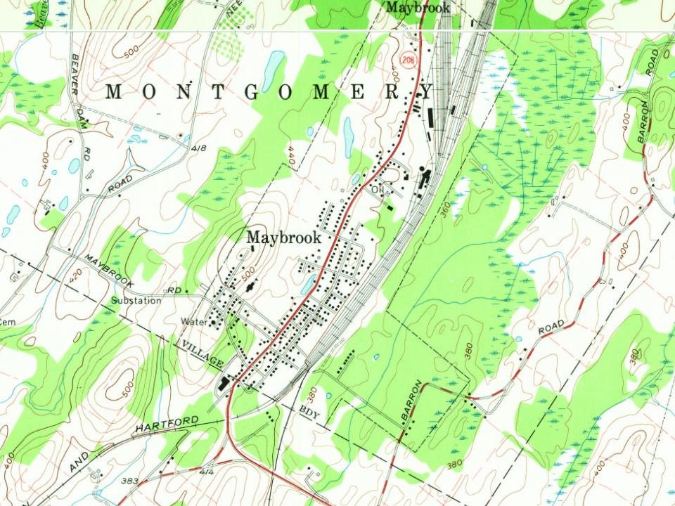
The hamlet was not incorporated as a village until 1926, making it the last of the town of Montgomery's three villages to be created. Its growth was spurred by the development of Maybrook Yard, an important railroad switching terminal where eastbound traffic from several railroads was funneled across the Poughkeepsie Bridge. At its peak, the yard employed over 1,500 workers. All yards, terminals and roundhouses have since been removed following the closing of the Poughkeepsie Bridge in 1974. There remains freight service to Maybrook via the Middletown and New Jersey Railroad.
Passages that mention Maybrook, cut from the printed page as they were published.
The history of Orange County, New York1908 · page 314Read the page →
Read the text
Maybrook is an important railway junction, in the extreme southeast corner of the town. The population, which numbers about four hundred, is composed principally of railroad employees.
Text read by machine from the scan; it may contain errors.
The history of Orange County, New York1908 · page 958Read the page →
Read the text
torates have been in the United States. For twelve years he was connected with St. Jean Baptiste Church in New York. He is much beloved by his parishioners, for whom he has accomplished such extensive improvements. He also has charge of the Maybrook mission. WILLIAM THAYER was one of Newburgh's oldest and most successful merchants. He came there from Brooklyn, Conn., in 1809. His ancestors came from England in 1636 and settled in Massachusetts, where their descendants have been among the most prominent men of that State. As recorded in history this
Text read by machine from the scan; it may contain errors.
Scans and text from the Internet Archive. Books published in 1930 or earlier, which are in the public domain.
The Maybrook post office opened in 1890, the earliest record of the town by name (U.S. post office records). Wikidata gives 1926.
How does Maybrook rank for history?
Maybrook is more historic than 59% of U.S. towns, #609 of 758 in New York. The History grade combines the town’s founding era, the share of homes built before 1940 and its National Register listings. It’s a character grade, so it isn’t part of the overall grade. How it works.
How old are the homes in Maybrook?
20% of Maybrook’s homes were built before 1940 (Census estimate, ±8.8 points), against a typical 27% for a New York town; the median home was built in 1976.
Founding dates: Wikidata, Wikipedia, the U.S. post office records of Blevins & Helbock (CC0) and the Census. Homes by year built: Census ACS 2020–24. National Register of Historic Places: National Park Service (list of May 22, 2026). Old photos, postcards and papers: Wikimedia Commons, the Library of Congress and other public archives, credited on each item’s page. Maps: U.S. Geological Survey historical topographic maps (via Esri) and Sanborn fire-insurance maps (Library of Congress). History text and census tables: Wikipedia (CC BY-SA 4.0). Places that used to be: USGS Geographic Names Information System (2021).
From Wikimedia Commons (6), Wikipedia, U.S. Geological Survey historical maps, U.S. Census counts (via Wikipedia), Sanborn fire insurance maps (Library of Congress) and old county and town histories (Internet Archive). Archive images are copied here with their credits and licenses, shown on each photo’s page. Refreshed monthly.




 2015
 2008
 2008
 2007
 2006
 2005


