The Kenvil section of Roxbury Township was originally called McCainsville.
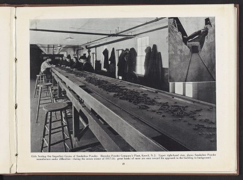
Kenvil was home to the second dynamite plant in the United States, established in 1872 by the Atlantic Giant Powder Company. After acquisition of the plant by the Hercules Powder Company in 1913, it also manufactured smokeless powder. The company experienced several major explosions, killing six people in 1934, 51 people in 1940, and shattering windows across town in 1989.
Passages that mention Kenvil, cut from the printed page as they were published.
A history of Morris County, New Jersey1914 · page 168Read the page →
Read the text
canal was finished, and in 1853 the Morris and Essex railroad was completed to Hackettstown. The Chester railroad, a branch of the M. & E. railroad, leaves the main line near Wharton, and passes through the eastern part of the township, Kenvil and Succasunna being stations on that line, which was opened for traffic in January, 1870. The High Bridge Branch of the Central Railroad of New Jersey was completed to McCainville in July, 1876, and extended to Wharton (formerly Port Oram) in 1878, a further extension to Rockaway being finished in July, 1881. Until 1872 mail was brought
Text read by machine from the scan; it may contain errors.
A history of Morris County, New Jersey1914 · page 167Read the page →
Read the text
Garbut and Francis Breck, who took up 2100 acres. On October 27, 1714, John Budd located 1054 acres south and west of Succasunna. In 1752 Ebenezer Large located 1725 acres north of Budd Lake. In 1754 William Throckmorton located lands where Succasunna and Kenvil are built, and sold the same to Cornelius Slaight. Northeast of Kenvil is the Mary Wills tract, occupied since 1869 by the Atlantic Giant Powder Company. Other locations followed, but these are the earliest of record. In 1757 Martin Ryerson located 218 acres lying north of Budd Lake, south of and
Text read by machine from the scan; it may contain errors.
Scans and text from the Internet Archive. Books published in 1930 or earlier, which are in the public domain.
By decade
Kenvil, decade by decade
One decade in the archive so far: the 1920s. Scroll each row; tap a photo for its story.
Nothing in the archives for these yearsWeddings on Main Street, storms, parades, school pictures, the old store. If it’s in your family album, it belongs here.
Founding dates: Wikidata, Wikipedia, the U.S. post office records of Blevins & Helbock (CC0) and the Census. Homes by year built: Census ACS 2020–24. National Register of Historic Places: National Park Service (list of May 22, 2026). Old photos, postcards and papers: Wikimedia Commons, the Library of Congress and other public archives, credited on each item’s page. Maps: U.S. Geological Survey historical topographic maps (via Esri) and Sanborn fire-insurance maps (Library of Congress). History text and census tables: Wikipedia (CC BY-SA 4.0). Places that used to be: USGS Geographic Names Information System (2021). How TownRatings grades history →
From Wikimedia Commons (5), Wikipedia and old county and town histories (Internet Archive). Archive images are copied here with their credits and licenses, shown on each photo’s page. Refreshed monthly.


 1920
 2026
 2026
 2022
 2018


