
The story
Read it all →How Callaway came to be
From Wikipedia’s history of Callaway.
Callaway was platted in 1885. It was named for S. R. Callaway, general manager of the Union Pacific Railroad.
Text from Wikipedia, licensed CC BY-SA 4.0.
Each edition grades its towns against each other only.
1 place in town is on the National Register, among them a historic district with 1 buildings. Below: maps from 1893 on and the census since 1890.
Callaway dates its founding to 1885 (Wikidata and Wikipedia’s history agree). The census first counted it in 1890.
Callaway was named for S. R. Callaway, general manager of the Union Pacific Railroad.
Read from the archive, the National Register and the record. The page puts what stands out first.
The first neighbors to add old photos shape how Callaway’s history is told.
Callaway’s post office has been open since 1886. Three other post offices opened and closed inside today’s town.
US Post Offices dataset (Blevins & Helbock, CC0). Places and cemeteries from the USGS Geographic Names Information System (2021).
Peaked at 833 in 1920; 563 people lived here in 2020.
14 censuses, 1890–2020.
U.S. Census Bureau decennial counts, from the census table on Callaway’s Wikipedia page.
From Wikipedia’s history of Callaway.
Callaway was platted in 1885. It was named for S. R. Callaway, general manager of the Union Pacific Railroad.
Text from Wikipedia, licensed CC BY-SA 4.0.
Passages that mention Callaway, cut from the printed page as they were published.

Street Scene in Callaw.ay in 1895 at once, and on the 7th day of October, 1890, the first regular passenger train pulled into Callaway. The depot was located neither in the old town nor the new. but half way between, on the farm of J. Woods Smith, which was purchased by the Callaway Improvement Company, on. which to lay out a new town of
Text read by machine from the scan; it may contain errors.
having located near the present site of Callaway, a Sunday-school was organized. This languished after a year or two, but was reorganized in 1886, after the town of Callaway was started. In 1883 or 1884 Elder Correll, of the Christian church at Arnold, gathered a few persons at his home and organized the first Sunday-school in that vicinity, and the
Text read by machine from the scan; it may contain errors.Scans and text from the Internet Archive. Books published in 1930 or earlier, which are in the public domain.
Woven from the archive, old maps, post office records, the National Register and the people born here.
 On the mapFirst mapped by the U.S. Geological Survey
 2012Callaway, Nebraska downtown bldg
 2012Callaway, Nebraska downtown 4
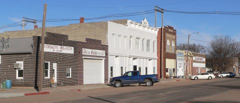 2012Callaway, Nebraska downtown 3
 2012Callaway, Nebraska Seven Valleys Museum
 2012Callaway, Nebraska Masonic Temple
 2012Callaway, Nebraska Bryners Hall
 2011Callaway, Nebraska downtown 2
 2011Callaway, Nebraska downtown 1
 2005NEMap-doton-Callaway
Every edition of the U.S. Geological Survey’s map of Callaway. Tap a year, or press play to watch the town change.

U.S. Geological Survey historical topographic maps (public domain), via Esri’s collection of the scans. The red ring marks the center of Callaway.
Fire insurance maps drew every building, what it was made of and what it was used for, so insurers could price the risk of fire. Pick a year, then a sheet.
 1893Sheet 1 of 1
Sanborn Map Company, via the Library of Congress. Editions published in 1930 or earlier, which are in the public domain.
The country’s official list of buildings and places worth saving.
National Park Service, National Register of Historic Places. Photos from Wikimedia Commons, credited on each place’s page.
Writers, athletes, leaders and more, ranked by how widely they’re known.
In 1885, according to Wikidata and Wikipedia’s history of the town. Callaway’s post office opened in 1880, and the census of 1890 counted 234 people here.
One place: the First Custer County Courthouse (listed 1990).
What the archives can’t tell you, neighbors can.
Founding dates: Wikidata, Wikipedia, the U.S. post office records of Blevins & Helbock (CC0) and the Census. Homes by year built: Census ACS 2020–24. National Register of Historic Places: National Park Service (list of May 22, 2026). Old photos, postcards and papers: Wikimedia Commons, the Library of Congress and other public archives, credited on each item’s page. Maps: U.S. Geological Survey historical topographic maps (via Esri) and Sanborn fire-insurance maps (Library of Congress). History text and census tables: Wikipedia (CC BY-SA 4.0). Places that used to be: USGS Geographic Names Information System (2021). How TownRatings grades history →
From Wikimedia Commons (9), Wikidata (1), the National Register of Historic Places (1), Wikipedia, Wikidata and Wikipedia for famous people, U.S. Geological Survey historical maps, U.S. Census counts (via Wikipedia), the US Post Offices dataset (Blevins & Helbock), the USGS Geographic Names Information System, Sanborn fire insurance maps (Library of Congress) and old county and town histories (Internet Archive). Archive images are copied here with their credits and licenses, shown on each photo’s page. Refreshed monthly.

