
Rick's Bar and Liquor sign, 1980
West Fargo’s story
100 years in pictures
Census counts: 707 in 1940, 38,626 in 2020. The archive holds 17 old photos and papers going back to 1980 and 2 maps from 1895 on.
- 1926West Fargo is settled
Each edition grades its towns against each other only.

West Fargo grades B+ overall, 7th of 23 graded towns in North Dakota, with clear strengths and some subjects that lag. Residents are healthier than 93% of U.S. towns on CDC estimates and the median household earns $91K. Its lowest everyday mark is in cost of living: homes are expensive, about $365K for a typical one and 4.8 times the Fargo metro’s $77K median household income. On civic life, just 2 of North Dakota’s 64 towns do worse. 18% of working residents work locally in West Fargo, below the North Dakota town median (39%) but above the median of U.S. towns (8%). On history, just 6 of North Dakota’s 69 towns do worse.
Where West Fargo beats most towns.
25,830 counted in 2010 and 38,626 in 2020; an estimated 41,175 in 2025.
Growth hasn’t slowed: 6.6% since 2020, after 49.5% in the decade before.
U.S. Census 2010 & 2020 counts · Census Bureau estimate, July 1, 2025
Each subject compared with towns across the country (schools within North Dakota), ordered by how far West Fargo is from typical.
How TownRatings grades towns →
Census counts: 707 in 1940, 38,626 in 2020. The archive holds 17 old photos and papers going back to 1980 and 2 maps from 1895 on.
Who provides power, water and the rest in West Fargo, and how to reach them.
EPA SDWIS (Oct 9, 2026) · HIFLD + EIA-861 2025 · Census 2020 ZCTAs · NCES 2024–25 · registration: vote.gov, updated Jul 30, 2024.
Ordered by what stands out in West Fargo.
West Fargo fares better on crime within North Dakota than nationally and has colder winter nights than nearly all U.S. towns, but it has property taxes 1.6 times the North Dakota norm.
31% of West Fargo adults sleep under 7 hours. Only 2 of the 23 North Dakota towns we compare have a lower share of adults who say their health is fair or poor than West Fargo. CDC measures, 32 in all: West Fargo beats North Dakota on 19 and trails on 1. In West Fargo, 9.3% of adults report frequent physical distress, and 16% get no exercise outside work.
| West Fargo | North Dakota towns | U.S. towns | |
|---|---|---|---|
| Binge drink (CDC PLACES) | 23% | 22% | 16% |
| Frequent physical distress (CDC PLACES) | 9.3% | 11% | 14% |
| Get no exercise (CDC PLACES) | 16% | 23% | 25% |
| High blood pressure (CDC PLACES) | 27% | 31% | 35% |
| What stands out | West Fargo | ND |
|---|---|---|
| Fewer adults with COPD | 4.1% | 5.9% |
| Fewer adults who have had a stroke | 2.2% | 3.1% |
| Fewer adults treating high blood pressure | 72.9% | 76.3% |
CDC PLACES 2025 · modeled estimates for adults · CMS · HRSA
Public schools: the West Fargo 6 school district. Three of its 18 schools are shown below, with the reason for each.
| School | Level | Students | Letter |
|---|---|---|---|
| Liberty Middle SchoolLargest public middle schoolGrades 6–8 | Grades 6–8 | 1,103 | C+ |
| West Fargo Sheyenne High SchoolLargest public high schoolGrades 9–12 | Grades 9–12 | 1,400 | C |
| Legacy Elementary SchoolTop results in townGrades K–5 | Grades K–5 | 456 | A+ |
NCES · EDFacts · graded within ND on state tests and graduation
The median property tax bill is $3,959, against $2,468 across North Dakota, another input to its cost-of-living grade.
For households in West Fargo, the share who own their home is 64%. A typical home here is worth about $365,000, up 3% in a year, 25% above the North Dakota typical home. The typical rent for West Fargo comes to $1,111 a month.
| West Fargo | North Dakota towns | U.S. towns | |
|---|---|---|---|
| Households that own their home | 64% | 56% | 73% |
| Median rent | $1,111 a month | $973 a month | $1,185 a month |
Census ACS, 2020–24 · Zillow Home Value Index · Redfin Data Center
January nights average 0.2°, colder than in 96% of U.S. towns; July afternoons average 82.3°. The Fargo Hector Intl Ap weather station, 6 miles away, records that the frost-free season runs about 143 days: shorter than most of the country, but longer than 86% of North Dakota places with climate records.
About 51 inches of snow falls in a winter. West Fargo’s midsummer high comes in at 82°F.
NOAA U.S. Climate Normals, 1991–2020
Jobs based here grew from 10,636 in 2013 to 17,151.
In West Fargo, the average trip to work is 17 minutes. Jobs based in West Fargo grew to 17,151 in 2023, 6,515 more than in 2013. The median commute is under 4 miles. The top destinations are Fargo (64%), Moorhead (4%) and Bismarck (2%).
| West Fargo | North Dakota towns | U.S. towns | |
|---|---|---|---|
| Average trip to work | 17 minutes | 16 minutes | 25 minutes |
| Median household income | $91,000 | $72,000 | $80,000 |
| Work from home | 10% | 5.5% | 11% |
| Below the poverty line | 8.8% | 10% | 9.6% |
Census LEHD 2023 · ACS
Expected losses in West Fargo break down as 36% from inland flooding and 19% from tornadoes. FEMA expects less storm and flood damage here than in 64% of U.S. communities. Also worth knowing: since 1978, 266 flood insurance claims have been paid out locally.
FEMA flood insurance claims · FEMA National Risk Index · OpenFEMA
Just over two in five adults 25 and older hold at least a bachelor’s degree, against 33% across North Dakota. People 65 and older are just over one in ten residents (17% statewide). Since 2020, West Fargo has grown 6.6%, to 41,175 residents in the Census Bureau’s 2025 estimate. In West Fargo, 26% of residents are under 18.
| West Fargo | North Dakota towns | U.S. towns | |
|---|---|---|---|
| Bachelor’s degree or more, 25+ | 42% | 30% | 29% |
| Median age | 33.3 years | 34.3 years | 40.5 years |
| Aged 65 or older | 12% | 13% | 18% |
| Under 18 | 26% | 27% | 22% |
49% women, 51% men
That’s an even split within the survey’s margin of ±1.4 points. Across North Dakota, 48.8% of residents are women. Median age: women 32.8, men 33.7.
| West Fargo | ND | U.S. | |
|---|---|---|---|
| Under 10 | 14.9% | 13% | 11.6% |
| 10 to 17 | 11.2% | 10.5% | 10.3% |
| 18 to 24 | 11.2% | 11.1% | 9.1% |
| 25 to 34 | 15.7% | 14.2% | 13.7% |
| 35 to 44 | 16.1% | 13.2% | 13.2% |
| 45 to 54 | 10.4% | 10.1% | 12.2% |
| 55 to 64 | 8.2% | 11.4% | 12.7% |
| 65 to 74 | 7.2% | 9.6% | 10.2% |
| 75 and older | 5.2% | 7% | 7% |
| No diploma | 3% | 6% | 10.4% |
| High school | 17.9% | 25.5% | 26% |
| Some college | 21.8% | 21.8% | 19.1% |
| Associate’s | 15.1% | 14% | 8.8% |
| Bachelor’s | 27.2% | 23% | 21.6% |
| Graduate | 14.9% | 9.7% | 14.1% |
Census population estimates, 2025 · U.S. Census Bureau · ACS 2020-2024 5-year estimates
6.1 miles of trail in 19 parks and preserves. The biggest park or preserve is Rendezvous Park, at 77 acres. In West Fargo, the trail network density is 0.4 miles per square mile.
| West Fargo | North Dakota towns | U.S. towns | |
|---|---|---|---|
| Miles of trail per square mile | 0.4 miles per square mile | 0.7 | 0.4 |
| Conserved land | 2.2% | 2.8% | 4.3% |
| Biggest places to walk | Trails | Acres |
|---|---|---|
| 1. North Elmwood Park | 0.3 mi | 19 |
| 2. Rendezvous Park | — | 77 |
| 3. South Elmwood Park | — | 44 |
Trails & parks © OpenStreetMap contributors · Conserved land: USGS PAD-US
At 18.1 crimes per 1,000 residents a year, it reports less crime than 67% of North Dakota’s graded towns. Reported crimes fell from 611 to 470 over the last three FBI years, a drop beyond ordinary year-to-year swings.
West Fargo’s property crime rate stands at 9.5 per 1,000 residents. For West Fargo, the violent offense rate is 1.8 per 1,000 residents.
| West Fargo | North Dakota towns | U.S. towns | |
|---|---|---|---|
| Property crimes per 1,000 (2025) | 9.5 per 1,000 residents | 16.5 | 9.9 |
| Violent crimes per 1,000 (2025) | 1.8 per 1,000 residents | 2.6 | 1.6 |
FBI crime data, 2025 · crimes reported to police
Museums, parks, gardens and other places to visit around West Fargo. Close and well known come first.
 6 mi Stadium & arenaFargodome
 5 mi MuseumPlains Art Museum
 3 mi Zoo & aquariumRed River Zoo
 2 mi MuseumBonanzaville, USA
 6 mi MuseumFargo Air Museum
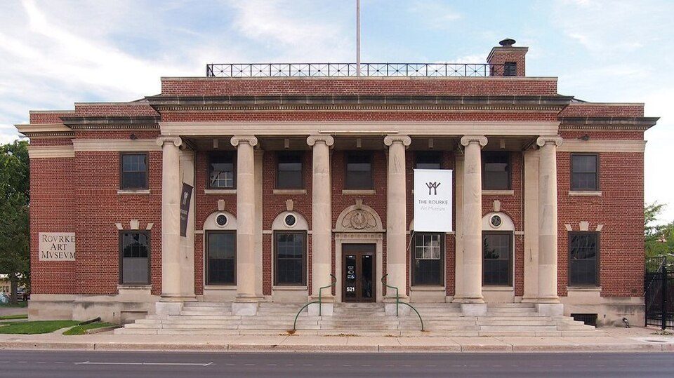 6 mi MuseumRourke Art Museum
Fargodome: Bobak Ha'Eri, CC BY 3.0 · Plains Art Museum: AJ LEON, CC BY 2.0 · Red River Zoo: BrielleMary, CC BY-SA 4.0 · Bonanzaville, USA: Fargo-Moorhead CVB, CC BY-SA 2.0 · Fargo Air Museum: Fargo-Moorhead CVB, CC BY-SA 2.0 · Rourke Art Museum: McGhiever, CC BY-SA 3.0
4 within 15 miles of the center of West Fargo
About 7 of every 100 West Fargo residents are enrolled in college, about the same as North Dakota.
4 notable people were born in West Fargo.
City in North Dakota, United States
West Fargo is a city in Cass County, North Dakota, United States. West Fargo is classified as the western neighboring city of Fargo. The population was 38,626 at the 2020 census, and was estimated at 41,027 in 2024, making it the fifth-most populous city in North Dakota. It is part of the Fargo–Moorhead, ND-MN metropolitan area. It is one of the state's fastest growing cities.
From Wikipedia, licensed CC BY-SA 4.0 · facts via Wikidata (CC0)
6 towns share a border with West Fargo.
| Town | ND rank | Overall | Cost | Safety | Schools | Health |
|---|---|---|---|---|---|---|
| West Fargo | #7 | B+ | C | B− | B− | A |
| Fargo | #18 | C+ | C+ | D | B− | A |
| Mapleton Township | — | — | — | — | — | — |
| Barnes Township | — | — | — | — | — | — |
| Reed Township | — | — | C+ | — | B− | A |
| Raymond Township | — | — | — | — | — | — |
| Horace | #11 | B | C− | — | B− | A |
Reed Township has fewer than 2,500 residents, so it gets subject grades but no overall grade. Reed Township and Horace report no FBI crime data of their own. Mapleton Township, Barnes Township and Raymond Township aren’t graded (fewer than 1,000 residents, or not enough data). Compare West Fargo with a neighbor →
Short answers, built from the data on this page.
By most measures, yes. West Fargo grades B+ overall, better than 69% of U.S. towns and #7 of 23 in North Dakota. It grades A for health, B− for safety and B− for schools.
Cost of living, which also weighs rents, property taxes and how many households pay 30% or more of their income for housing, grades C.
4 notable people were born here, including Matt Strahm and Andy Young.


