Natchez dates to 1716, and 17% of its homes were built before 1940
More historic than 96% of U.S. towns · #1 of 100 in Mississippi. What drives it
82 places in town are on the National Register, among them 11 National Historic Landmarks and nine historic districts with 1,398 buildings between them. Below: 2 old photos and papers, maps from 1886 on, and the census since 1810.
Founding year: Wikidata. First post office: 1799.The full story ↓
History grade
What drives Natchez’s History grade
On its age, its old homes and the National Register, Natchez is more historic than 96% of U.S. towns, #1 of 100 in Mississippi. All 3 inputs are above most U.S. towns; its National Register listings ranks highest and its share of homes from before 1940 lowest.
A+
HistoryA character grade: shown, never part of Natchez’s overall grade.
Mississippi towns list more on the Register than most of the country (a typical Mississippi town has 71.9 per 10,000 residents, the U.S. 2.4), so Natchez’s 1,054 sits above most of its state (97% of Mississippi towns have fewer) while its 1,496 historic buildings outnumber those of 99% of U.S. towns.
NoteThe founding year comes from Wikidata alone; no second source gives 1716.
How sure. Graded on any two of the three inputs instead, the letter would range from A to A+. The pre-1940 share (±2.9 points) is firm at this size.
Founding year: Wikidata (other dates in Quick answers). Homes: Census ACS 2020–24. National Register: National Park Service, May 2026 list; each listing counted once (boundary changes and added documentation belong to their listing), and a historic district counts its contributing buildings. How TownRatings grades history →
What stands out about Natchez’s past
Read from the archive, the National Register and the record. The page puts what stands out first.
The country’s official list of buildings and places worth saving. 11 are National Historic Landmarks, the highest tier. Boundary changes and added documentation are counted with their listing.
Established by French colonists in 1716, Natchez is one of the oldest and most important European settlements in the lower Mississippi River Valley. After the French lost the French and Indian War (Seven Years' War), they ceded Natchez and the surrounding territory to Great Britain in the Treaty of Paris of 1763. (It later traded other territory east of the Mississippi River with Great Britain, which expanded what it called West Florida.) The British Crown bestowed land grants in this territory to officers who had served with distinction in the war. These officers came mostly from the colonies of New York, New Jersey, and Pennsylvania. They established plantations and brought their upper-class lifestyle to the area.
Passages that mention Natchez, cut from the printed page as they were published.
History of the Choctaw, Chickasaw and Natchez Indians1899 · page 537Read the page →
Read the text
But alas for the poor Natchez! An evil day brought the pale-faces among them in the year 1716, who built the fort Rosalie among them and in it garrisoned, as a matter of course, a body of soldiery as a protection in their intended aggressions upon and usurpations of the Indians' rights; -and from that day the sun of the Natchez's happiness began to wane, but to speedily set forever in the oblivion of utter extermination. As an introduction, Cadillac, on his way up
Text read by machine from the scan; it may contain errors.
History of the Choctaw, Chickasaw and Natchez Indians1899 · page 482Read the page →
Read the text
"sine qua non" as the point of rendezvous for the rough and care-for-nothingf men who navigated the keel and flat-boats on the Mississippi river ere they were superseded by the steamboat. At that early day the city of Natchez was an excellent market for the products of the "upper country," consequently hundreds of heavily and richly-laden boats often congregated there, to the great dread of the law-abiding and peaceful inhabitants residiqg in the upper part of
Text read by machine from the scan; it may contain errors.
citizens to whom he made this report. The Palladium, ever reliable but sometimes late, in its issue of September 8, 1803, says: "By a gentleman from Natchez, we are informed that about the 25th or 26th of July, a man by the name of James May, came to Hunston, near Natchez, and made oath before a magistrate, that sundry articles of property and money, which he then delivered up, he
Text read by machine from the scan; it may contain errors.
Scans and text from the Internet Archive. Books published in 1930 or earlier, which are in the public domain.
Timeline
Natchez, 1716 to 1974
Woven from the archive, old maps, post office records, the National Register and the people born here.
Every edition of the U.S. Geological Survey’s map of Natchez. Tap a year, or press play to watch the town change.
1922Natchez sheet · 1:62,500
U.S. Geological Survey historical topographic maps (public domain), via Esri’s collection of the scans. The red ring marks the center of Natchez.
Every building
Natchez, building by building, 1886–1910
Fire insurance maps drew every building, what it was made of and what it was used for, so insurers could price the risk of fire. Pick a year, then a sheet.
In 1716, according to Wikidata. Natchez’s post office opened in 1799, and the census of 1810 counted 1,511 people here.
How does Natchez rank for history?
Natchez is more historic than 96% of U.S. towns, #1 of 100 in Mississippi. The History grade combines the town’s founding era, the share of homes built before 1940 and its National Register listings. It’s a character grade, so it isn’t part of the overall grade. How it works.
What is on the National Register in Natchez?
82 listings, 11 of them National Historic Landmarks: 71 buildings, 9 historic districts with 1,398 contributing buildings, and 2 sites. 1,496 historic buildings in all.
How old are the homes in Natchez?
17% of Natchez’s homes were built before 1940 (Census estimate, ±2.9 points), against a typical 4.5% for a Mississippi town; the median home was built in 1964.
Founding dates: Wikidata, Wikipedia, the U.S. post office records of Blevins & Helbock (CC0) and the Census. Homes by year built: Census ACS 2020–24. National Register of Historic Places: National Park Service (list of May 22, 2026). Old photos, postcards and papers: Wikimedia Commons, the Library of Congress and other public archives, credited on each item’s page. Maps: U.S. Geological Survey historical topographic maps (via Esri) and Sanborn fire-insurance maps (Library of Congress). History text and census tables: Wikipedia (CC BY-SA 4.0). Places that used to be: USGS Geographic Names Information System (2021).
From Wikimedia Commons (2), Wikidata (4), the National Register of Historic Places (82), Wikipedia, Wikidata and Wikipedia for famous people, U.S. Geological Survey historical maps, U.S. Census counts (via Wikipedia), the US Post Offices dataset (Blevins & Helbock), the USGS Geographic Names Information System, Sanborn fire insurance maps (Library of Congress) and old county and town histories (Internet Archive). Archive images are copied here with their credits and licenses, shown on each photo’s page. Refreshed monthly.


 ★ Landmark
 ★ Landmark
 ★ Landmark
 ★ Landmark
 ★ Landmark
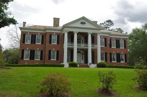 ★ Landmark
 ★ Landmark
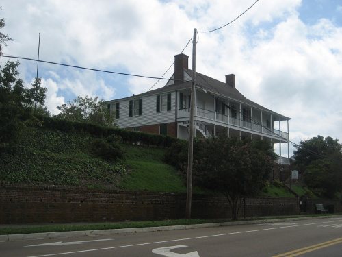 ★ Landmark


