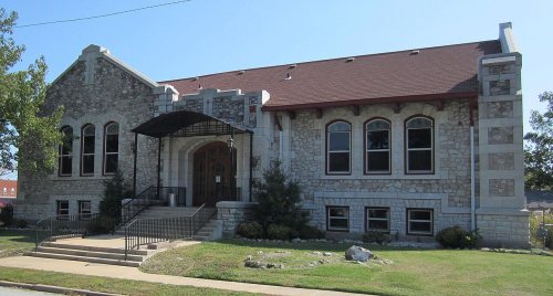
Webb City’s post office opened in 1876, and 17% of its homes were built before 1940
More historic than 70% of U.S. towns · #67 of 247 in Missouri. What drives it
3 places in town are on the National Register, among them a historic district with 43 buildings. Below: 2 old photos and papers, maps from 1885 on, and the census since 1880.
Founding year: the first Webb City post office (Blevins & Helbock, CC0).The full story ↓
History grade
What drives Webb City’s History grade
On its age, its old homes and the National Register, Webb City is more historic than 70% of U.S. towns, #67 of 247 in Missouri. Its National Register listings hold the grade up; its age pulls it down.
B+
HistoryA character grade: shown, never part of Webb City’s overall grade.
Missouri towns list about as much on the Register as the country (a typical Missouri town has 2.4 per 10,000 residents, the U.S. 2.4), so Webb City’s 34.0 sits above most of its state (85% of Missouri towns have fewer) while its 45 historic buildings outnumber those of 84% of U.S. towns.
How sure. Graded on any two of the three inputs instead, the letter would range from B− to A−. The pre-1940 share is a Census survey estimate (±4.4 points). The founding year is the first post office, not a stated founding date.
Founding year: the first post office (other dates in Quick answers). Homes: Census ACS 2020–24. National Register: National Park Service, May 2026 list; each listing counted once (boundary changes and added documentation belong to their listing), and a historic district counts its contributing buildings. How TownRatings grades history →
What stands out about Webb City’s past
Read from the archive, the National Register and the record. The page puts what stands out first.
Every edition of the U.S. Geological Survey’s map of Webb City. Tap a year, or press play to watch the town change.
1886Carthage sheet · 1:125,000
U.S. Geological Survey historical topographic maps (public domain), via Esri’s collection of the scans. The red ring marks the center of Webb City.
Every building
Webb City, building by building, 1885–1915
Fire insurance maps drew every building, what it was made of and what it was used for, so insurers could price the risk of fire. Pick a year, then a sheet.
1885Sheet 1 of 1
Edition
Sheets
BrickWoodStone
Sanborn Map Company, via the Library of Congress. Editions published in 1930 or earlier, which are in the public domain.
Webb City (Webbville) was platted by John C. Webb in September 1875 and incorporated in December 1876, with a population of 700. The city was located on a portion of Webb's 200-acre farm, which he entered in February 1857. There, in 1873, Webb discovered lead while plowing. With the assistance of W.A. Daugherty, he sank the first pump-shaft in 1874. Webb then leased his land to Daugherty and G.P. Ashcraft. In 1876, the Center Creek Mining Company leased the land and began operations. Some 20 years later, 700 mines were located within the limits of Webb City and adjacent Carterville, and the district ranked first in the production of zinc ore.
Passages that mention Webb City, cut from the printed page as they were published.
The history of Jasper county, Missouri1883 · page 608Read the page →
Read the text
Webb City. — The beautiful and flourishing town of Webb City is located about midway between the cities of Joplin and Carthage, in Jasper county. Mo., on the lines of the St. Louis & San Francisco, the Missouri Pacific, and the Kansas City, Fort Scott & Gnlf railways. It was laid out in the summer of 1875 by John C. Webb, who owned tlie land upon which the city is built. The principal support of the town is the wealth of mineral found in the vicinity. The first discovery of lead was made in June, 1873, by Mr. Webb, while ploughing corn. In October following, he began
Text read by machine from the scan; it may contain errors.
A history of Jasper County, Missouri, and its people1912 · page 328Read the page →
Read the text
In 1889 A. H. Rogers of Springfield built a mule street car line from Webb City to Carterville and operated it until 1893, when he organized the South West Missouri Electric Railway Company, took over the rolling stock, car bam, etc., of the Webb City-Carterville Street Railway Company and built an electric railway from Joplin to Prosperity via Webb City and Carterville. A considerable difficulty was experienced in securing the franchise in Webb City, there being quite a sentiment against an interurban line, many of the merchants feeling that
Text read by machine from the scan; it may contain errors.
A history of Jasper County, Missouri, and its people1912 · page 420Read the page →
Read the text
Newspapers Webb City had, during the decade, four papers which at different times influenced the life of the city and chronicled its daily happenings. The old Webb City Times, the Webb City Star, the Record and the Webb City Register, the last two still the two leading papers of the city. For a portion of the time Jesse Zook was the editor of the Register and his long editorial experience and his expert knowledge of mines and mining made this a most valuable paper.
Text read by machine from the scan; it may contain errors.
The history of Jasper county, Missouri1883 · page 526Read the page →
Read the text
In 1883 the company extended the line to Webb City, a distance of seven miles, and placed this station under his management also. Mr. D. is largely interested in mining operations at Webb City, where he is associated with N. M. Barney in working some of the finest prospects in that camp, and is also interested in other mining prospects in the vicinity of Joplin. He has an elegantly furnished room in the Collins Block, also telegraph and telephone with depot and other points of the city and surrounding towns. He is a member of Ascension Commandery No. 39, Knights Templar, wherein
Text read by machine from the scan; it may contain errors.
Scans and text from the Internet Archive. Books published in 1930 or earlier, which are in the public domain.
Timeline
Webb City, 1876 to 1979
Woven from the archive, old maps, post office records, the National Register and the people born here.
Nothing in the archives for these yearsWeddings on Main Street, storms, parades, school pictures, the old store. If it’s in your family album, it belongs here.
Nothing in the archives for these yearsWeddings on Main Street, storms, parades, school pictures, the old store. If it’s in your family album, it belongs here.
The Webb City post office opened in 1876, the earliest record of the town by name (U.S. post office records).
How does Webb City rank for history?
Webb City is more historic than 70% of U.S. towns, #67 of 247 in Missouri. The History grade combines the town’s founding era, the share of homes built before 1940 and its National Register listings. It’s a character grade, so it isn’t part of the overall grade. How it works.
What is on the National Register in Webb City?
Three places: the Middle West Hotel (listed 1982), the Downtown Webb City Historic District (2014) and the Elijah Thomas Webb House (2020).
How old are the homes in Webb City?
17% of Webb City’s homes were built before 1940 (Census estimate, ±4.4 points), against a typical 8.4% for a Missouri town; the median home was built in 1982.
Founding dates: Wikidata, Wikipedia, the U.S. post office records of Blevins & Helbock (CC0) and the Census. Homes by year built: Census ACS 2020–24. National Register of Historic Places: National Park Service (list of May 22, 2026). Old photos, postcards and papers: Wikimedia Commons, the Library of Congress and other public archives, credited on each item’s page. Maps: U.S. Geological Survey historical topographic maps (via Esri) and Sanborn fire-insurance maps (Library of Congress). History text and census tables: Wikipedia (CC BY-SA 4.0). Places that used to be: USGS Geographic Names Information System (2021).
From Wikimedia Commons (8), Wikidata (1), the National Register of Historic Places (3), Wikipedia, Wikidata and Wikipedia for famous people, U.S. Geological Survey historical maps, U.S. Census counts (via Wikipedia), the US Post Offices dataset (Blevins & Helbock), the USGS Geographic Names Information System, Sanborn fire insurance maps (Library of Congress) and old county and town histories (Internet Archive). Archive images are copied here with their credits and licenses, shown on each photo’s page. Refreshed monthly.


 2025
 2023
 2023
 2021
 2010
 2009