Sedalia dates to 1857, and 21% of its homes were built before 1940
More historic than 78% of U.S. towns · #46 of 247 in Missouri. What drives it
15 places in town are on the National Register, among them two historic districts with 168 buildings between them. Below: 6 old photos and papers, maps from 1883 on, and the census since 1870.
Founding year: Wikidata. First post office: 1861.The full story ↓
History grade
What drives Sedalia’s History grade
On its age, its old homes and the National Register, Sedalia is more historic than 78% of U.S. towns, #46 of 247 in Missouri. Its National Register listings hold the grade up; its age pulls it down.
A−
HistoryA character grade: shown, never part of Sedalia’s overall grade.
Missouri towns list about as much on the Register as the country (a typical Missouri town has 2.4 per 10,000 residents, the U.S. 2.4), so Sedalia’s 85.0 sits above most of its state (91% of Missouri towns have fewer) while its 187 historic buildings outnumber those of 93% of U.S. towns.
How sure. Graded on any two of the three inputs instead, the letter would range from B− to A. The pre-1940 share (±2.4 points) is firm at this size. Two sources give 1857.
Founding year: Wikidata (other dates in Quick answers). Homes: Census ACS 2020–24. National Register: National Park Service, May 2026 list; each listing counted once (boundary changes and added documentation belong to their listing), and a historic district counts its contributing buildings. How TownRatings grades history →
What stands out about Sedalia’s past
Read from the archive, the National Register and the record. The page puts what stands out first.
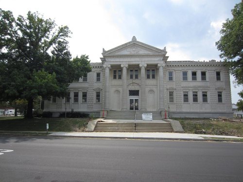
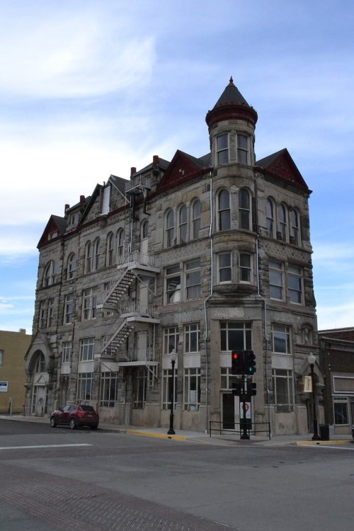
National Park Service, National Register of Historic Places. Photos from Wikimedia Commons, credited on each place’s page.
Every building
Sedalia, building by building, 1883–1914
Fire insurance maps drew every building, what it was made of and what it was used for, so insurers could price the risk of fire. Pick a year, then a sheet.
Native American Indian tribes lived along the Missouri River and its tributaries for thousands of years before European contact. Historians believe the entire area around Sedalia was long occupied by the Osage people. When the land was first settled by European Americans, bands of Shawnee, who had been driven west from east of the Mississippi River, lived in the vicinity of Sedalia.
The area that became Sedalia was founded by General George Rappeen Smith (1804–1879), who also founded nearby Smithton, Missouri. He filed plans for the official record on November 30, 1857, and gave the area the name Sedville. The original plat included the land from today's Missouri Pacific Railroad south to Third Street.
Passages that mention Sedalia, cut from the printed page as they were published.
History of Pettis County, Missouri1919 · page 515Read the page →
Read the text
Mr. Dow taught school for one term in Brown County, Ohio, and was for two years engaged in merchandising in Darke county, Ohio. After his marriage he sold his store and in 1869 came west to Sedalia. Upon his arrival in the new and booming town of Sedalia he found every avenue of business so crowded that he was compelled for his own good to make other plans than a mercantile career in Sedalia. He arrived in Sedalia on New Year’s day and after a careful survey of the situation he deemed it the better policy to go out in the country where things were
Text read by machine from the scan; it may contain errors.
History of Pettis County, Missouri1919 · page 692Read the page →
Read the text
Prairie, Missouri, for a time, when he engaged in saw-mill work and sawed timber for the construction of the Tipton and Versailles railroad. He operated a saw-mill at Hawk Creek, Morgan County, for a time. In 1874, he came to Sedalia and here he built a residence and for a time clerked in a grocery store. He then bought a saw-mill west of Sedalia which he operated for a time when he bought a farm five miles north of Sedalia, which was quite heavily timbered. Here he erected a saw¬ mill which he operated for a time and after clearing up his farm, he
Text read by machine from the scan; it may contain errors.
The History of Pettis County, Missouri, including an authentic history of Sedalia, other towns and townships, together with ... biographical sketches ..1882 · page 515Read the page →
Read the text
From Sedalia to St. Louis by the Missouri Pacific Railroad the distance is 189 miles; from Sedalia to Kansas City, ninety-one miles; from Sedalia to Lexington and the Missouri, fifty-two miles; from Sedalia to Hannibal and the Mississippi River, 143 miles; from Sedalia to Chicago, 366 miles; from Sedalia to Denison, Texas, 433 miles.
Text read by machine from the scan; it may contain errors.
The History of Pettis County, Missouri, including an authentic history of Sedalia, other towns and townships, together with ... biographical sketches ..1882 · page 407Read the page →
Read the text
brought from Georgetown on wagons, and just as soon as a man could get anything to protect goods, that would pass muster for a house, he began business. In 1861, just before the railroad got to Sedalia, the supplies for the Southwest Expedition were brought by rail to Smithton, and that was about the last time that it had, what would be called in the expressive slang of the present day, " a business boom." As soon as the railroad reached Sedalia it became at once the depot of the Overland Stage Line and the headquarters for supplies, as the other towns where the line had
Text read by machine from the scan; it may contain errors.
Scans and text from the Internet Archive. Books published in 1930 or earlier, which are in the public domain.
Timeline
Sedalia, 1857 to 1993
Woven from the archive, old maps, post office records, the National Register and the people born here.
In 1857, according to Wikidata. Sedalia’s post office opened in 1861, and the census of 1870 counted 4,560 people here.
How does Sedalia rank for history?
Sedalia is more historic than 78% of U.S. towns, #46 of 247 in Missouri. The History grade combines the town’s founding era, the share of homes built before 1940 and its National Register listings. It’s a character grade, so it isn’t part of the overall grade. How it works.
What is on the National Register in Sedalia?
15 listings: 13 buildings, among them the Missouri, Kansas and Texas Railroad Depot (listed 1979, the first), and 2 historic districts, the Missouri State Fairgrounds Historic District and the Sedalia Commercial Historic District, with 168 contributing buildings. 187 historic buildings in all.
How old are the homes in Sedalia?
21% of Sedalia’s homes were built before 1940 (Census estimate, ±2.4 points), against a typical 8.4% for a Missouri town; the median home was built in 1964.
Founding dates: Wikidata, Wikipedia, the U.S. post office records of Blevins & Helbock (CC0) and the Census. Homes by year built: Census ACS 2020–24. National Register of Historic Places: National Park Service (list of May 22, 2026). Old photos, postcards and papers: Wikimedia Commons, the Library of Congress and other public archives, credited on each item’s page. Maps: U.S. Geological Survey historical topographic maps (via Esri) and Sanborn fire-insurance maps (Library of Congress). History text and census tables: Wikipedia (CC BY-SA 4.0). Places that used to be: USGS Geographic Names Information System (2021).
From Wikimedia Commons (6), the National Register of Historic Places (15), Wikipedia, Wikidata and Wikipedia for famous people, U.S. Geological Survey historical maps, U.S. Census counts (via Wikipedia), the US Post Offices dataset (Blevins & Helbock), the USGS Geographic Names Information System, Sanborn fire insurance maps (Library of Congress) and old county and town histories (Internet Archive). Archive images are copied here with their credits and licenses, shown on each photo’s page. Refreshed monthly.





 1861
 1862
 1862
 1862
 1862


