176 years in pictures
Census counts: 791 in 1880, 16,225 in 2020. The archive holds 18 old photos and papers going back to 1891 and 3 maps from 1935 on.
21 places on the National Register of Historic Places.
- 1850Poplar Bluff is settled
Each edition grades its towns against each other only.

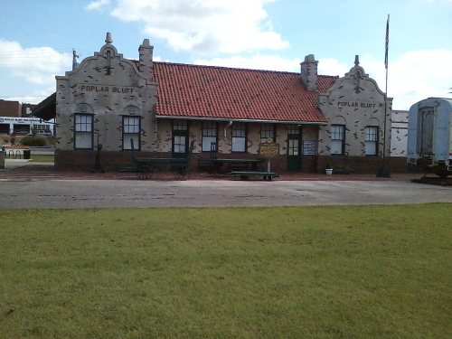
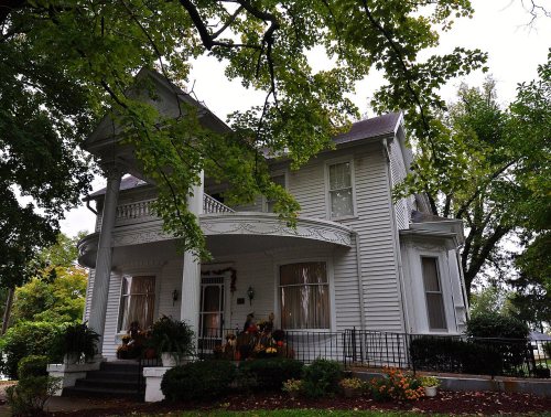
Residents are less healthy than 98% of U.S. towns on CDC estimates. Overall it grades C−, ranked 191st of 247 in Missouri. Its weakest subject is hazard risk: FEMA rates its natural-hazard risk higher than 85% of U.S. communities, with earthquakes at the top. 50% of working residents work locally in Poplar Bluff, above both the Missouri town median (13%) and the median of U.S. towns (8%). Its National Register listings include St. Louis-San Francisco Railroad Depot and Moore-Dalton House. Only 6 of the 170 Missouri towns we compare have a higher property crime rate than Poplar Bluff.
Where Poplar Bluff beats most towns, and one thing worth knowing.
Butler County Courthouse| Widest gap | Poplar Bluff | MO |
|---|---|---|
| More older adults who have lost all their teeth | 29.3% | 15.8% |
Census counts: 791 in 1880, 16,225 in 2020. The archive holds 18 old photos and papers going back to 1891 and 3 maps from 1935 on.
21 places on the National Register of Historic Places.
Each subject compared with towns across the country (schools within Missouri), ordered by how far Poplar Bluff is from typical.
How TownRatings grades towns →
Who provides power, water and the rest in Poplar Bluff, and how to reach them.
EPA SDWIS (Oct 9, 2026) · HIFLD + EIA-861 2025 · Census 2020 ZCTAs · NCES 2024–25 · registration: vote.gov, updated Nov 18, 2024.
Ordered by what stands out in Poplar Bluff.
Poplar Bluff draws workers from Cape Girardeau and beyond, but it carries more natural-hazard risk than most of Missouri (mostly earthquakes) and has household incomes well below the Missouri norm.
22 miles of trail in 6 parks and preserves. Poplar Bluff’s trail density is 1.6 miles per square mile. McLane Park, at 63 acres with 1.2 miles of trail, is the biggest park or preserve.
| Poplar Bluff | Missouri towns | U.S. towns | |
|---|---|---|---|
| Miles of trail per square mile | 1.6 miles per square mile | 0.3 | 0.4 |
| Conserved land | 1.7% | 2.1% | 4.3% |
| Biggest places to walk | Trails | Acres |
|---|---|---|
| 1. McLane Park | 1.2 mi | 63 |
| 2. Bacon Memorial Park | 0.7 mi | 30 |
| 3. Whiteley Park | 0.2 mi | 31 |
Trails & parks © OpenStreetMap contributors · Conserved land: USGS PAD-US
Its public schools are run by the Poplar Bluff R-I school district. Three of its 12 schools are below, each with why it’s listed.
| School | Level | Students | Letter |
|---|---|---|---|
| Poplar Bluff Middle SchoolLargest public middle schoolGrades 4–6 | Grades 4–6 | 932 | B− |
| Poplar Bluff HighLargest public high schoolGrades 9–12 | Grades 9–12 | 1,416 | C |
| Eugene Field Elem.Top results in townGrades 1–3 | Grades 1–3 | 227 | A+ |
NCES · EDFacts · graded within MO on state tests and graduation
20% of adults report frequent physical distress in Poplar Bluff. Only 8 of the 247 Missouri towns we compare have a higher share of adults who report frequent mental distress than Poplar Bluff. 32% of adults say their health is fair or poor in Poplar Bluff.
| Poplar Bluff | Missouri towns | U.S. towns | |
|---|---|---|---|
| Smoke cigarettes (CDC PLACES) | 24% | 17% | 14% |
| Frequent physical distress (CDC PLACES) | 20% | 15% | 14% |
| Get no exercise (CDC PLACES) | 41% | 30% | 25% |
| Fair or poor health (CDC PLACES) | 32% | 22% | 19% |
| What stands out | Poplar Bluff | MO |
|---|---|---|
| More older adults who have lost all their teeth | 29.3% | 15.8% |
| More adults facing food insecurity | 25.3% | 13.7% |
| More adults facing a utility shut-off | 15.1% | 9% |
CDC PLACES 2025 · modeled estimates for adults · CMS · HRSA
13,458 jobs are based in Poplar Bluff, 2.2 for every working resident, so most of the people who work here commute in.
21% of Poplar Bluff residents live below the poverty line. The top destinations are Cape Girardeau (3%), Dexter (2%) and Sikeston (2%). The average trip to work in Poplar Bluff is 18 minutes.
| Poplar Bluff | Missouri towns | U.S. towns | |
|---|---|---|---|
| Below the poverty line | 21% | 14% | 9.6% |
| Average trip to work | 18 minutes | 22 minutes | 25 minutes |
| Work from home | 3.7% | 9% | 11% |
| Median household income | $42,000 | $62,000 | $80,000 |
Census LEHD 2023 · ACS
FEMA rates its natural-hazard risk higher than 95% of Missouri towns, with expected losses of about $951 per resident a year; that rating is what its D for hazard risk is built on. 126 flood insurance claims have been filed here, and 17 properties have flooded more than once.
Since 1979, 126 flood insurance claims have been paid out in Poplar Bluff.
FEMA flood insurance claims · FEMA National Risk Index · OpenFEMA
The median property tax bill is $796, against $1,948 across Missouri, another input to its cost-of-living grade.
The typical Poplar Bluff home is worth about $176,000, up 9.9% in a year, 34% below the Missouri typical home.
| Poplar Bluff | Missouri towns | U.S. towns | |
|---|---|---|---|
| Households that own their home | 53% | 64% | 73% |
| Median rent | $760 a month | $972 a month | $1,185 a month |
Zillow Home Value Index · Redfin Data Center
Poplar Bluff has chilly winters and warm summers, with plenty of rain. July afternoons reach 90°, January nights drop to 26° and about 5 inches of snow falls in a winter.
NOAA U.S. Climate Normals, 1991–2020
Poplar Bluff's reported crime rate is well above Missouri's. Only 9 of the 170 Missouri towns we compare have a higher violent crime rate than Poplar Bluff. Most reported incidents are property crimes, mainly thefts.
FBI crime data, 2025 · crimes reported to police
1 within 15 miles of the center of Poplar Bluff
About 3 of every 100 Poplar Bluff residents are enrolled in college, against 6 across Missouri.
21 places in Poplar Bluff on the National Register of Historic Places.
18 notable people were born in Poplar Bluff.

City in Missouri, U.S.
Poplar Bluff is a city in and the county seat of Butler County, Missouri, United States, that is known as "The Gateway to the Ozarks" among other names. The population was 16,225 at the 2020 census. The Poplar Bluff Micropolitan Statistical Area consists of all of Butler County. The city is at the crossroads of U.S. Route 60 and U.S. Route 67.
From Wikipedia, licensed CC BY-SA 4.0 · facts via Wikidata (CC0)
Short answers, built from the data on this page.
Poplar Bluff grades C− overall, better than 19% of U.S. towns and #191 of 247 in Missouri. It grades D− for health and B+ for schools. Health is its weak spot, with a D−.
That is 3.6 years of the area's median household income ($49,089 across the Poplar Bluff, MO area). Cost of living, which also weighs rents, property taxes and how many households pay 30% or more of their income for housing, grades B.
18 notable people were born here, including Scott Innes and Ben Hansbrough.