Mexico dates to 1836, and 21% of its homes were built before 1940
More historic than 86% of U.S. towns · #27 of 247 in Missouri. What drives it
3 places in town are on the National Register, among them a historic district with 6 buildings. Below: 8 old photos and papers, maps from 1885 on, and the census since 1860.
Founding year: Wikidata; Wikipedia’s history section gives the same year. First post office: 1837.The full story ↓
History grade
What drives Mexico’s History grade
On its age, its old homes and the National Register, Mexico is more historic than 86% of U.S. towns, #27 of 247 in Missouri. All 3 inputs are above most U.S. towns; its age ranks highest and its National Register listings lowest.
A
HistoryA character grade: shown, never part of Mexico’s overall grade.
Missouri towns list about as much on the Register as the country (a typical Missouri town has 2.4 per 10,000 residents, the U.S. 2.4), so Mexico’s 7.0 sits above most of its state (70% of Missouri towns have fewer) while its 8 historic buildings outnumber those of 74% of U.S. towns.
How sure. Graded on any two of the three inputs instead, the letter would still be A−. The pre-1940 share is a Census survey estimate (±4.5 points). Two sources give 1836.
Founding year: Wikidata (other dates in Quick answers). Homes: Census ACS 2020–24. National Register: National Park Service, May 2026 list; each listing counted once (boundary changes and added documentation belong to their listing), and a historic district counts its contributing buildings. How TownRatings grades history →
What stands out about Mexico’s past
Read from the archive, the National Register and the record. The page puts what stands out first.
Fire insurance maps drew every building, what it was made of and what it was used for, so insurers could price the risk of fire. Pick a year, then a sheet.
Mexico was laid out as "New Mexico" in 1836 and was a major stop for settlers heading to the Republic of Texas (thus the name "New Mexico"), and it became the county seat under its present name in 1837. The word "New" was dropped after the Mexican War that saw Texas become a part of the United States.
numbering three hundred and twenty-five men under General M’Leod, left Austin, the capital of Texas, and after a journey of about three months, arrived at the Spanish settlements in New Mexico. They were intercepted by a vastly superior force, and surrendered on condition of their being allowed to return ; but instead of this, they wTere bound with ropes and leather thongs, in gangs of six or eight, stripped of most of their clothing, and inarched to the city of Mexico, a distance of twelve hundred
Text read by machine from the scan; it may contain errors.
twelve hundred Mexicans, under General Woll, took the town of Bexar, but subsequently retreated beyond the Bio Grande. A Texan army was collected, which was zealous to carry the war into Mexico. After various disappointments and the return of most of the volunteers, three hundred Texans crossed the Bio Grande and attacked the town of Mier, which was garrisoned by more than two thousand Mexicans strongly posted. In a dark, rainy night, they drove in the guard, and in spite of a constant fire of the
Text read by machine from the scan; it may contain errors.
History of Audrain County, Missouri1884 · page 183Read the page →
Read the text
The original town of Mexico was located in the central portion of the north-west quarter of section 26, township 51, range 9, and was laid out in April, 1836, by Robert C. Mansfield and James H. Smith, who entered the land at $1.25 per acre.
Text read by machine from the scan; it may contain errors.
History of Audrain County, Missouri1884 · page 197Read the page →
Read the text
Below we present a review of the business of Mexico for the year 1874. It is important, because it shows the names of the parties who were doing business in Mexico at that time, how long they had been in business, and what their sales amounted to that year. It also gives something of an insight into the character of the men who were then the merchants and tradesmen of Mexico. We copy from the Messen¬ ger of December, 1874 : — We lay before our readers and the general public a very extended
Text read by machine from the scan; it may contain errors.
Scans and text from the Internet Archive. Books published in 1930 or earlier, which are in the public domain.
By decade
Mexico, decade by decade
2 decades in the archive, from the 1860s to the 1910s. Scroll each row; tap a photo for its story.
Nothing in the archives for these yearsWeddings on Main Street, storms, parades, school pictures, the old store. If it’s in your family album, it belongs here.
In 1836, according to Wikidata and Wikipedia’s history of the town. Mexico’s post office opened in 1837, and the census of 1860 counted 960 people here.
How does Mexico rank for history?
Mexico is more historic than 86% of U.S. towns, #27 of 247 in Missouri. The History grade combines the town’s founding era, the share of homes built before 1940 and its National Register listings. It’s a character grade, so it isn’t part of the overall grade. How it works.
What is on the National Register in Mexico?
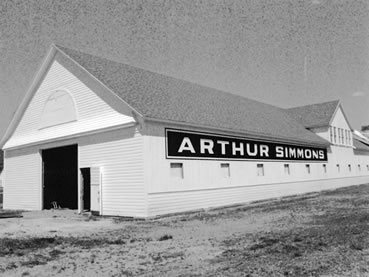
Three places: the Ross House (listed 1978), the Simmons, Arthur, Stables Historic District (2004) and the Audrain County Courthouse (2012).
How old are the homes in Mexico?
21% of Mexico’s homes were built before 1940 (Census estimate, ±4.5 points), against a typical 8.4% for a Missouri town; the median home was built in 1965.
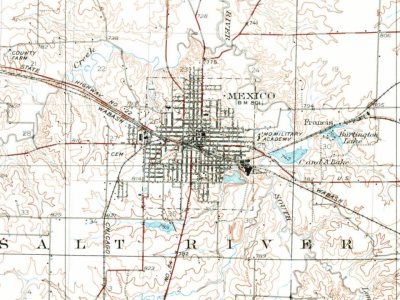
Founding dates: Wikidata, Wikipedia, the U.S. post office records of Blevins & Helbock (CC0) and the Census. Homes by year built: Census ACS 2020–24. National Register of Historic Places: National Park Service (list of May 22, 2026). Old photos, postcards and papers: Wikimedia Commons, the Library of Congress and other public archives, credited on each item’s page. Maps: U.S. Geological Survey historical topographic maps (via Esri) and Sanborn fire-insurance maps (Library of Congress). History text and census tables: Wikipedia (CC BY-SA 4.0). Places that used to be: USGS Geographic Names Information System (2021).
From Wikimedia Commons (6), the Library of Congress (7), the National Register of Historic Places (3), Wikipedia, U.S. Geological Survey historical maps, U.S. Census counts (via Wikipedia), the US Post Offices dataset (Blevins & Helbock), the USGS Geographic Names Information System, Sanborn fire insurance maps (Library of Congress) and old county and town histories (Internet Archive). Archive images are copied here with their credits and licenses, shown on each photo’s page. Refreshed monthly.




 1910
 1910
 1910
 1910
 1910
 1912
 2026
 2026
 2015
 2011
 2007


