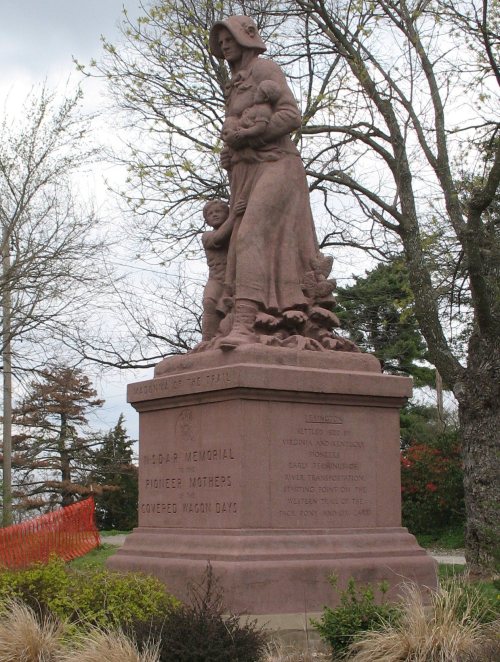
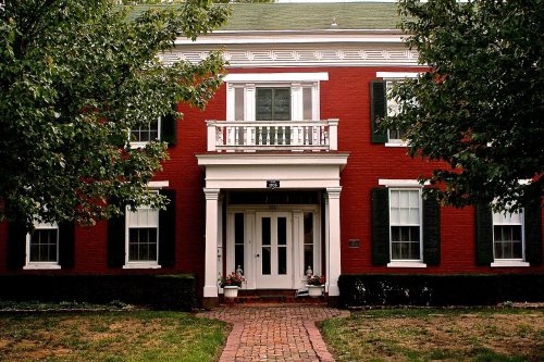
Lexington dates to 1822, and 16% of its homes were built before 1940
More historic than 91% of U.S. towns · #10 of 247 in Missouri. What drives it
23 places in town are on the National Register, among them five historic districts with 444 buildings between them. Below: 2 old photos and papers, maps from 1885 on, and the census since 1850.
Founding year: Wikidata; Wikipedia’s history section gives the same year. First post office: 1831. Name: Wikipedia, licensed CC BY-SA 4.0.The full story ↓
History grade
What drives Lexington’s History grade
On its age, its old homes and the National Register, Lexington is more historic than 91% of U.S. towns, #10 of 247 in Missouri. All 3 inputs are above most U.S. towns; its National Register listings ranks highest and its share of homes from before 1940 lowest.
A
HistoryA character grade: shown, never part of Lexington’s overall grade.
Missouri towns list about as much on the Register as the country (a typical Missouri town has 2.4 per 10,000 residents, the U.S. 2.4), so Lexington’s 1,029 sits above most of its state (99% of Missouri towns have fewer) while its 474 historic buildings outnumber those of 97% of U.S. towns.
How sure. Graded on any two of the three inputs instead, the letter would range from B+ to A+. The pre-1940 share is a Census survey estimate (±6.8 points). Two sources give 1822.
Founding year: Wikidata (other dates in Quick answers). Homes: Census ACS 2020–24. National Register: National Park Service, May 2026 list; each listing counted once (boundary changes and added documentation belong to their listing), and a historic district counts its contributing buildings. How TownRatings grades history →
What stands out about Lexington’s past
Read from the archive, the National Register and the record. The page puts what stands out first.
Lexington is located on the bluffs of the Missouri River. It was platted in 1822 near William Jack's Ferry, which had been established three years earlier on the south bank of the river. It was named in commemoration of the Battle of Lexington. The first ferry was established in 1819 by Lexington's founder, Gilead Rupe. In 1823, Lexington became the county seat of Lafayette County and grew rapidly.
John Aull opened a mercantile store in 1822, and he was soon joined by his brothers James and Robert. The Aull Brothers firm soon had a frontier chain, also operating stores in Independence, Westport and Liberty. Other merchants came, as did farmers and planters who specialized in hemp, tobacco and cattle.
Passages that mention Lexington, cut from the printed page as they were published.
History of Lafayette county, Mo. , carefully written and compiled from the most authentic official and private sources, including a history of its townships, cities, towns, and villages, together with a condensed history of Missouri1881 · page 312Read the page →
Read the text
court recorded this — " Additional Order in relation to the proposed railroad subscription. It is hereby further ordered that this court will not be bound to make any subscription to a railroad from Lexington to the Pacific railroad until there is an act of the Legislature passed that will make the tax levied for railroad purposes applicable to all taxable property in the city of Lexington and all incorporated towns in the county of Lafayette, any law to the contrary notwithstanding that exempts the property within the county of
Text read by machine from the scan; it may contain errors.
Young's history of Lafayette County, Missouri1910Read the page →
Read the text
In January, 1839, the first church house, a frame building, built in Lexington on lot No. 73, original town of Lexington. The deed of conveyance for said lot is dated January 17, 1839, and the church was built jointly by the Presbyterian church and the Cumberland Presbyterian church.
Text read by machine from the scan; it may contain errors.
History of Lafayette county, Mo. , carefully written and compiled from the most authentic official and private sources, including a history of its townships, cities, towns, and villages, together with a condensed history of Missouri1881 · page 221Read the page →
Read the text
Whether the railroad company considered these results such as to warrant them in ever building a railroad bridge at Lexington, no man knoweth; but at this writing (Oct. 1, 1881) there are many signs which seem to indicate that a bridge will sometime be built here, and that the Chicago, Burlington and Quincy railroad company will run its southwestern branch from Burlington, Iowa, by way of the old Lexington and Gulf grade toward Texas.
Text read by machine from the scan; it may contain errors.
Young's history of Lafayette County, Missouri1910Read the page →
Read the text
This church was sold in 1880 to the Lexington German School Association and the congregation built a frame building three miles south of Lexington, known as the Edenview church, which is still occupied by the original Lexington congregation. The Cumberland Presbyterians built a large brick building ten miles south of Lexington in 1850, called the Mount Hebron church. This building was twice burned and rebuilt and is now occupied by the Mount Hebron congregation.
Text read by machine from the scan; it may contain errors.
Scans and text from the Internet Archive. Books published in 1930 or earlier, which are in the public domain.
Timeline
Lexington, 1822 to 1949
Woven from the archive, old maps, post office records, the National Register and the people born here.
Every edition of the U.S. Geological Survey’s map of Lexington. Tap a year, or press play to watch the town change.
1949Lexington West sheet · 1:24,000
U.S. Geological Survey historical topographic maps (public domain), via Esri’s collection of the scans. The red ring marks the center of Lexington.
Every building
Lexington, building by building, 1885–1918
Fire insurance maps drew every building, what it was made of and what it was used for, so insurers could price the risk of fire. Pick a year, then a sheet.
US Post Offices dataset (Blevins & Helbock, CC0). Places and cemeteries from the USGS Geographic Names Information System (2021).
Questions about Lexington’s history
What year was Lexington founded?
In 1822, according to Wikidata and Wikipedia’s history of the town. Lexington’s post office opened in 1831, and the census of 1850 counted 2,698 people here.
How does Lexington rank for history?
Lexington is more historic than 91% of U.S. towns, #10 of 247 in Missouri. The History grade combines the town’s founding era, the share of homes built before 1940 and its National Register listings. It’s a character grade, so it isn’t part of the overall grade. How it works.
What is on the National Register in Lexington?
23 listings: 16 buildings, 5 historic districts with 444 contributing buildings, and 2 sites. 474 historic buildings in all.
How old are the homes in Lexington?
16% of Lexington’s homes were built before 1940 (Census estimate, ±6.8 points), against a typical 8.4% for a Missouri town; the median home was built in 1962.
Founding dates: Wikidata, Wikipedia, the U.S. post office records of Blevins & Helbock (CC0) and the Census. Homes by year built: Census ACS 2020–24. National Register of Historic Places: National Park Service (list of May 22, 2026). Old photos, postcards and papers: Wikimedia Commons, the Library of Congress and other public archives, credited on each item’s page. Maps: U.S. Geological Survey historical topographic maps (via Esri) and Sanborn fire-insurance maps (Library of Congress). History text and census tables: Wikipedia (CC BY-SA 4.0). Places that used to be: USGS Geographic Names Information System (2021).
From Wikimedia Commons (2), Wikidata (1), the National Register of Historic Places (23), Wikipedia, Wikidata and Wikipedia for famous people, U.S. Geological Survey historical maps, U.S. Census counts (via Wikipedia), the US Post Offices dataset (Blevins & Helbock), the USGS Geographic Names Information System, Sanborn fire insurance maps (Library of Congress) and old county and town histories (Internet Archive). Archive images are copied here with their credits and licenses, shown on each photo’s page. Refreshed monthly.