Jackson’s post office opened in 1811, and 5 of its places are on the National Register
More historic than 75% of U.S. towns · #56 of 247 in Missouri. What drives it
Most of Jackson was built recently: 7% of its homes predate 1940 and the median home dates from 1991. 5 places in town are on the National Register, among them two historic districts with 27 buildings between them. Below: 2 old photos and papers, maps from 1895 on, and the census since 1860.
Founding year: the first Jackson post office (Blevins & Helbock, CC0).The full story ↓
History grade
What drives Jackson’s History grade
On its age, its old homes and the National Register, Jackson is more historic than 75% of U.S. towns, #56 of 247 in Missouri. Its National Register listings hold the grade up; its share of homes from before 1940 pulls it down.
A−
HistoryA character grade: shown, never part of Jackson’s overall grade.
Missouri towns list about as much on the Register as the country (a typical Missouri town has 2.4 per 10,000 residents, the U.S. 2.4), so Jackson’s 19.2 sits above most of its state (81% of Missouri towns have fewer) while its 30 historic buildings outnumber those of 82% of U.S. towns.
How sure. Graded on any two of the three inputs instead, the letter would range from B to A−. The pre-1940 share (±2.9 points) is firm at this size. The founding year is the first post office, not a stated founding date.
Founding year: the first post office (other dates in Quick answers). Homes: Census ACS 2020–24. National Register: National Park Service, May 2026 list; each listing counted once (boundary changes and added documentation belong to their listing), and a historic district counts its contributing buildings. How TownRatings grades history →
What stands out about Jackson’s past
Read from the archive, the National Register and the record. The page puts what stands out first.
National Park Service, National Register of Historic Places. Photos from Wikimedia Commons, credited on each place’s page.
Every building
Jackson, building by building, 1895–1921
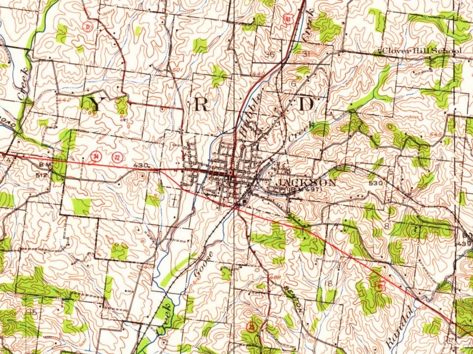
Fire insurance maps drew every building, what it was made of and what it was used for, so insurers could price the risk of fire. Pick a year, then a sheet.
In 1813, Cape Girardeau County succeeded Cape Girardeau District, and the Court of Common Pleas and the Court of General Quarter-Sessions of the Peace in Cape Girardeau were superseded by the Court of Common Pleas, leading to a new seat of justice. The seat of the county and the courts were at first held on the plantation of Thomas Bull about one and one-half mile south of present-day Jackson. Land was then purchased along Hubble Creek for the county seat in 1814.
Passages that mention Jackson, cut from the printed page as they were published.
The History of Jackson county, Missouri, containing a history of the county, its cities, towns, etc., biographical sketches of its citizens, Jackson county in the late war... history of Missouri, map of Jackson county ..1881 · page 68Read the page →
Read the text
Beginning at the south-east corner of Jackson county, for a distance ot six miles Johnson county forms its eastern l?oundary, the remaining 15.57 miles to the Missouri River is the dividing line between Lafayette and Jackson beginning with the north-east corner of Jackson county, the Missouri forms the boundary line between Ray and Jackson for a distance of nine or ten miles, and for the remainder of the distance it separates Jackson and Clay counties. The center of Jackson county is two hundred and seventy miles a little north of west of St.
Text read by machine from the scan; it may contain errors.
The History of Jackson county, Missouri, containing a history of the county, its cities, towns, etc., biographical sketches of its citizens, Jackson county in the late war... history of Missouri, map of Jackson county ..1881 · page 325Read the page →
Read the text
The Presbyterians — Schools — Doctors and Lawyers — Mails and Newspapers — First Township Officers — Lone Jack — Retrospect — The Oldest Man — The Oldest Woman — Physicial Features The township of Van Buren, as now constituted, lies in the southeastern corner of Jackson county; being nine miles north and south, by eight miles east and west. The first organization for municipal purposes was in May, 1834; embracing, in addition to its present territory, the whole of what was called the Big Creek Settlements in Jackson county; which then included, or had jurisdiction of all the territory now included in Jackson, Cass and Bates counties. The Big Creek
Text read by machine from the scan; it may contain errors.
History of Jackson County, Missouri1920 · page 91Read the page →
Read the text
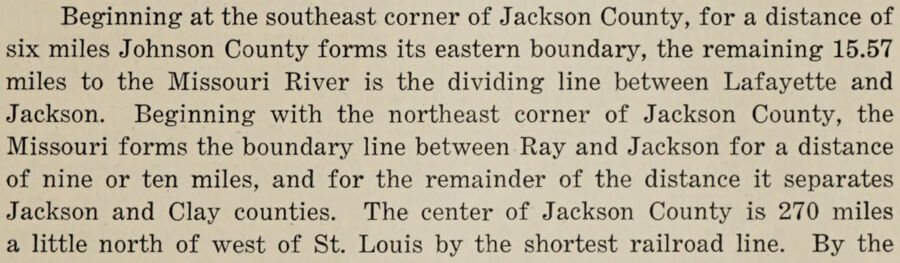
Beginning at the southeast corner of Jackson County, for a distance of six miles Johnson County forms its eastern boundary, the remaining 15.57 miles to the Missouri River is the dividing line between Lafayette and Jackson. Beginning with the northeast corner of Jackson County, the Missouri forms the boundary line between Ray and Jackson for a distance of nine or ten miles, and for the remainder of the distance it separates Jackson and Clay counties. The center of Jackson County is 270 miles a little north of west of St. Louis by the shortest railroad line. By the
Text read by machine from the scan; it may contain errors.
History of Jackson County, Missouri1920 · page 651Read the page →
Read the text
Noel E. Jackson, now living retired at Independence, is one of the veteran pioneer Shorthorn breeders of Jackson County, and during his active career was prominently identified with the agricultural interest of this section of Missouri. He is now the owner of 160 acres of productive farm land in Jackson County, which one of his sons is operating, and he also owns 120 acres in St. Clair County.
Text read by machine from the scan; it may contain errors.
Scans and text from the Internet Archive. Books published in 1930 or earlier, which are in the public domain.
Timeline
Jackson, 1811 to 1999
Woven from the archive, old maps, post office records, the National Register and the people born here.
The Jackson post office opened in 1811, the earliest record of the town by name (U.S. post office records).
How does Jackson rank for history?
Jackson is more historic than 75% of U.S. towns, #56 of 247 in Missouri. The History grade combines the town’s founding era, the share of homes built before 1940 and its National Register listings. It’s a character grade, so it isn’t part of the overall grade. How it works.
What is on the National Register in Jackson?
5 listings: 3 buildings, among them the Bennett-Tobler-Pace-Oliver House (listed 1985, the first), and 2 historic districts, the Jackson Uptown Commercial Historic District and the Big Hill Farmstead Historic District, with 27 contributing buildings. 30 historic buildings in all.
How old are the homes in Jackson?
7% of Jackson’s homes were built before 1940 (Census estimate, ±2.9 points), against a typical 8.4% for a Missouri town; the median home was built in 1991.
Founding dates: Wikidata, Wikipedia, the U.S. post office records of Blevins & Helbock (CC0) and the Census. Homes by year built: Census ACS 2020–24. National Register of Historic Places: National Park Service (list of May 22, 2026). Old photos, postcards and papers: Wikimedia Commons, the Library of Congress and other public archives, credited on each item’s page. Maps: U.S. Geological Survey historical topographic maps (via Esri) and Sanborn fire-insurance maps (Library of Congress). History text and census tables: Wikipedia (CC BY-SA 4.0). Places that used to be: USGS Geographic Names Information System (2021).
From Wikimedia Commons (5), the Library of Congress (2), the National Register of Historic Places (5), Wikipedia, Wikidata and Wikipedia for famous people, U.S. Geological Survey historical maps, U.S. Census counts (via Wikipedia), the US Post Offices dataset (Blevins & Helbock), the USGS Geographic Names Information System, Sanborn fire insurance maps (Library of Congress) and old county and town histories (Internet Archive). Archive images are copied here with their credits and licenses, shown on each photo’s page. Refreshed monthly.





 Date?
 Date?
 2018
 2011
 2009
 2008
 2004