Guest, Sign inJoin

Post to Hume

We’ll email a one-tap link to publish your post. No password, and nothing is public until you click it.
Already a member? Sign in
–Not graded
History · Hume

Hume’s post office opened in 1860, and 21% of its homes were built before 1940

Below: maps from 1916 on and the census since 1890.

1860first post office
0on the National Register
21%homes built before 1940
2famous people
Quick answers

How Hume began

When was Hume founded?

1860

The Hume post office opened in 1860, the earliest record of the town by name. Wikidata gives 1880.

First census: 486 in 18902020 census: 283166 years
Founding year: the first Hume post office (Blevins & Helbock, CC0). Wikidata: 1880.The full story ↓

What stands out about Hume’s past

Read from the archive, the National Register and the record. The page puts what stands out first.

★ What stands out · Help out

Start Hume’s collection

The first neighbors to add old photos shape how Hume’s history is told.

Decades since 1900 with photos
00s10s20s30s40s50s60s70s80s90s
0 of 10 decades. The empty ones are waiting for someone’s album.
People over time

Hume, census by census

01002003004005006001900192019401960198020002020Peak: 595

Peaked at 595 in 1930; 283 people lived here in 2020.

14 censuses, 1890–2020.

U.S. Census Bureau decennial counts, from the census table on Hume’s Wikipedia page.

The story

How Hume came to be

From Wikipedia’s history of Hume.

Read it all →

The Hume area prior to the founding of the town was an area bathed in the beauty of nature and heinous Border Wars. Native Americans are thought to have buried their dead in a mound structure approximately one mile north of Hume, although there is no evidence to support this claim. The first known Euro-American settler in the Hume area was Peter Duncan in 1835. The Bleeding Kansas affair and the upcoming Civil War brought John Brown to this area with an attack on the Lawrence farm, five miles south of Hume, in which slaves were freed. Border warfare fighting began soon after, which cost many lives. The Civil War began in 1861, and within a 40-mile radius of Hume, two battles took place: the Battle of Mine Creek and the Battle of Dry Wood Creek. The war came to a head when Order No. 11 was signed by Gen. Thomas Ewing and led to a burning of settlements in the Hume area.

Text from Wikipedia, licensed CC BY-SA 4.0.

From the old history books

What they wrote about Hume in 1918

Passages that mention Hume, cut from the printed page as they were published.

Hume was platted in the fall of 1880, but it was not until the winter of 1882 that Hume had a school, the children prior to that attending the Greenridge school, one mile south of Hume.
History of Bates County, Missouri1918 · page 214Read the page →
Read the text

Hume was platted in the fall of 1880, but it was not until the winter of 1882 that Hume had a school, the children prior to that attending the Greenridge school, one mile south of Hume.

Text read by machine from the scan; it may contain errors.
of Walnut township and he bought and shipped cattle, driving them to Pleasanton, Kansas, where they were loaded on the train for the city markets. He followed his profession and engaged in cattle raising until his removal to Hume, Missouri, in 1885. He then engaged in bankine and established the Hu…
History of Bates County, Missouri1918Read the page →
Read the text

of Walnut township and he bought and shipped cattle, driving them to Pleasanton, Kansas, where they were loaded on the train for the city markets. He followed his profession and engaged in cattle raising until his removal to Hume, Missouri, in 1885. He then engaged in bankine and established the Hume Bank of which he was cashier and virtual head until the bank was merged with its successor, the Commercial Bank of Hume. Doctor Standish was a large stockholder of this bank. For a number of years he was a breeder of thoroughbred

Text read by machine from the scan; it may contain errors.

Scans and text from the Internet Archive. Books published in 1930 or earlier, which are in the public domain.

Timeline

Hume, 1860 to 1940

Woven from the archive, old maps, post office records, the National Register and the people born here.

  1. 19th century
  2. 1860Post officeThe Hume post office opens
  3. 1897Born hereThelma G. Thurstone is born here
  4. 20th century
  5. 1930CensusPopulation peaks at 595
  6. 1938Born hereHarold Caskey is born here
  7. 1940On the mapFirst mapped by the U.S. Geological Survey
By decade

No old photos in the archives yet

Weddings on Main Street, storms, parades, school pictures, the old store. If it’s in your family album, it belongs here.

Be the first to add onePhotograph a print flat, in daylight, no flash.
Add from your album
On the map

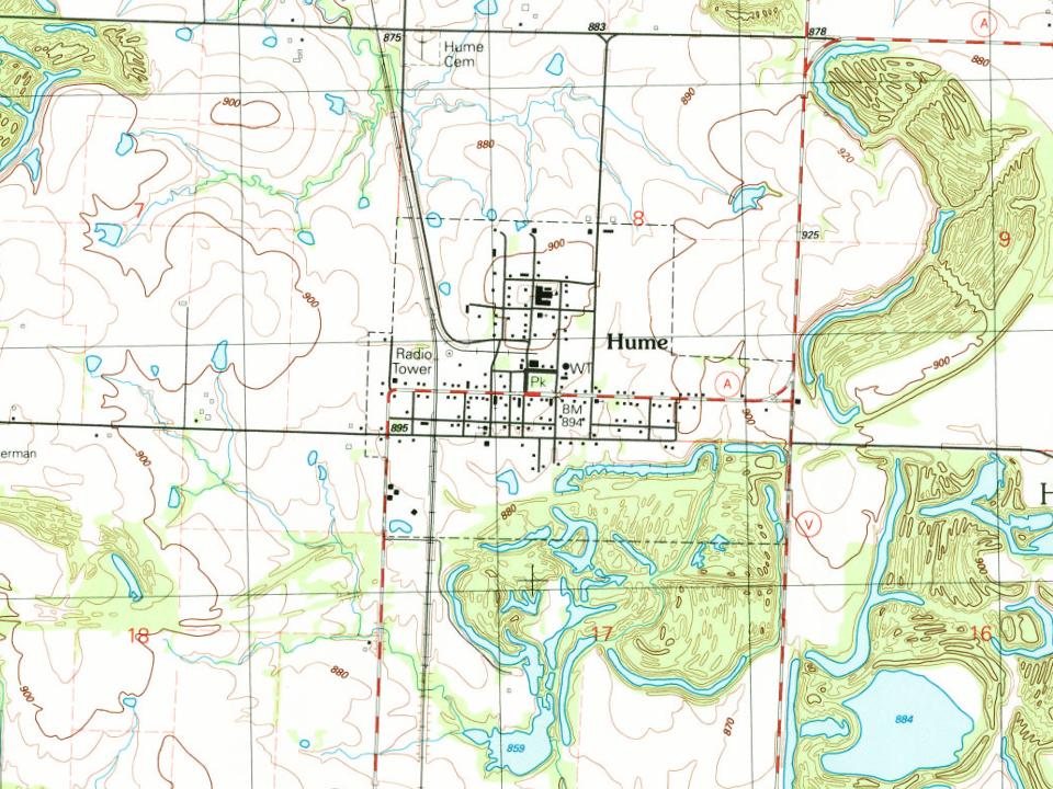
Hume on the map, 1940 to 1991

Every edition of the U.S. Geological Survey’s map of Hume. Tap a year, or press play to watch the town change.

Hume on the 1940 USGS mapHume on the 1991 USGS map1940Hume sheet · 1:24,000

U.S. Geological Survey historical topographic maps (public domain), via Esri’s collection of the scans. The red ring marks the center of Hume.

Every building

Hume, building by building, 1916

Fire insurance maps drew every building, what it was made of and what it was used for, so insurers could price the risk of fire. Pick a sheet.

Hume fire insurance map, 1916, sheet 11916Sheet 1 of 1
Sheets
BrickWoodStone

Sanborn Map Company, via the Library of Congress. Editions published in 1930 or earlier, which are in the public domain.

Famous people

2 famous people were born in Hume

Writers, athletes, leaders and more, ranked by how widely they’re known.

See all →

Questions about Hume’s history

What year was Hume founded?

The Hume post office opened in 1860, the earliest record of the town by name (U.S. post office records). Wikidata gives 1880.

Memory lane

What the archives can’t tell you, neighbors can.

Town Square →
Start a conversation
Sources

Where this page comes from

Founding dates: Wikidata, Wikipedia, the U.S. post office records of Blevins & Helbock (CC0) and the Census. Homes by year built: Census ACS 2020–24. National Register of Historic Places: National Park Service (list of May 22, 2026). Old photos, postcards and papers: Wikimedia Commons, the Library of Congress and other public archives, credited on each item’s page. Maps: U.S. Geological Survey historical topographic maps (via Esri) and Sanborn fire-insurance maps (Library of Congress). History text and census tables: Wikipedia (CC BY-SA 4.0). Places that used to be: USGS Geographic Names Information System (2021). How TownRatings grades history →

From Wikipedia, Wikidata and Wikipedia for famous people, U.S. Geological Survey historical maps, U.S. Census counts (via Wikipedia), the US Post Offices dataset (Blevins & Helbock), the USGS Geographic Names Information System, Sanborn fire insurance maps (Library of Congress) and old county and town histories (Internet Archive). Archive images are copied here with their credits and licenses, shown on each photo’s page. Refreshed monthly.