The story
Read it all →How Foster came to be
From Wikipedia’s history of Foster.
A post office called Foster has been in operation since 1883. The village was named after Charles Foster, governor of Ohio.
Text from Wikipedia, licensed CC BY-SA 4.0.
Each edition grades its towns against each other only.
Below: 1 old photo or paper, maps from 1938 on, and the census since 1890.
The Foster post office opened in 1883, the earliest record of the town by name.
Read from the archive, the National Register and the record. The page puts what stands out first.
The first neighbors to add old photos shape how Foster’s history is told.
From Wikipedia’s history of Foster.
A post office called Foster has been in operation since 1883. The village was named after Charles Foster, governor of Ohio.
Text from Wikipedia, licensed CC BY-SA 4.0.
Passages that mention Foster, cut from the printed page as they were published.

and in 1867, came out West and made a settlement in Jackson county, Missouri, where he resided until 1880. In that year he located in Bates county, living on a farm near Worland, until his removal to a farm near Foster. When the town of Foster was started, he engaged in the livery and transfer business and also carried the mail for several years. I^ater, he engaged in the grocery business after disposing of his livery business. When the town, or business section, of Foster was destroyed by fire, his place of business was burned out and he then went to Okla-
Text read by machine from the scan; it may contain errors.
The subsequent life of La Bette City was short and like Foster in Bates county, practically only a postofiice and railroad depot were left and the townsite reverted to farm lands. Being let out. Mr. Stevens turned up with his St. Louis & New Mexico enterprise and it was much talked of at Butler and several meetings were held in its interest but nothing of a definite understanding resulted and after the spring of 1871 the enthusiasm in regard to this scheme died out and the north and south road enterprises gained friends and while there was some
Text read by machine from the scan; it may contain errors.
FOSTER. Foster was boru on a boom. First called Walnut, it was re-christened in honor of Gov. Foster, of Ohio, who was at the head of the company which laid out the town in 1884. Lots were sold rapidly and at a high price. Many buildings were erected, and Foster was to rival, if not surpass, the mining town of Rich Hill. But the company failed to carry through its original plans, and her coal tieids have not been extensively developed. After the collapse of the
Text read by machine from the scan; it may contain errors.Scans and text from the Internet Archive. Books published in 1930 or earlier, which are in the public domain.
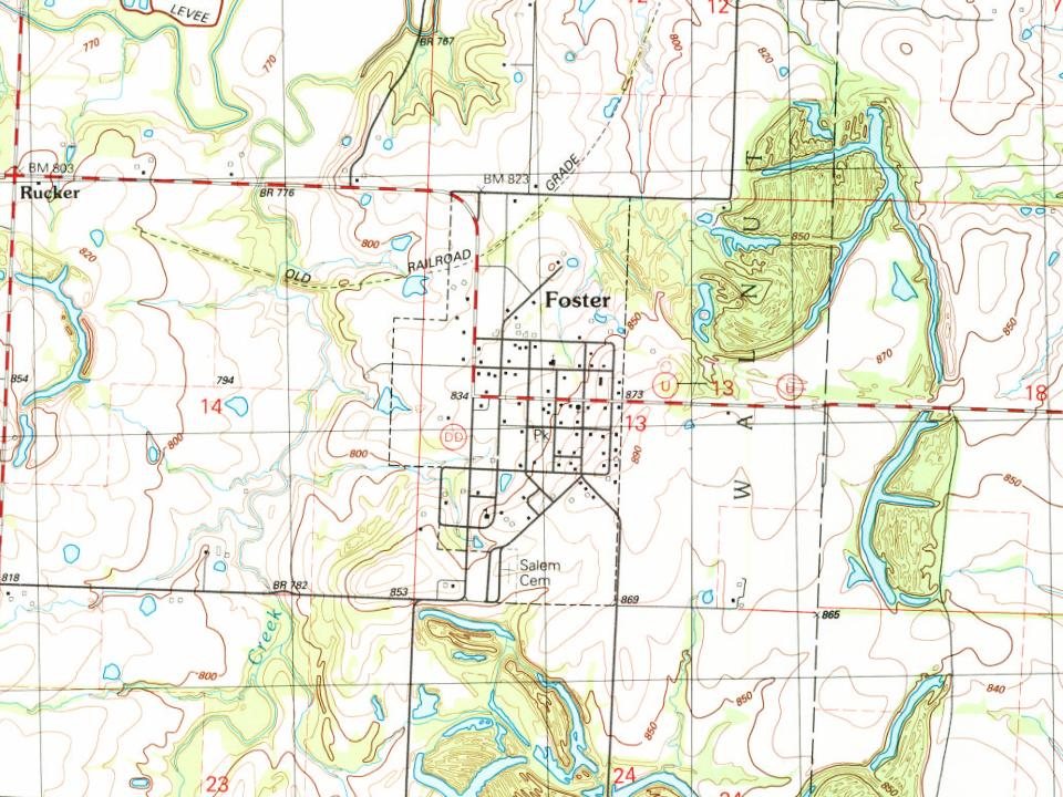
Every edition of the U.S. Geological Survey’s map of Foster. Tap a year, or press play to watch the town change.

U.S. Geological Survey historical topographic maps (public domain), via Esri’s collection of the scans. The red ring marks the center of Foster.
Between 76 and 513 people in every census since 1890.
14 censuses, 1890–2020.
U.S. Census Bureau decennial counts, from the census table on Foster’s Wikipedia page.
Foster’s post office has been open since 1883.
US Post Offices dataset (Blevins & Helbock, CC0). Places and cemeteries from the USGS Geographic Names Information System (2021).
The Foster post office opened in 1883, the earliest record of the town by name (U.S. post office records).
What the archives can’t tell you, neighbors can.
Founding dates: Wikidata, Wikipedia, the U.S. post office records of Blevins & Helbock (CC0) and the Census. Homes by year built: Census ACS 2020–24. National Register of Historic Places: National Park Service (list of May 22, 2026). Old photos, postcards and papers: Wikimedia Commons, the Library of Congress and other public archives, credited on each item’s page. Maps: U.S. Geological Survey historical topographic maps (via Esri) and Sanborn fire-insurance maps (Library of Congress). History text and census tables: Wikipedia (CC BY-SA 4.0). Places that used to be: USGS Geographic Names Information System (2021). How TownRatings grades history →
From Wikimedia Commons (1), Wikipedia, U.S. Geological Survey historical maps, U.S. Census counts (via Wikipedia), the US Post Offices dataset (Blevins & Helbock), the USGS Geographic Names Information System and old county and town histories (Internet Archive). Archive images are copied here with their credits and licenses, shown on each photo’s page. Refreshed monthly.
 Date?