Carthage dates to 1842, and 16% of its homes were built before 1940
More historic than 91% of U.S. towns · #11 of 247 in Missouri. What drives it
7 places in town are on the National Register, among them four historic districts with 586 buildings between them. Below: 2 old photos and papers, maps from 1886 on, and the census since 1880.
Founding year: Wikidata. First post office: 1843.The full story ↓
History grade
What drives Carthage’s History grade
On its age, its old homes and the National Register, Carthage is more historic than 91% of U.S. towns, #11 of 247 in Missouri. All 3 inputs are above most U.S. towns; its National Register listings ranks highest and its share of homes from before 1940 lowest.
A
HistoryA character grade: shown, never part of Carthage’s overall grade.
Missouri towns list about as much on the Register as the country (a typical Missouri town has 2.4 per 10,000 residents, the U.S. 2.4), so Carthage’s 379 sits above most of its state (98% of Missouri towns have fewer) while its 591 historic buildings outnumber those of 98% of U.S. towns.
How sure. Graded on any two of the three inputs instead, the letter would range from B+ to A+. The pre-1940 share is a Census survey estimate (±3.7 points). Two sources give 1842.
Founding year: Wikidata (other dates in Quick answers). Homes: Census ACS 2020–24. National Register: National Park Service, May 2026 list; each listing counted once (boundary changes and added documentation belong to their listing), and a historic district counts its contributing buildings. How TownRatings grades history →
What stands out about Carthage’s past
Read from the archive, the National Register and the record. The page puts what stands out first.
Jasper County was formed in 1841. Carthage was chosen as the county seat, the area cleared and the town platted in 1842. The city was named after the ancient city-state of Carthage, one of the Roman Republic's main rivals (in what is now Tunisia). By the time of the American Civil War, there were over 500 residents, a brick and stone courthouse, and several businesses.
Passages that mention Carthage, cut from the printed page as they were published.
A history of Jasper County, Missouri, and its people1912Read the page →
Read the text
On March 12, 1868, a petition was presented to the county court by M. C. McGregor on behalf of two hundred and six tax-paying citizens of Carthage When Incorporated as a City Carthage praying that body to incorporate that place as a town, and accordingly a decree was granted erecting the town of Carthage into a municipality, the original limits of the town being as follows: Commencing at the northwest comer of Parson & Case's addition to said town of Carthage, running thence north 800 feet; thence east 6,110 feet;
Text read by machine from the scan; it may contain errors.
The history of Jasper county, Missouri1883 · page 176Read the page →
Read the text
int ) Carthage, into a freight and passenger depot, to be erected and maintained not more than one-half mile from where the court-house in Carthage no'v stands, from some other railroad on which the cars run regularly; at which time there shall be delivered to such company the said sum of $100,000 of said bonds, which shall be received by said company in full payment for said $100,000 of the stock of said company; and provided further, that if said railroad shall not be completed to the town of Carthage from such other railroad as herein before provided, within two years from
Text read by machine from the scan; it may contain errors.
The history of Jasper county, Missouri1883 · page 253Read the page →
Read the text
under date of March 12, 1868, in the proceedings of the county court, we find the following reference: "On this day comes M. G. McGregor and presents to the court a petition signed by 206 taxable inhabitants of the town of Carthage that a police be established for the local government of the same, and for the preservation and regulation of any commons appertaining to said town within the following metes and bounds; viz., Commencino' at the northwest corner of Parson & Case's addition to said town of Carthage, running thence north 800 feet; thence east 6,110 feet; thence
Text read by machine from the scan; it may contain errors.
A history of Jasper County, Missouri, and its people1912Read the page →
Read the text
The Jasper County Electric Railway Company, composed mostly of Carthage capital, was organized in 1892 for the purpose of building an electric railway from Carthage to Carterville and Webb City. After securing franchises in Carthage and Carterville, during which time many obstacles were overcome, work on the line was commenced in 1894 and the road completed in July, 1895. The road, which is now a part of the South West Missouri Railway Company System, at first entered Carterville from the south, running through the northern portion of Johns-
Text read by machine from the scan; it may contain errors.
Scans and text from the Internet Archive. Books published in 1930 or earlier, which are in the public domain.
Timeline
Carthage, 1842 to 1969
Woven from the archive, old maps, post office records, the National Register and the people born here.
Nothing in the archives for these yearsWeddings on Main Street, storms, parades, school pictures, the old store. If it’s in your family album, it belongs here.
Eugene Field SchoolschoolHawthorne SchoolschoolMyers Park Memorial Municipal AirportairportOur Lady of the Ozarks CollegeschoolPrairie View Schoolschool
3cemeteries and burying grounds inside Carthage
Cedar HillOak HillPark
US Post Offices dataset (Blevins & Helbock, CC0). Places and cemeteries from the USGS Geographic Names Information System (2021).
Questions about Carthage’s history
What year was Carthage founded?
In 1842, according to Wikidata. Carthage’s post office opened in 1843, and the census of 1880 counted 4,167 people here.
How does Carthage rank for history?
Carthage is more historic than 91% of U.S. towns, #11 of 247 in Missouri. The History grade combines the town’s founding era, the share of homes built before 1940 and its National Register listings. It’s a character grade, so it isn’t part of the overall grade. How it works.
What is on the National Register in Carthage?
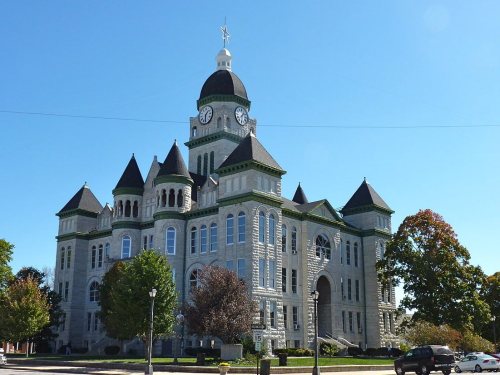
7 listings: 3 buildings, among them the Jasper County Courthouse (listed 1973, the first), and 4 historic districts with 586 contributing buildings. 591 historic buildings in all.
How old are the homes in Carthage?
16% of Carthage’s homes were built before 1940 (Census estimate, ±3.7 points), against a typical 8.4% for a Missouri town; the median home was built in 1973.
Founding dates: Wikidata, Wikipedia, the U.S. post office records of Blevins & Helbock (CC0) and the Census. Homes by year built: Census ACS 2020–24. National Register of Historic Places: National Park Service (list of May 22, 2026). Old photos, postcards and papers: Wikimedia Commons, the Library of Congress and other public archives, credited on each item’s page. Maps: U.S. Geological Survey historical topographic maps (via Esri) and Sanborn fire-insurance maps (Library of Congress). History text and census tables: Wikipedia (CC BY-SA 4.0). Places that used to be: USGS Geographic Names Information System (2021).
From Wikimedia Commons (5), Wikidata (1), the National Register of Historic Places (7), Wikipedia, Wikidata and Wikipedia for famous people, U.S. Geological Survey historical maps, U.S. Census counts (via Wikipedia), the US Post Offices dataset (Blevins & Helbock), the USGS Geographic Names Information System and old county and town histories (Internet Archive). Archive images are copied here with their credits and licenses, shown on each photo’s page. Refreshed monthly.




 2008
 2005
 2000
