Bunceton was laid out and platted in 1868. The city was named for Harvey Bunce, an early county resident. A post office has been in operation at Bunceton since 1868. In 1980, Bunceton elected the United States' first openly gay mayor, Gerald Ulrich.
Passages that mention Bunceton, cut from the printed page as they were published.
History of Cooper County, Missouri1919 · page 789Read the page →
Read the text
M. K. Gentry was educated in the public schools of Kentucky, and D. S. Cully's private academy, which was three miles northwest of the present town of Bunceton. After Bunceton was laid out this school was moved there and occupied the site of the present Bunceton High School. Mr. Gentry was reared to manhood on the home farm in Kelly township, and in 1880 removed to Boonville, and for a time was engaged in the grain business. In 1884 he was elected county treasurer on the Republican ticket by a majority of 48 votes. He was the first republican ever elected
Text read by machine from the scan; it may contain errors.
History of Cooper County, Missouri1919 · page 938Read the page →
Read the text
In 1919, Mr. Brickey purchased the "Elkins & Elkins Garage" at Bunceton, Mo., as a Ford Sales and Service Station in that section of the county and is known as the "Bunceton Auto Company." The building in which he conducts this business is about 60x90 feet, and the business there is a thriving one. In the spring of 1918 he sold a one-half interest in the Bunceton Auto Company to J. H. Schlotzhauer, who from that date became the active manager there.
Text read by machine from the scan; it may contain errors.
Scans and text from the Internet Archive. Books published in 1930 or earlier, which are in the public domain.
Timeline
Bunceton, 1868 to 1953
Woven from the archive, old maps, post office records, the National Register and the people born here.
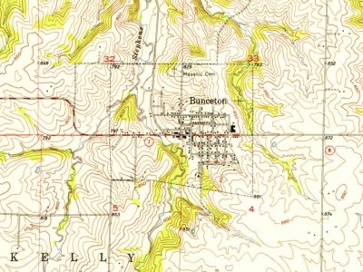
Founding dates: Wikidata, Wikipedia, the U.S. post office records of Blevins & Helbock (CC0) and the Census. Homes by year built: Census ACS 2020–24. National Register of Historic Places: National Park Service (list of May 22, 2026). Old photos, postcards and papers: Wikimedia Commons, the Library of Congress and other public archives, credited on each item’s page. Maps: U.S. Geological Survey historical topographic maps (via Esri) and Sanborn fire-insurance maps (Library of Congress). History text and census tables: Wikipedia (CC BY-SA 4.0). Places that used to be: USGS Geographic Names Information System (2021). How TownRatings grades history →
From Wikimedia Commons (2), the Library of Congress (6), Wikipedia, Wikidata and Wikipedia for famous people, U.S. Geological Survey historical maps, U.S. Census counts (via Wikipedia), the US Post Offices dataset (Blevins & Helbock), the USGS Geographic Names Information System, Sanborn fire insurance maps (Library of Congress) and old county and town histories (Internet Archive). Archive images are copied here with their credits and licenses, shown on each photo’s page. Refreshed monthly.


 Date?
 Date?
 Date?
 Date?
 Date?
 Date?
 2015
 2004


