Benton dates to 1796, and 1 of its places is on the National Register
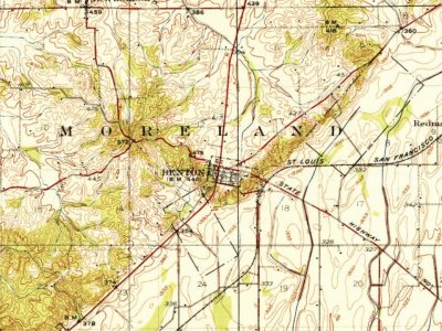
Most of Benton was built recently: 9% of its homes predate 1940 and the median home dates from 1979. Its Register listing is the Scott County Courthouse. Below: maps from 1934 on and the census since 1880.
Benton was settled as early as 1796. The town site was platted in 1822. The community was named after Thomas Hart Benton. A post office has been in operation at Benton since 1823.
Passages that mention Benton, cut from the printed page as they were published.
A sketch of the history of Benton County, Missouri1876 · page 30Read the page →
Read the text
Benton County, south of the river, I think was attached to Washington County till January 10th, 1831, when, I think, it was attached to Crawford County, till January 2d, 1833, when it became a part of Greene, I think, though the only evidence of this I can find is, that the citizens of Benton, by the act organizing Benton, were required to pay taxes then due to the Counties of Pettis and Greene.
Text read by machine from the scan; it may contain errors.
A sketch of the history of Benton County, Missouri1876 · page 19Read the page →
Read the text
It seems to have been during this fever of land speculation that the first great tide of immigration settled in Missouri. The particulars of the settlement of Benton County during this time, from 1833 to 1836, when the first census was taken, I have been unable to obtain, and if I had them, their narration would be too lengthy for this sketch. I can only make some general allusions to the settlement of localities not before mentioned. Before any white settlers came on to this creek, three free negroes settled
Text read by machine from the scan; it may contain errors.
Scans and text from the Internet Archive. Books published in 1930 or earlier, which are in the public domain.
Founding dates: Wikidata, Wikipedia, the U.S. post office records of Blevins & Helbock (CC0) and the Census. Homes by year built: Census ACS 2020–24. National Register of Historic Places: National Park Service (list of May 22, 2026). Old photos, postcards and papers: Wikimedia Commons, the Library of Congress and other public archives, credited on each item’s page. Maps: U.S. Geological Survey historical topographic maps (via Esri) and Sanborn fire-insurance maps (Library of Congress). History text and census tables: Wikipedia (CC BY-SA 4.0). Places that used to be: USGS Geographic Names Information System (2021). How TownRatings grades history →
From Wikimedia Commons (1), the National Register of Historic Places (1), Wikipedia, Wikidata and Wikipedia for famous people, U.S. Geological Survey historical maps, U.S. Census counts (via Wikipedia), the US Post Offices dataset (Blevins & Helbock), the USGS Geographic Names Information System and old county and town histories (Internet Archive). Archive images are copied here with their credits and licenses, shown on each photo’s page. Refreshed monthly.



 2004


