Wabasso was platted in 1889. Wabasso is a name derived from ‘waabooz’ (IPA: [waːbʊːs]), the Ojibwe word for “snowshoe hare” or more generally "rabbit". The city was incorporated in 1900. A post office called Wabasso has been in operation since 1900.
Passages that mention Wabasso, cut from the printed page as they were published.
The history of Redwood County, Minnesota1916 · page 585Read the page →
Read the text
In 1899 the railroad had been built from Sanborn to Vesta, and in that winter or the next spring, the postoffices of Wabasso, Seaforth and Wanda were established, while the Vesta postoffice was moved from section 22, Vesta township, to the new village of that name.
Text read by machine from the scan; it may contain errors.
The history of Redwood County, Minnesota1916 · page 549Read the page →
Read the text
Wabasso was incorporated in 1900. On March 17, 1900, the census of that date having shown a population of 184, a petition was drawn up, asking the commissioners to incorporate parts of sections 23 and 26, township 112, range 37. The petition was granted April 23, and an election called for April 28, 1900. The election was duly held in charge of G. H. Probett, A. E. Wertzler and Otto Schmidt, and of the forty-eight votes cast, all were in favor of the incorporation.
Text read by machine from the scan; it may contain errors.
Scans and text from the Internet Archive. Books published in 1930 or earlier, which are in the public domain.
By decade
Wabasso, decade by decade
One decade in the archive so far: the 1910s. Scroll each row; tap a photo for its story.
Nothing in the archives for these yearsWeddings on Main Street, storms, parades, school pictures, the old store. If it’s in your family album, it belongs here.
Founding dates: Wikidata, Wikipedia, the U.S. post office records of Blevins & Helbock (CC0) and the Census. Homes by year built: Census ACS 2020–24. National Register of Historic Places: National Park Service (list of May 22, 2026). Old photos, postcards and papers: Wikimedia Commons, the Library of Congress and other public archives, credited on each item’s page. Maps: U.S. Geological Survey historical topographic maps (via Esri) and Sanborn fire-insurance maps (Library of Congress). History text and census tables: Wikipedia (CC BY-SA 4.0). Places that used to be: USGS Geographic Names Information System (2021). How TownRatings grades history →
From Wikimedia Commons (4), the Library of Congress (2), Wikipedia, the US Post Offices dataset (Blevins & Helbock), the USGS Geographic Names Information System and old county and town histories (Internet Archive). Archive images are copied here with their credits and licenses, shown on each photo’s page. Refreshed monthly.


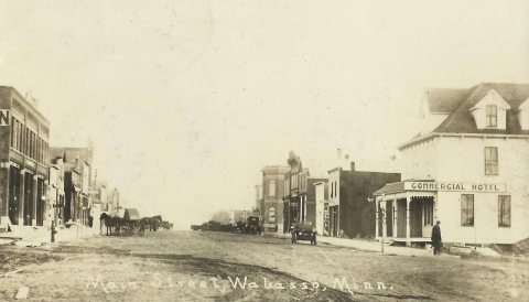 1914
 2020
 2020
 2020
 2020
 2005