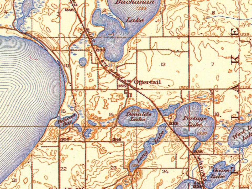
Most of Ottertail was built recently: 9% of its homes predate 1940 and the median home dates from 1996. Below: 1 old photo or paper, maps from 1912 on, and the census since 1910.
The Ottertail post office opened in 1894, the earliest record of the town by name. Another post office, Otter Tail City (1856), opened inside today’s city and later closed.
First census: 176 in 19102020 census: 629132 years
Founding year: the first Ottertail post office (Blevins & Helbock, CC0).The full story ↓
What stands out about Ottertail’s past
Read from the archive, the National Register and the record. The page puts what stands out first.
Passages that mention Ottertail, cut from the printed page as they were published.
History of Otter Tail County, Minnesota1916 · page 697Read the page →
Read the text
Ohio, on July 3, 1S41, and as a young man followed the occupation of a farmer in the state where he was horn. He came to Minnesota in [866, where for a short time he stopped in St. ('loud. In 1868 he came to Otter Tail county, and settled in Ottertail, when the place just mentioned was a village, whose inhabitants lived in tents. In Ottertail village, Randolph Frazee built the first sawand grist-mill ever known in the place. After a few years the railroad, which was being put through that section of the county, failed to take account of Ottertail village as a possible station, and
Text read by machine from the scan; it may contain errors.
and une-half years and then at Dressier Junction, Wisconsin, for two months. After that he was the agent at Kilbernie. North Dakota, for two years and after that, at Kuhn, North Dakota, for six months. He was operator at the front during the construction of the railroad from Ottertail, Minnesota, to the Canadian boundary and. on July 8, 1904, came to Henning, tins county. With the exception of three months spent at Colorado Springs, lie has been stationed at Henning continuously ever since. While at Colorado Springs he was both the operator and ticket agent.
Text read by machine from the scan; it may contain errors.
Scans and text from the Internet Archive. Books published in 1930 or earlier, which are in the public domain.
Timeline
Ottertail, 1856 to 2020
Woven from the archive, old maps, post office records, the National Register and the people born here.
Founding dates: Wikidata, Wikipedia, the U.S. post office records of Blevins & Helbock (CC0) and the Census. Homes by year built: Census ACS 2020–24. National Register of Historic Places: National Park Service (list of May 22, 2026). Old photos, postcards and papers: Wikimedia Commons, the Library of Congress and other public archives, credited on each item’s page. Maps: U.S. Geological Survey historical topographic maps (via Esri) and Sanborn fire-insurance maps (Library of Congress). History text and census tables: Wikipedia (CC BY-SA 4.0). Places that used to be: USGS Geographic Names Information System (2021). How TownRatings grades history →
From Wikimedia Commons (4), Wikipedia, U.S. Geological Survey historical maps, U.S. Census counts (via Wikipedia), the US Post Offices dataset (Blevins & Helbock), the USGS Geographic Names Information System and old county and town histories (Internet Archive). Archive images are copied here with their credits and licenses, shown on each photo’s page. Refreshed monthly.


 Date?
 2017
 2007
 2005