Mount Clemens dates to 1799, and 32% of its homes were built before 1940
More historic than 88% of U.S. towns · #78 of 701 in Michigan. What drives it
Its Register listings are the Grand Trunk Western Railroad, Mount Clemens Station and the Mount Clemens Public Library. Below: 6 old photos and papers, maps from 1929 on, and the census since 1850.
Founding year: Wikidata. First post office: 1821.The full story ↓
History grade
What drives Mount Clemens’ History grade
On its age, its old homes and the National Register, Mount Clemens is more historic than 88% of U.S. towns, #78 of 701 in Michigan. All 3 inputs are above most U.S. towns; its share of homes from before 1940 ranks highest and its National Register listings lowest.
A
HistoryA character grade: shown, never part of Mount Clemens’ overall grade.
Few Michigan towns list much on the Register (a typical Michigan town has 0.0 per 10,000 residents, the U.S. 2.4), so Mount Clemens’ 1.3 sits above most of its state (67% of Michigan towns have fewer) while its 2 listings outnumber those of 60% of U.S. towns.
How sure. Graded on any two of the three inputs instead, the letter would range from A− to A. The pre-1940 share is a Census survey estimate (±3.8 points). Two sources give 1799.
Founding year: Wikidata (other dates in Quick answers). Homes: Census ACS 2020–24. National Register: National Park Service, May 2026 list; each listing counted once (boundary changes and added documentation belong to their listing), and a historic district counts its contributing buildings. How TownRatings grades history →
What stands out about Mount Clemens’ past
Read from the archive, the National Register and the record. The page puts what stands out first.
Mount Clemens was first surveyed in 1795 after the Revolutionary War by Christian Clemens, who settled there four years later. Clemens was the son of a Pennsylvanian Mennonite farming family Clemens and his friend Oliver Wiswell purchased a distillery built in 1797 by John Brooks, which attracted workers and customers, helping to settle the area. Brooks and Clemens platted the land, and the town was named after Clemens in 1818. It received a post office in 1821, with John Stockton as the first postmaster. Christian Clemens is buried at Clemens Park, located just north of downtown.
Indian mounds were in the vicinity, more specifically just north of the Clinton River near the present location of Selfridge Air National Guard Base.
Passages that mention Mount Clemens, cut from the printed page as they were published.
History of Macomb County, Michigan, containing ... biographical sketches, portraits of prominent men and early settlers1882Read the page →
Read the text
The act of the Legislature, approved April -t. 1851. ordained that the territory within the following boundaries should be known as the village of Mount Clemens, viz.: Commencing at a point in the center of the Clinton, on the line between Harrison and Clinton; thence following the center of the river up stream to a i)oint where the westerly line of P. C. 139. originally jiatented to Richard Patterson, strikes the center of the river; thence northwardly to a point from which a line running due east will form the south line of the farm owned by the heirs of Mitchell; thence easterly to the line between Clinton and Harrison, and along that line to the place of beginning. The subject of amending the act
Text read by machine from the scan; it may contain errors.
History of Macomb County, Michigan, containing ... biographical sketches, portraits of prominent men and early settlers1882Read the page →
Read the text
Hoxie must have settled here sometime between 1818 and 1822. Two young men visited him here in 1823. They were Samuel Chamberliu, of Lima, N. Y. , and Edward Brewster, of Riga, N. Y. They came West by waj' of the lakes, landed at Detroit, came to Mount Clemens, procured ponies and came on to Hoxie's, retiirning to Detroit through the present town of Troy. When Farmer issued his sectional map of Michigan, in 1828, he marked the present site of Romeo as Hoxie's Settlement, but the postoffice.'established in 1826, bore the name of Indian Village. It is understood distinctly that Asahel Bailey was the pioneer.
Text read by machine from the scan; it may contain errors.
History of Macomb County, Michigan, containing an account of its settlement, growth, development and resources...churches, schools and societies1882 · page 448Read the page →
Read the text
according to the terms of said subscription and at the time therein specified, by wealthy citizens of Romeo, representing a capital of, at least, $590,000, 3'our petitioners would therefore in consideration of the premises, respectfully petition and ask your honorable body to submit the question of removal of the county seat of Macomb County from the village of Mount Clemens to the village of Romeo at the next annual township meeting to be held in the several townships of the county to a vote of the qualified electors of said county and your petitioners will ever pray, etc.
Text read by machine from the scan; it may contain errors.
History of Macomb County, Michigan, containing an account of its settlement, growth, development and resources...churches, schools and societies1882 · page 265Read the page →
Read the text
a Keg of Crold, near where now is the railroad bridge, in olden as well as modern times. It is related, that about the years 1810-13, the paymaster of the British garrisons along the lakes, left Detroit, en route to the Indian villages, then in the vicinity of Mount Clemens, to distribute the price of American scalps among the tribes. The old trail was by the river ford in the immediate vicinity of the present railroad bridge and the Morass House. The river was swollen at the time, so that it was necessary to requisition a canoe for the transfer of the officer and his golden charge to the left bank of tlie river. This resulted in the capsizing of the
Text read by machine from the scan; it may contain errors.
Scans and text from the Internet Archive. Books published in 1930 or earlier, which are in the public domain.
By decade
Mount Clemens, decade by decade
One decade in the archive so far: the 1880s. Scroll each row; tap a photo for its story.
Nothing in the archives for these yearsWeddings on Main Street, storms, parades, school pictures, the old store. If it’s in your family album, it belongs here.
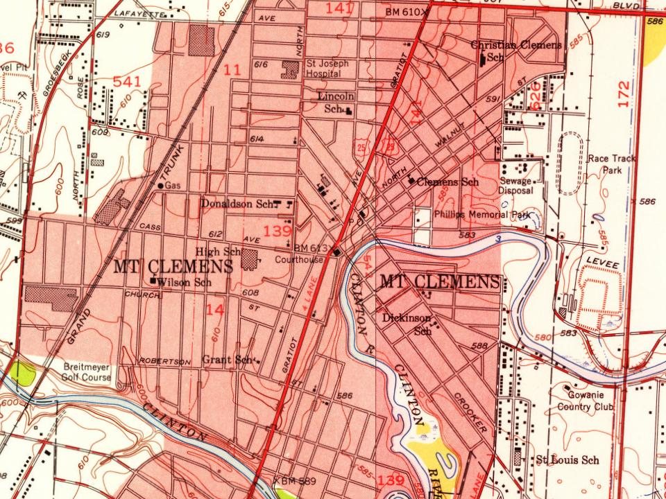
Every edition of the U.S. Geological Survey’s map of Mount Clemens. Tap a year, or press play to watch the town change.
1929Mt Clemens sheet · 1:62,500
U.S. Geological Survey historical topographic maps (public domain), via Esri’s collection of the scans. The red ring marks the center of Mount Clemens.
Then & now
Stand where they stood
No then-and-now pairs yet. Take a photo from the same spot as an old one and they appear here side by side.
Retake this viewEgnew-Avery Hotel, 1880
Find the spot, match the angle, and add your photo. It becomes the first then-and-now pair on Mount Clemens’ page.
In 1799, according to Wikidata. Mount Clemens’ post office opened in 1821, and the census of 1850 counted 1,302 people here.
How does Mount Clemens rank for history?
Mount Clemens is more historic than 88% of U.S. towns, #78 of 701 in Michigan. The History grade combines the town’s founding era, the share of homes built before 1940 and its National Register listings. It’s a character grade, so it isn’t part of the overall grade. How it works.
What is on the National Register in Mount Clemens?
Two places: the Grand Trunk Western Railroad, Mount Clemens Station (listed 1981) and the Mount Clemens Public Library (2021).
How old are the homes in Mount Clemens?
32% of Mount Clemens’ homes were built before 1940 (Census estimate, ±3.8 points), against a typical 12% for a Michigan town; the median home was built in 1955.
Founding dates: Wikidata, Wikipedia, the U.S. post office records of Blevins & Helbock (CC0) and the Census. Homes by year built: Census ACS 2020–24. National Register of Historic Places: National Park Service (list of May 22, 2026). Old photos, postcards and papers: Wikimedia Commons, the Library of Congress and other public archives, credited on each item’s page. Maps: U.S. Geological Survey historical topographic maps (via Esri) and Sanborn fire-insurance maps (Library of Congress). History text and census tables: Wikipedia (CC BY-SA 4.0). Places that used to be: USGS Geographic Names Information System (2021).
From the Library of Congress (6), the National Register of Historic Places (2), Wikipedia, Wikidata and Wikipedia for famous people, U.S. Geological Survey historical maps, U.S. Census counts (via Wikipedia), the US Post Offices dataset (Blevins & Helbock), the USGS Geographic Names Information System and old county and town histories (Internet Archive). Archive images are copied here with their credits and licenses, shown on each photo’s page. Refreshed monthly.




 1880
 1880
 1880
 1880
 1880