Mason dates to 1836, and 16% of its homes were built before 1940
More historic than 90% of U.S. towns · #60 of 701 in Michigan. What drives it
9 places in town are on the National Register, among them three historic districts with 205 buildings between them. Below: 1 old photo or paper, maps from 1889 on, and the census since 1860.
Founding year: Wikidata. First post office: 1838.The full story ↓
History grade
What drives Mason’s History grade
On its age, its old homes and the National Register, Mason is more historic than 90% of U.S. towns, #60 of 701 in Michigan. All 3 inputs are above most U.S. towns; its National Register listings ranks highest and its share of homes from before 1940 lowest.
A
HistoryA character grade: shown, never part of Mason’s overall grade.
Few Michigan towns list much on the Register (a typical Michigan town has 0.0 per 10,000 residents, the U.S. 2.4), so Mason’s 256 sits above most of its state (97% of Michigan towns have fewer) while its 211 historic buildings outnumber those of 94% of U.S. towns.
How sure. Graded on any two of the three inputs instead, the letter would range from A− to A. The pre-1940 share is a Census survey estimate (±4.6 points). Two sources give 1836.
Founding year: Wikidata (other dates in Quick answers). Homes: Census ACS 2020–24. National Register: National Park Service, May 2026 list; each listing counted once (boundary changes and added documentation belong to their listing), and a historic district counts its contributing buildings. How TownRatings grades history →
What stands out about Mason’s past
Read from the archive, the National Register and the record. The page puts what stands out first.
Fire insurance maps drew every building, what it was made of and what it was used for, so insurers could price the risk of fire. Pick a year, then a sheet.
In 1836 Charles Noble knew that Michigan would be seeking a central location for a new capital when it became a state. He purchased an area of forest, cleared 20 acres (81,000 m2), and founded Mason Center. The "Center" was soon dropped. In 1847, however, the state chose Lansing Township 12 miles (19 km) northward to be its capital due to its potential for water power. Noble managed to make Mason the county seat instead. Ingham County's first downtown courthouse was built in 1843, and was replaced in 1858, and the economy thrived in the first decades based on sawmills, carriage and cart factories, copper shops, a steam flourmill and a buffalo robe manufacturer. In 1865, Mason was incorporated as a village; in 1875 the town became a city. In the 1800s, Mason was the center of Ingham County activity, even more than was Lansing, the state capital. In 1877, Lansing attempted to take the sta…
Passages that mention Mason, cut from the printed page as they were published.
History of Mason County, Michigan1882 · page 74Read the page →
Read the text
Terms to suit purchasers. At this place doubtless will be the first railroad station east of Ludington, and will be the best wooding station in Mason County. This, with the farming country around, will make it a thriving inland village. Thus is Amber built since, Chicago burned. May her population never grow less. ” In 1875, a schoolhouse was .built at the village, costing up¬ wards of $1,200. Among the early settlers in this township, who cleared good farms, were J. T. Reed, Jesse L. Towns, Mr. Van
Text read by machine from the scan; it may contain errors.
History of Mason County, Michigan1882 · page 71Read the page →
Read the text
The township of Summit was the first township erected by the board of supervisors of Mason County. At a meeting in December, 1859, it was voted that Town 17 north, of Range 18 west, except Sections 1, 2 and 8, and Town 17 north, of Range 17 west, except Sections 1, 2, 8, 4, 5 and 6, from the present township of Pere Marquette, be organized into a new township, to be called Summit. The first townsliip meeting was held the first Monday in April, 1860, at the house of William Quevillon. George
Text read by machine from the scan; it may contain errors.
Scans and text from the Internet Archive. Books published in 1930 or earlier, which are in the public domain.
Timeline
Mason, 1836 to 1986
Woven from the archive, old maps, post office records, the National Register and the people born here.
Nothing in the archives for these yearsWeddings on Main Street, storms, parades, school pictures, the old store. If it’s in your family album, it belongs here.
In 1836, according to Wikidata. Mason’s post office opened in 1838, and the census of 1860 counted 363 people here.
How does Mason rank for history?
Mason is more historic than 90% of U.S. towns, #60 of 701 in Michigan. The History grade combines the town’s founding era, the share of homes built before 1940 and its National Register listings. It’s a character grade, so it isn’t part of the overall grade. How it works.
What is on the National Register in Mason?
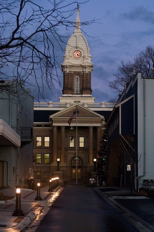
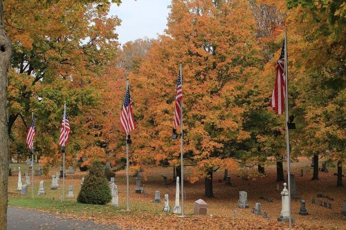
9 listings: 5 buildings, among them the Ingham County Courthouse (listed 1971, the first), 3 historic districts, the Maple Grove Cemetery, the Westside Neighborhood Historic District and the Courthouse Square Historic District, with 205 contributing buildings, and 1 structure. 211 historic buildings in all.
How old are the homes in Mason?
16% of Mason’s homes were built before 1940 (Census estimate, ±4.6 points), against a typical 12% for a Michigan town; the median home was built in 1978.
Founding dates: Wikidata, Wikipedia, the U.S. post office records of Blevins & Helbock (CC0) and the Census. Homes by year built: Census ACS 2020–24. National Register of Historic Places: National Park Service (list of May 22, 2026). Old photos, postcards and papers: Wikimedia Commons, the Library of Congress and other public archives, credited on each item’s page. Maps: U.S. Geological Survey historical topographic maps (via Esri) and Sanborn fire-insurance maps (Library of Congress). History text and census tables: Wikipedia (CC BY-SA 4.0). Places that used to be: USGS Geographic Names Information System (2021).
From Wikimedia Commons (12), the National Register of Historic Places (9), Wikipedia, Wikidata and Wikipedia for famous people, U.S. Geological Survey historical maps, U.S. Census counts (via Wikipedia), the US Post Offices dataset (Blevins & Helbock), the USGS Geographic Names Information System, Sanborn fire insurance maps (Library of Congress) and old county and town histories (Internet Archive). Archive images are copied here with their credits and licenses, shown on each photo’s page. Refreshed monthly.




 2009
 2009
 2009
 2009
 2009
 2009
 2009
 2009
 2009
 2009
 2009


