Guest, Sign inJoin

Post to Burt Township

We’ll email a one-tap link to publish your post. No password, and nothing is public until you click it.
Already a member? Sign in
Burt Township
Michigan›Alger County

Burt TownshipMI

A town of 401.

4 bordering townsMap →
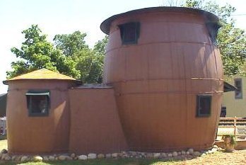
Pickle Barrel House · Photo: Doug Coldwell · CC BY-SA 3.0
Photo of Burt Township

Burt Township, MI · Pickle Barrel House · Photo: Doug Coldwell · CC BY-SA 3.0

Is Burt Township a good place to live?

65% of the land in Burt Township is conserved, above both Michigan’s towns (4.4%) and U.S. towns (4.3%). Pictured Rocks National Lakeshore (Federal Unit), at 23,197 acres with 28.1 miles of trail, is the biggest park or preserve. Burt Township has fewer than 1,000 residents, too few for fair grades; the figures below are still real.

Small town

401 people, and everyone knows the way

In a town this size, neighbors are the best guide. Ask them anything.

Nearby towns
McMillan TownshipSeney TownshipMunising TownshipHiawatha TownshipMcMillan TownshipSeney TownshipMunising TownshipHiawatha TownshipBurt Township
Au Sable Light Station
Au Sable Light Station · National Register of Historic Places
Burt Township’s story

Burt Township in pictures

Census counts: 457 in 1960, 522 in 2010. The archive holds 2 maps from 1966 on.

3 places on the National Register of Historic Places.

Explore the history →
Getting set up

Moving to Burt Township: who provides what

Who provides power, water and the rest in Burt Township, and how to reach them.

The full setup list →
PowerUpper Michigan Energy Resources17.5¢/kWh · EIA 2025HIFLD · EIA
WaterBurt Township water systemNo health-based violations in 5 years · EPAEPA
Internet2 providers98% of addresses get 100/20 MbpsFCC
Trash & dumpNot on file yetWe don’t have Burt Township’s trash rules yet
SchoolsBurt Township School DistrictWhich school depends on your addressNCES
Register to voteOnlineIn Michigan you can register online until 15 days before Election Day, in person up to and including Election Day, or by mail (postmarked 15 days before).vote.gov
Who runs elections hereBurt Township ClerkThe town itself; contacts on the Handbook page.FVAP, Nov 2025
ZIP codes49839, 49883, 4988449839 91% · 49883 5% · 49884 5%Census 2020

EPA SDWIS (Oct 9, 2026) · HIFLD + EIA-861 2025 · Census 2020 ZCTAs · NCES 2024–25 · registration: vote.gov, updated Sep 12, 2025.

The data

Ordered by what stands out in Burt Township.

Outdoors

In Burt Township, nearly a third of the land is conserved

Trails total 470 miles in 9 parks and preserves. Burt Township’s density of trails stands at 1.8 miles per square mile. Parks and preserves in the town: 9, covering 87,371 acres.

64.8%conserved
64.8%
conserved · 106,246 of 163,982 acres
470 mi
of trails · 1.8 per sq mi
Biggest places to walkTrailsAcres
1. Lake Superior State Forest - Shingleton Unit86.2 mi29,460
2. Pictured Rocks National Lakeshore (Inner Buffer Zone)55.9 mi17,901
3. Beaver Basin Wilderness39.5 mi10,096

Trails & parks © OpenStreetMap contributors · Conserved land: USGS PAD-US

Schools

The schools Burt Township’s kids attend

Its public schools are run by the Burt Township School District.

SchoolLevelStudentsLetter
Burt Township SchoolLargest public high schoolGrades K–12Grades K–1234C+

NCES · EDFacts

Natural hazards

Top of a very low hazard risk in Burt Township: inland flooding

One claim on flood insurance has been paid out in Burt Township since 2026. Expected storm and flood damage is lower than in 92% of U.S. communities. 54% of the town’s expected losses from natural hazards come from inland flooding, followed by lightning at 19%.

8risk score of 100
FEMA risk score
8Very low riskLowerHigher
Inland floodingLightningCold waves
1
paid flood claims since 2026

FEMA flood insurance claims · FEMA National Risk Index · OpenFEMA

Work & commute

With only 0.5 jobs per working resident, most people in Burt Township work out of town

The middle household income for Burt Township comes to $48,000, against $77,000 in Michigan’s towns and $80,000 across U.S. towns. Half the trips to work are shorter than 38 miles. The top destinations are Munising (42%), Munising Township (15%) and Au Train Township (7%).

4%work in town
Burt TownshipMichigan townsU.S. towns
Median household income$48,000$77,000$80,000
Working residents who work in town3.6%5.9%8%

Where working residents work

In Burt Township4%
Munising42%
Munising Township15%
Au Train Township7%
Marquette4%
38 mi
median commute distance
71
jobs based in Burt Township
A commuter town
jobs vs. working residents

Census LEHD 2021 · ACS

Climate

Burt Township stands out in Michigan and nationally, with a typical July afternoon cooler than most

Burt Township has cold winters and cool summers. July afternoons reach 76° and January nights drop to 9°.

76°summer high

Typical low → high °F

Winter11–26°
Spring27–48°
Summer51–74°
Fall36–52°
Oct 10
typical first frost
May 27
typical last frost
+1.4°
vs. the 20th-century average
76°
typical summer high

NOAA U.S. Climate Normals, 1991–2020

Health

Compared with most of Michigan and the rest of the country, fewer of Burt Township’s adults binge drink

Only 4 of the 702 Michigan towns we compare have a higher share of adults who have high blood pressure than Burt Township. For adults locally, the share who get no exercise outside work is 29%. The town does better than the Michigan average on 9 of 32 CDC measures and worse on 10.

Burt TownshipMichigan townsU.S. towns
High blood pressure (CDC PLACES)49%36%35%
Binge drink (CDC PLACES)12%17%16%
Diabetes (CDC PLACES)17%12%12%
Frequent physical distress (CDC PLACES)18%14%14%
32 measures vs. Michigan
9 better13 too close to call10 worse
What stands outBurt TownshipMI
Fewer adults facing housing insecurity8.5%11.9%
Fewer binge drinkers11.7%15.9%
More adults with heart disease12.2%7%
Munising Memorial Hospital
26.9 mi away · emergency room
2 of 3
care shortages: dental, mental health

CDC PLACES 2025 · modeled estimates for adults · CMS · HRSA

Keep exploring

Everything we know about Burt Township

16pages on Burt Township
After high school

Colleges nearby

None within 15 miles of Burt Township; the nearest are

Get outside

470 miles of trails in Burt Township

64.8% of the town is conserved land, across 9 parks and preserves.

Map of trails and conserved land in Burt TownshipConservedTrails
1
Lake Superior State Forest - Shingleton Unit86.2 mi of trails · 29,460 acres
Directions
2
Pictured Rocks National Lakeshore (Inner Buffer Zone)55.9 mi of trails · 17,901 acres
Directions
3
Beaver Basin Wilderness39.5 mi of trails · 10,096 acres
Directions
Trails © OpenStreetMap contributors · USGS PAD-US

Landmarks

3 places in Burt Township on the National Register of Historic Places.

All landmarks →

About Burt Township

Civil township in Michigan, United States

Burt Township is a civil township of Alger County in the U.S. state of Michigan. As of the 2020 census, its population was 411. The township contains the community of Grand Marais, which contains numerous historic structures, including the Pickle Barrel House and the Grand Marais Harbor of Refuge Inner and Outer Lights. The township is also the eastern gateway to the Pictured Rocks National Lakeshore and includes the Au Sable Light on the shores of Lake Superior.

From Wikipedia, licensed CC BY-SA 4.0 · facts via Wikidata (CC0)

Area
258 sq mi
Elevation
968 ft

Questions about Burt Township

Short answers, built from the data on this page.

Is Burt Township, MI a good place to live?

Burt Township has fewer than 1,000 residents, too few for fair grades; the figures below are still real.