On its age, its old homes and the National Register, Kingfield is more historic than 90% of U.S. towns. All 3 inputs are above most U.S. towns; its share of homes from before 1940 ranks highest and its National Register listings lowest.
A
HistoryA character grade: shown, never part of Kingfield’s overall grade.
Maine towns list more on the Register than most of the country (a typical Maine town has 15.9 per 10,000 residents, the U.S. 2.4), so Kingfield’s 48.8 sits above most of its state (75% of Maine towns have fewer) while its 4 listings outnumber those of 68% of U.S. towns.
NoteThe founding year comes from Wikipedia alone; no second source gives 1816.
How sure. Graded on any two of the three inputs instead, the letter would range from A− to A. The pre-1940 share is a Census survey estimate (±7.0 points).
Founding year: Wikipedia (other dates in Quick answers). Homes: Census ACS 2020–24. National Register: National Park Service, May 2026 list; each listing counted once (boundary changes and added documentation belong to their listing), and a historic district counts its contributing buildings. How TownRatings grades history →
What stands out about Kingfield’s past
Read from the archive, the National Register and the record. The page puts what stands out first.
The first recorded European visitors were John W. Dutton and Nathaniel Kimball in 1805. They returned the following year with their families and began a settlement. In 1807, William King (later to be Maine's first Governor) purchased the township as part of the Bigham Plantation. In 1816 Kingfield was incorporated as the 210th town in the Maine District of the Commonwealth of Massachusetts.
Passages that mention Kingfield, cut from the printed page as they were published.
A history of Farmington, Franklin County, Maine, from the earliest explorations to the present time, 1776-18851885 · page 195Read the page →
Read the text
In 1883 and 1884, considerable discussion was had and several meetings held regarding the building of a narrow gauge railroad to Kingfield. Two routes were proposed. One route was to leave the Center Village at Farmington, run through New Vineyard, West New Portland, and thence to Kingfield. The other route proposed was to leave the Sandy River Railroad at Strong Village, and thence pass through Freeman, Salem, and thence to Kingfield. Although
Text read by machine from the scan; it may contain errors.
A history of Farmington, Franklin County, Maine, from the earliest explorations to the present time, 1776-18851885 · page 361Read the page →
Read the text
assisted Joseph North in completing the survey of the town, ]5robably in 1784, and subsequently lotted a number of townships in tliis and adjoining counties, among which was the town of Kingfield. He was frequently employed by Mr. R. H. Gardiner in surveying his land in Gardiner. Mr. Adams was the last clerk of the Colburn Associates, and upon the incorporation of the town in 1794, was elected its moderator, and in 1795 its town clerk, a pos-
Text read by machine from the scan; it may contain errors.
A history of the town of Industry, Franklin County, Maine, from the earliest settlement in 1787 down to the present time1893 · page 511Read the page →
Read the text
He was the projector and builder of the suspension bridges at Strong and Kingfield, in Franklin County. At the last mentioned place the following incident is related in regard to the newly-completed bridge. The sway of the bridge when completed caused many people unacquainted with such structures to question its safety. To show his own confidence in the permanency and strength of the structure, Mr. Beede, in the presence of a large company of people, drove his horse across the bridge and back at full speed, and was heartily cheered on his return
Text read by machine from the scan; it may contain errors.
A history of the town of Industry, Franklin County, Maine, from the earliest settlement in 1787 down to the present time1893 · page 316Read the page →
Read the text
the town. The existing bitter partisan spirit had a tendency to magnify and distort the reports and great excitement prevailed, even in the little town of Industry. A detachment of the militia was sent to Kingfield to restore order and enforce the law. They found nothing to do, however, but to spend their time in hunting, fishing and feasting. Carefully considered, the bare facts show nothing to justify the application of the term "riot" to the Kingfield affair.
Text read by machine from the scan; it may contain errors.
Scans and text from the Internet Archive. Books published in 1930 or earlier, which are in the public domain.
By decade
Kingfield, decade by decade
2 decades in the archive, from the 1890s to the 1910s. Scroll each row; tap a photo for its story.
Nothing in the archives for these yearsWeddings on Main Street, storms, parades, school pictures, the old store. If it’s in your family album, it belongs here.
In 1816, according to Wikipedia’s history of the town. the census of 1820 counted 464 people here.
How does Kingfield rank for history?
Kingfield is more historic than 90% of U.S. towns. The History grade combines the town’s founding era, the share of homes built before 1940 and its National Register listings. It’s a character grade, so it isn’t part of the overall grade. How it works.
What is on the National Register in Kingfield?
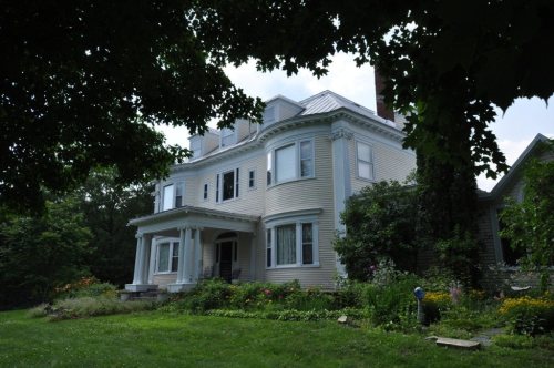
4 listings: 4 buildings, among them the Amos G. Winter House (listed 1976, the first).
How old are the homes in Kingfield?
29% of Kingfield’s homes were built before 1940 (Census estimate, ±7.0 points), against a typical 19% for a Maine town; the median home was built in 1973.
Founding dates: Wikidata, Wikipedia, the U.S. post office records of Blevins & Helbock (CC0) and the Census. Homes by year built: Census ACS 2020–24. National Register of Historic Places: National Park Service (list of May 22, 2026). Old photos, postcards and papers: Wikimedia Commons, the Library of Congress and other public archives, credited on each item’s page. Maps: U.S. Geological Survey historical topographic maps (via Esri) and Sanborn fire-insurance maps (Library of Congress). History text and census tables: Wikipedia (CC BY-SA 4.0). Places that used to be: USGS Geographic Names Information System (2021).
From Wikimedia Commons (8), Wikidata (2), the National Register of Historic Places (4), Wikipedia, Wikidata and Wikipedia for famous people, U.S. Geological Survey historical maps, U.S. Census counts (via Wikipedia), the USGS Geographic Names Information System, Sanborn fire insurance maps (Library of Congress) and old county and town histories (Internet Archive). Archive images are copied here with their credits and licenses, shown on each photo’s page. Refreshed monthly.




![assisted Joseph North in completing the survey of the town, ]5robably in 1784, and subsequently lotted a number of townships in tliis and adjoining counties, among which was the town of Kingfield. He was frequently employed by Mr. R. H. Gardiner in surveying his land in Gardiner. Mr. Adams was the …](https://images.townratings.com/story/23645/bk-959c16204694c8e8-l.jpg)


 Date?
 Date?
 Date?
 Date?
 2008
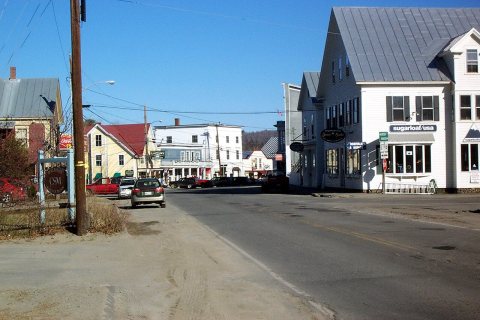 2003


