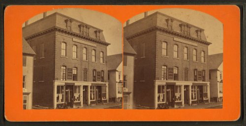
225 years in pictures
Census counts: 461 in 1820, 3,803 in 2020. The archive holds 22 old photos and papers going back to 1868 and 2 maps from 1933 on.
5 places on the National Register of Historic Places.
- 1801Dexter is settled
Each edition grades its towns against each other only.

Dexter grades C− overall, 113th of 142 graded towns in Maine, with clear strengths and some subjects that lag. Natural-hazard risk is low. On the other side, residents are less healthy than 90% of U.S. towns on CDC estimates. 23% of residents live below the poverty line in Dexter, above both Maine’s towns (9%) and U.S. towns (9.6%). Dexter has 5 places on the National Register of Historic Places, among them Dexter Grist Mill and Abbott Memorial Library. Among 143 Maine towns, just 6 have a lower share of adults with a bachelor’s degree than Dexter.
Where Dexter beats most towns, and one thing worth knowing.
Dexter Grist Mill| Widest gap | Dexter | ME |
|---|---|---|
| More adults with COPD | 11.6% | 8.4% |
Census counts: 461 in 1820, 3,803 in 2020. The archive holds 22 old photos and papers going back to 1868 and 2 maps from 1933 on.
5 places on the National Register of Historic Places.
Each subject compared with towns across the country (schools within Maine), ordered by how far Dexter is from typical.
How TownRatings grades towns →
Who provides power, water and the rest in Dexter, and how to reach them.
EPA SDWIS (Oct 9, 2026) · HIFLD + EIA-861 2025 · Census 2020 ZCTAs · NCES 2024–25 · registration: vote.gov, updated Aug 3, 2026.
Ordered by what stands out in Dexter.
Dexter gets more snow than nearly all U.S. towns and is safe by national standards but not by Maine’s; it also has poverty well above the Maine rate.
The share of adults in Dexter who have been diagnosed with depression: 29%. Only 7 of the 143 Maine towns we compare have a higher share of adults who have diabetes than Dexter.
| Dexter | Maine towns | U.S. towns | |
|---|---|---|---|
| Frequent physical distress (CDC PLACES) | 18% | 14% | 14% |
| High blood pressure (CDC PLACES) | 43% | 35% | 35% |
| Get no exercise (CDC PLACES) | 31% | 23% | 25% |
| Fair or poor health (CDC PLACES) | 25% | 19% | 19% |
| What stands out | Dexter | ME |
|---|---|---|
| More adults with COPD | 11.6% | 8.4% |
| More adults in fair or poor health | 25.4% | 18.7% |
| More adults facing food insecurity | 14.5% | 10.7% |
CDC PLACES 2025 · modeled estimates for adults · CMS · HRSA
Below: Two of its 3 schools, each with why it was picked. Its public schools are run by MSAD 46. Also worth knowing: 2 public schools serve Dexter, with 805 students in all.
| School | Level | Students | Letter |
|---|---|---|---|
| Ridge View Community SchoolLargest public elementary schoolGrades PK–8 | Grades PK–8 | 528 | D |
| Dexter Regional High SchoolLargest public high schoolGrades 9–12 | Grades 9–12 | 277 | B |
NCES · EDFacts · graded within ME on state tests and graduation
65.2% of renter households pay 30% or more of their income for housing, against 48.4% across Maine.
Over the 12 months to September 2026, the typical home gained 2.9% in value. In Dexter, the typical rent is $838 a month. Nearly two thirds of Dexter households own their home.
| Dexter | Maine towns | U.S. towns | |
|---|---|---|---|
| Households that own their home | 66% | 81% | 73% |
| Median rent | $838 a month | $1,108 a month | $1,185 a month |
Census ACS, 2020–24 · Zillow Home Value Index · Redfin Data Center
Of the losses FEMA expects in Dexter, 49% come from inland flooding and 17% from hurricanes. On expected storm and flood damage, Dexter sits below 84% of U.S. communities. Federal disaster aid has reached households in Dexter after 3 declared disasters, most recently in 2017.
FEMA disaster declarations and aid · FEMA National Risk Index · OpenFEMA
Dexter’s middle household income is $52,000. Just 17% of the town’s working residents have a job in town. The top destinations are Bangor (10%), Dover-Foxcroft (7%) and Guilford (7%). Half commute less than 22 miles.
| Dexter | Maine towns | U.S. towns | |
|---|---|---|---|
| Median household income | $52,000 | $78,000 | $80,000 |
| Working residents who work in town | 17% | 12% | 8% |
| Average trip to work | 23 minutes | 25 minutes | 25 minutes |
Census LEHD 2023 · ACS
At 11.7 crimes per 1,000 residents a year, it reports less crime than 52% of Maine’s graded towns.
The rate of thefts and burglaries for Dexter comes to 6.2 per 1,000 residents. For Dexter, the rate of reported violence is 1 per 1,000 residents.
| Dexter | Maine towns | U.S. towns | |
|---|---|---|---|
| Property crimes per 1,000 (2025) | 6.2 per 1,000 residents | 7.5 | 9.9 |
| Violent crimes per 1,000 (2025) | 1 per 1,000 residents | 0.5 | 1.6 |
FBI crime data, 2025 · crimes reported to police
The Guilford weather station, 10 miles away, records that 89 inches of snow fall in a normal winter, more than in 96% of U.S. towns.
The midsummer high in Dexter is 78°F.
NOAA U.S. Climate Normals, 1991–2020
The biggest park or preserve is Dexter Recreational Facility (Bud Ellms Field), at 71 acres. 7.6 miles of trail in 6 parks and preserves. Its concentration of trails stands at 0.2 miles per square mile. Among 143 Maine towns, just 10 have a lower share of conserved land than Dexter.
| Dexter | Maine towns | U.S. towns | |
|---|---|---|---|
| Conserved land | 0.4% | 4.8% | 4.3% |
| Miles of trail per square mile | 0.2 miles per square mile | 0.7 | 0.4 |
| Biggest places to walk | Trails | Acres |
|---|---|---|
| 1. Dexter Recreational Facility (Bud Ellms Field) | — | 71 |
| 2. Dexter Municipal Beach | — | 7 |
| 3. Crosby Park | — | 5 |
Trails & parks © OpenStreetMap contributors · Conserved land: USGS PAD-US
None within 15 miles of Dexter; the nearest are
About 3 of every 100 Dexter residents are enrolled in college, against 6 across Maine.
Where Dexter’s working residents go each day. Line width shows the share.
Census LEHD 2023
5 places in Dexter on the National Register of Historic Places.
9 notable people were born in Dexter.


Town in Maine, United States
Dexter is a town in Penobscot County, Maine, United States. The population was 3,803 at the 2020 census. The town contains a census-designated place of the same name.. It is part of the Bangor metropolitan statistical area. Dexter Regional High School, which serves Dexter as well as other nearby small towns, is located in the town.
From Wikipedia, licensed CC BY-SA 4.0 · facts via Wikidata (CC0)
4 towns share a border with Dexter.
| Town | ME rank | Overall | Cost | Safety | Schools | Health |
|---|---|---|---|---|---|---|
| Dexter | #113 | C− | B− | B+ | C− | D |
| Corinna | — | — | A− | — | C | D |
| Garland | — | — | A− | — | C− | D |
| Ripley | — | — | — | — | — | — |
| Sangerville | — | — | A− | — | B | D |
Corinna, Garland and Sangerville have fewer than 2,500 residents, so they get subject grades but no overall grade. Corinna, Garland and Sangerville report no FBI crime data of their own. Ripley isn’t graded (fewer than 1,000 residents, or not enough data). Compare Dexter with a neighbor →
Short answers, built from the data on this page.
Dexter grades C− overall, better than 18% of U.S. towns and #113 of 142 in Maine. It grades D for health, B+ for safety and C− for schools. Health is its weak spot, with a D.
That is 3.1 years of the area's median household income ($66,356 across the Bangor, ME metro area). Cost of living, which also weighs rents, property taxes and how many households pay 30% or more of their income for housing, grades B−.
9 notable people were born here, including Ralph Owen Brewster and Patricia Millett.