224 years in pictures
Census counts: 146 in 1790, a low of 146 in 1790, 1,631 in 2020. The archive holds 9 old photos and papers going back to 1795 and 2 maps from 1910 on.
- 1802Brownfield is settled
Each edition grades its towns against each other only.

Brownfield’s weakest subject grade is a D for cost of living. Brownfield’s average trip to work is 44 minutes, above both Maine’s towns (25 minutes) and U.S. towns (25 minutes). Only 8 of Maine’s 285 towns score lower on cost of living. Most errands need a car: it is less walkable than 89% of U.S. towns. 13% of the land in Brownfield is conserved, above both Maine’s towns (4.7%) and U.S. towns (4.3%). Major Gregory Sanborn Wildlife Management Area, at 3,097 acres with 3.2 miles of trail, is the biggest park or preserve. Brownfield has fewer than 2,500 residents, so it gets subject grades but no overall grade.
Where Brownfield beats most towns.
Where Brownfield’s working residents go each day. Line width shows the share.
Census LEHD 2023
Each subject compared with towns across the country (schools within Maine), ordered by how far Brownfield is from typical.
How TownRatings grades towns →
Census counts: 146 in 1790, a low of 146 in 1790, 1,631 in 2020. The archive holds 9 old photos and papers going back to 1795 and 2 maps from 1910 on.
Who provides power, water and the rest in Brownfield, and how to reach them.
EPA SDWIS (Oct 9, 2026) · HIFLD + EIA-861 2025 · Census 2020 ZCTAs · NCES 2024–25 · registration: vote.gov, updated Aug 3, 2026.
Ordered by what stands out in Brownfield.
3.3% of working residents work locally in Brownfield. The top destinations are Conway (17%), Fryeburg (10%) and Portland (6%). The median household income in Brownfield is $61,000.
| Brownfield | Maine towns | U.S. towns | |
|---|---|---|---|
| Working residents who work in town | 3.3% | 12% | 8% |
| Median household income | $61,000 | $78,000 | $80,000 |
| Work from home | 9.5% | 14% | 11% |
| Below the poverty line | 8.1% | 9% | 9.6% |
Census LEHD 2023 · ACS
Its public schools are run by RSU 72/MSAD 72. Its two schools are below.
| School | Level | Students | Letter |
|---|---|---|---|
| Brownfield Denmark Elementary SchoolLargest public elementary schoolGrades K–4 | Grades K–4 | 77 | C |
| Shepherds River Mennonite School PrivateLargest high schoolGrades 1–10 | Grades 1–10 | 30 | – |
NCES · EDFacts · graded within ME on state tests and graduation
Brownfield has cold, snowy winters and pleasant summers. Brownfield’s July high is 80°F.
NOAA U.S. Climate Normals, 1991–2020
27 miles of trail in 5 parks and preserves.
| Biggest places to walk | Trails | Acres |
|---|---|---|
| 1. Tenmile River Demonstration Forest | 4.3 mi | 210 |
| 2. Major Gregory Sanborn Wildlife Management Area | 3.2 mi | 3,097 |
| 3. King/Hayes Conservation Easement | — | 83 |
Trails & parks © OpenStreetMap contributors · Conserved land: USGS PAD-US
The typical Brownfield home is worth about $359,000, up 1.5% in a year, 13% below the Maine typical home. 88% of Brownfield households own their home.
| Brownfield | Maine towns | U.S. towns | |
|---|---|---|---|
| Median rent | $1,617 a month | $1,106 a month | $1,185 a month |
| Households that own their home | 88% | 81% | 73% |
Census ACS, 2020–24 · Zillow Home Value Index · Redfin Data Center
Brownfield beats the Maine average on 0 of 32 CDC measures and trails it on 3.
| Brownfield | Maine towns | U.S. towns | |
|---|---|---|---|
| Frequent physical distress (CDC PLACES) | 16% | 14% | 14% |
| Smoke cigarettes (CDC PLACES) | 17% | 15% | 14% |
| Depression (CDC PLACES) | 26% | 27% | 23% |
| Yearly checkup (CDC PLACES) | 82% | 81% | 79% |
| What stands out | Brownfield | ME |
|---|---|---|
| More older adults who have lost all their teeth | 17.6% | 14.8% |
| Fewer adults seeing a dentist | 57.4% | 63.8% |
| More adults with high cholesterol | 40.8% | 37.4% |
CDC PLACES 2025 · modeled estimates for adults · CMS · HRSA
Expected storm and flood damage is higher than in 56% of U.S. communities.
FEMA National Risk Index · OpenFEMA
Museums, parks, gardens and other places to visit around Brownfield. Close and well known come first.
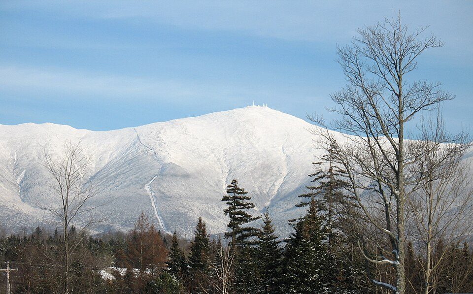
Big draw30 mi MountainMount Washington
31 mi LakeLake Winnipesaukee
13 mi Scenic railwayConway Scenic Railroad
27 mi National forestWhite Mountain National Forest
18 mi Theme parkStory Land
39 mi LandmarkFort GorgesMount Washington: wwoods, CC BY-SA 3.0 · Lake Winnipesaukee: No machine-readable author provided. JohnJHenderson~commonswiki assumed (based o, Public domain · Conway Scenic Railroad: Pi.1415926535, CC BY-SA 3.0 · White Mountain National Forest: Ken Gallager at English Wikipedia, Public domain · Story Land: AnotherMaker, CC BY-SA 4.0 · Fort Gorges: Dirk Ingo Franke, CC BY 3.0
None within 15 miles of Brownfield; the nearest are
About 1 of every 100 Brownfield residents are enrolled in college, against 6 across Maine.
Town in Maine, United States
Brownfield is a town in Oxford County, Maine, United States. The population was 1,631 at the 2020 census. Brownfield is home to the Stone Mountain Arts Center.
From Wikipedia, licensed CC BY-SA 4.0 · facts via Wikidata (CC0)
6 towns share a border with Brownfield.
| Town | ME rank | Overall | Cost | Safety | Schools | Health |
|---|---|---|---|---|---|---|
| Brownfield | — | — | D | — | C+ | C+ |
| Denmark | — | — | C | — | C+ | C+ |
| Hiram | — | — | C− | — | B− | C |
| Fryeburg | #98 | C | C | B+ | C+ | C |
| Porter | — | — | B− | — | B− | C |
Brownfield, Denmark, Hiram and Porter have fewer than 2,500 residents, so they get subject grades but no overall grade. Brownfield, Denmark, Hiram and Porter report no FBI crime data of their own. Compare Brownfield with a neighbor →
Short answers, built from the data on this page.
Yes. Cost of living, which also weighs rents, property taxes and how many households pay 30% or more of their income for housing, grades D.