Wikipedia doesn’t have a history of Bloomington yet. The photos, dates and memories neighbors add here are how it gets written.
Bloomington is an unincorporated community and census-designated place (CDP) located in southeastern Garrett County, Maryland located at the confluence of the North Branch Potomac River and Savage River. It lies to the west of Luke on Maryland Route 135 and is bounded to the northwest by Savage River State Forest. As of the 2010 census the population of Bloomington was 305. Originally known as "Llangollen" when the town's post office was established on December 4, 1872, its name was later changed to "Bloomington". Jennings Randolph Lake to the southwest on the North Branch of the Potomac was completed in 1982 as "Bloomington Lake" but was renamed in 1987 by the United States Congress for We…
Between the 2010 and 2020 censuses its population fell from 305 to 271 (-11%).
Intro from Wikipedia. Population: U.S. Census Bureau.
On the map
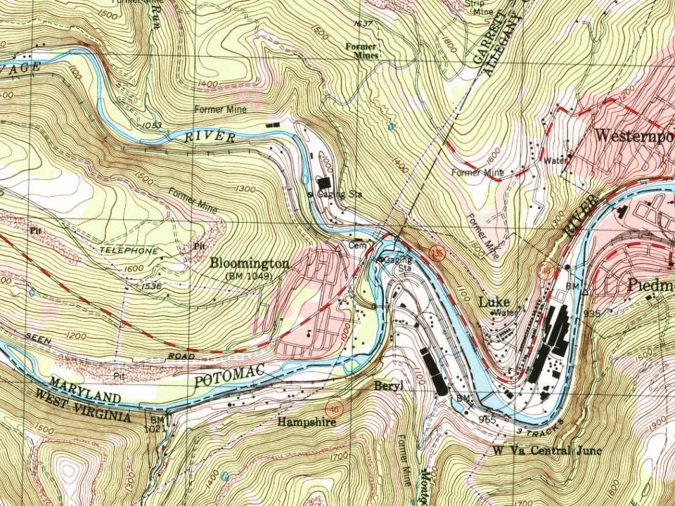
Bloomington on the map, 1919 to 1996
Every edition of the U.S. Geological Survey’s map of Bloomington. Tap a year, or press play to watch the town change.
1919Elk Garden sheet · 1:62,500
U.S. Geological Survey historical topographic maps (public domain), via Esri’s collection of the scans. The red ring marks the center of Bloomington.
From the old history books
What they wrote about Bloomington in 1929
Passages that mention Bloomington, cut from the printed page as they were published.
The genealogy and history of the families of Francis Dodds and Margaret Craig Dodds of Spartanburg, South Carolina and of the Dodds families of Baltimore, Maryland, Bloomington, Indiana, Coles county, Illinois, compiled by Lydia Colby.1929Read the page →
Read the text
12. Clelland Finley Dodds2; b. September 27, 182G; m. Mary E. Orchard of Bloomington, Indiana, July 31, 1851; attended U. of Ind. two years; was a farmer two miles south of Bloomington ten years; was a drygoods mer¬ chant of firm of Dodds and Ketchem of Bloomington six years; mayor of Bloomington, seven years; died July 27, 1894. Mary E. Dodds died June 7, 1910.
Text read by machine from the scan; it may contain errors.
The genealogy and history of the families of Francis Dodds and Margaret Craig Dodds of Spartanburg, South Carolina and of the Dodds families of Baltimore, Maryland, Bloomington, Indiana, Coles county, Illinois, compiled by Lydia Colby.1929Read the page →
Read the text
She was born in Lincoln county, Kentucky, January 13, 1785. At Bloomington, Indiana, they lived on a farm one mile from the court house at Bloomington. Samuel Dodds was a farmer and tanner. He was one of the first trustees of Indiana. University, located at Bloomington, Indiana. He died at Bloomington, Septem¬ ber 15, 1831. Rachel Josephine (Rinehart) Dodds died November 3, 1851. They had eleven children, eight of them born in Lincoln county, Kentucky, and the three youngest in Bloomington, In¬
Text read by machine from the scan; it may contain errors.
Scans and text from the Internet Archive. Books published in 1930 or earlier, which are in the public domain.
Founding dates: Wikidata, Wikipedia, the U.S. post office records of Blevins & Helbock (CC0) and the Census. Homes by year built: Census ACS 2020–24. National Register of Historic Places: National Park Service (list of May 22, 2026). Old photos, postcards and papers: Wikimedia Commons, the Library of Congress and other public archives, credited on each item’s page. Maps: U.S. Geological Survey historical topographic maps (via Esri) and Sanborn fire-insurance maps (Library of Congress). History text and census tables: Wikipedia (CC BY-SA 4.0). Places that used to be: USGS Geographic Names Information System (2021). How TownRatings grades history →
From Wikimedia Commons (2), the National Register of Historic Places (2), Wikidata and Wikipedia for famous people, U.S. Geological Survey historical maps, the USGS Geographic Names Information System and old county and town histories (Internet Archive). Archive images are copied here with their credits and licenses, shown on each photo’s page. Refreshed monthly.




 2021
 2016
