2 places in town are on the National Register, among them a historic district with 42 buildings. Below: 4 old photos and papers from 1899 on and old-book passages.
Founding year: Wikidata. First post office: 1814.The full story ↓
History grade
What drives Conway’s History grade
On its age, its old homes and the National Register, Conway is more historic than 98% of U.S. towns. All 3 inputs are above most U.S. towns; its age ranks highest and its National Register listings lowest.
A+
HistoryA character grade: shown, never part of Conway’s overall grade.
Massachusetts towns list more on the Register than most of the country (a typical Massachusetts town has 46.0 per 10,000 residents, the U.S. 2.4), so Conway’s 239 sits above most of its state (80% of Massachusetts towns have fewer) while its 42 historic buildings outnumber those of 84% of U.S. towns.
NoteThe founding year comes from Wikidata alone; no second source gives 1762.
How sure. Graded on any two of the three inputs instead, the letter would range from A to A+. The pre-1940 share is a Census survey estimate (±9.1 points).
Founding year: Wikidata (other dates in Quick answers). Homes: Census ACS 2020–24. National Register: National Park Service, May 2026 list; each listing counted once (boundary changes and added documentation belong to their listing), and a historic district counts its contributing buildings. How TownRatings grades history →
What stands out about Conway’s past
Read from the archive, the National Register and the record. The page puts what stands out first.
English colonists first settled Conway in 1762 as the southwestern portion of the Town of Deerfield. The town was eventually separated and was officially incorporated in 1767. The town was named after General Henry Seymour Conway, a leader in the British House of Commons during the repeal of the Stamp Act. (Conway, New Hampshire, as well as other towns across the country, were also named for him.) The town was known for its sheep farming and other agrarian pursuits in its early years, with some industry along the South River. This was washed out in a dam break in 1869. Today the town is primarily a farming community.
Passages that mention Conway, cut from the printed page as they were published.
Celebration of the hundredth anniversary of the incorporation of Conway, Massachusetts1867 · page 113Read the page →
Read the text
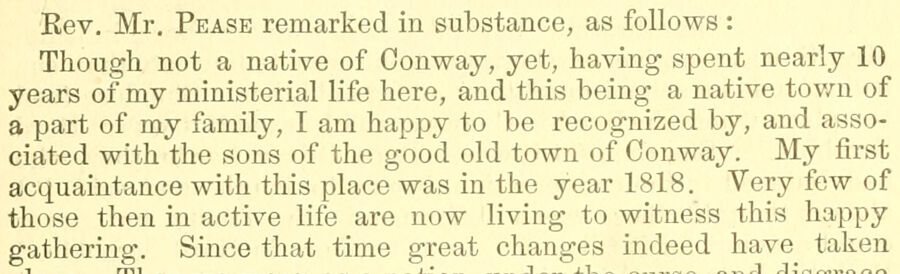
Rev. Mr. Pease remarked in substance, as follows : Though not a native of Conway, yet, having spent nearly 10 years of my ministerial life here, and this being a native tov/n of a part of my family, I am happy to be recognized by, and associated with the sons of the good old town of Conway. My first acquaintance with this place was in the year 1818. Very few of those then in active life are now living to witness this happy gathering. Since that time great changes indeed have taken
Text read by machine from the scan; it may contain errors.
History of Conway (Massachusetts) 1767-19171917 · page 76Read the page →
Read the text
by the community. The town at its annual meeting on March 9, 1868, voted to ask the Legislature for permission to subscribe for stock in a contemplated railroad from Williamsburg through Conway to Shelburne Falls. Different routes through Conway had been considered, but the one most in favor with the surveyors would have located a depot at Burkeville near the lower bridge. The railroad would have crossed South River near the shoe shop, then passing in front of Arms' grove and on the
Text read by machine from the scan; it may contain errors.
History of Conway (Massachusetts) 1767-19171917 · page 135Read the page →
Read the text
The character and achievements of the fathers who founded the town of Conway and its first Christian church permit the hope that their descendants will rise to the full measure of privilege and accomplishment in days to come.
Text read by machine from the scan; it may contain errors.
Celebration of the hundredth anniversary of the incorporation of Conway, Massachusetts1867 · page 130Read the page →
Read the text
on public days there were frequent contests between Deerfield and the neighboring towns, for the possession of it. On one of these occasions the cannon was missing from Deerfield, and early in the morning its echoes were heard from Conway ; the young men of Deerfield mustered in battle array, mounted and armed, and in military order marched to Conway to recapture the cannon or perish in the attempt ; the men of Conway equally stern in the resolve to keep the trophy, at least for that day, had drag-
Text read by machine from the scan; it may contain errors.
Scans and text from the Internet Archive. Books published in 1930 or earlier, which are in the public domain.
By decade
Conway, decade by decade
3 decades in the archive, from the 1890s to the 1930s. Scroll each row; tap a photo for its story.
Nothing in the archives for these yearsWeddings on Main Street, storms, parades, school pictures, the old store. If it’s in your family album, it belongs here.
In 1762, according to Wikidata. Conway’s post office opened in 1814.
How does Conway rank for history?
Conway is more historic than 98% of U.S. towns. The History grade combines the town’s founding era, the share of homes built before 1940 and its National Register listings. It’s a character grade, so it isn’t part of the overall grade. How it works.
What is on the National Register in Conway?
Two places: the Burkeville Covered Bridge (listed 1988) and the Conway Center Historic District (1999).
How old are the homes in Conway?
34% of Conway’s homes were built before 1940 (Census estimate, ±9.1 points), against a typical 21% for a Massachusetts town; the median home was built in 1976.
Founding dates: Wikidata, Wikipedia, the U.S. post office records of Blevins & Helbock (CC0) and the Census. Homes by year built: Census ACS 2020–24. National Register of Historic Places: National Park Service (list of May 22, 2026). Old photos, postcards and papers: Wikimedia Commons, the Library of Congress and other public archives, credited on each item’s page. Maps: U.S. Geological Survey historical topographic maps (via Esri) and Sanborn fire-insurance maps (Library of Congress). History text and census tables: Wikipedia (CC BY-SA 4.0). Places that used to be: USGS Geographic Names Information System (2021).
From Wikimedia Commons (4), Wikidata (2), the National Register of Historic Places (2), Wikipedia, Wikidata and Wikipedia for famous people, the US Post Offices dataset (Blevins & Helbock), the USGS Geographic Names Information System and old county and town histories (Internet Archive). Archive images are copied here with their credits and licenses, shown on each photo’s page. Refreshed monthly.




 1907–1915

