
LAMap-doton-Brownfields, 2004
Brownfields’s story
Brownfields in pictures
Census counts: 5,229 in 1990, 5,145 in 2020. The archive holds 1 old photo or paper going back to 2004 and 6 maps from 1939 on.
Explore the history →Each edition grades its towns against each other only.
A town of 4,261.
Brownfields grades D− overall, 154th of 161 graded towns in Louisiana, mostly because of health and incomes. Residents are less healthy than 97% of U.S. towns on CDC estimates. The median household income is $66K, and 24% of residents live below the poverty line. One bright spot: its schools outperform 62% of the state's. Most errands need a car: it is less walkable than 95% of U.S. towns. Among 161 Louisiana towns, just 5 have a lower share of working residents who work in town than Brownfields. FEMA rates its natural-hazard risk higher than 79% of U.S. communities, with inland flooding at the top.
Where Brownfields’s working residents go each day. Line width shows the share.
Census LEHD 2023
Each subject compared with towns across the country (schools within Louisiana), ordered by how far Brownfields is from typical.
How TownRatings grades towns →
Census counts: 5,229 in 1990, 5,145 in 2020. The archive holds 1 old photo or paper going back to 2004 and 6 maps from 1939 on.
Explore the history →Museums, parks, gardens and other places to visit around Brownfields. Close and well known come first.
 10 mi Stadium & arenaTiger Stadium
 8 mi MuseumUSS Kidd
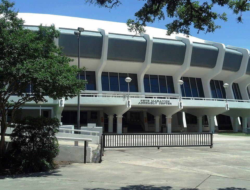 10 mi Stadium & arenaPete Maravich Assembly Center15 mi Theme parkBlue Bayou and Dixie Landin'
 3 mi Zoo & aquariumBaton Rouge Zoo
 8 mi MuseumShaw Center for the Arts
Tiger Stadium: Daniel Foster, CC BY-SA 2.0 · USS Kidd: Cobatfor, CC BY-SA 3.0 · Pete Maravich Assembly Center: Spatms, CC BY-SA 3.0 · Baton Rouge Zoo: Kkmurray, CC BY 2.5 · Shaw Center for the Arts: UrbanPlanet BR (talk), CC BY-SA 3.0
Brownfields is unincorporated, so East Baton Rouge Parish and regional agencies provide most services.
EPA SDWIS (Oct 9, 2026) · HIFLD + EIA-861 2025 · Census 2020 ZCTAs · NCES 2024–25 · registration: vote.gov, updated Aug 3, 2026.
Ordered by what stands out in Brownfields.
Brownfields looks healthier within Louisiana than nationally and sends most of its workers to Baton Rouge and beyond.
Within Louisiana it is less healthy than 70% of the 161 graded towns: much of Louisiana scores lower on these measures.
22% of adults have diabetes in Brownfields, against 16% in Louisiana’s towns and 12% across U.S. towns. 48% of adults sleep under 7 hours in Brownfields. Brownfields beats the Louisiana average on 4 of 32 CDC measures and trails it on 19.
| Brownfields | Louisiana towns | U.S. towns | |
|---|---|---|---|
| Diabetes (CDC PLACES) | 22% | 16% | 12% |
| Sleep under 7 hours (CDC PLACES) | 48% | 42% | 36% |
| High blood pressure (CDC PLACES) | 53% | 44% | 35% |
| Food insecurity (CDC PLACES) | 36% | 26% | 14% |
| What stands out | Brownfields | LA |
|---|---|---|
| Fewer binge drinkers | 12.7% | 16.9% |
| Fewer adults who have had cancer | 6.6% | 7.5% |
| More adults facing a utility shut-off | 22% | 12.4% |
CDC PLACES 2025 · modeled estimates for adults · CMS · HRSA
Its public schools are run by the East Baton Rouge Parish school district. Its one school is below.
| School | Level | Students | Letter |
|---|---|---|---|
| Brownfields Elementary SchoolLargest public elementary schoolGrades PK–5 | Grades PK–5 | 368 | B− |
NCES · EDFacts · graded within LA on state tests and graduation
FEMA National Risk Index · OpenFEMA
Brownfields has 340 jobs for its 2,099 working residents: even if every job went to a resident, most would still commute out.
Most working residents leave Brownfields for work: only 1% work in town. Since 2013, Brownfields has lost 54 jobs, to 340 in 2023. At 27 minutes, Brownfields’ average trip to work is above both Louisiana’s towns (24 minutes) and U.S. towns (25 minutes).
| Brownfields | Louisiana towns | U.S. towns | |
|---|---|---|---|
| Average trip to work | 27 minutes | 24 minutes | 25 minutes |
| Median household income | $66,000 | $56,000 | $80,000 |
Census LEHD 2023 · ACS
Brownfields has warm winters and warm summers, with plenty of rain. Brownfields’ July high is 92°F.
NOAA U.S. Climate Normals, 1991–2020
Adults 35 to 64 are 43% of residents (37% statewide); children under 18 are 19% of residents (24% statewide). 20% of adults 25 and older have a bachelor’s degree or more, vs 27% across Louisiana.
| Brownfields | Louisiana towns | U.S. towns | |
|---|---|---|---|
| Bachelor’s degree or more, 25+ | 20% | 20% | 29% |
| Median age | 40.4 years | 37.8 years | 40.5 years |
| Aged 65 or older | 16% | 17% | 18% |
55% women, 45% men
That’s an even split within the survey’s margin of ±5.3 points. Across Louisiana, 51.1% of residents are women.
| Brownfields | LA | U.S. | |
|---|---|---|---|
| Under 10 | 7.3% | 12.6% | 11.6% |
| 10 to 17 | 11.7% | 10.9% | 10.3% |
| 18 to 24 | 7.1% | 9.1% | 9.1% |
| 25 to 34 | 14.4% | 13.3% | 13.7% |
| 35 to 44 | 12.8% | 13.3% | 13.2% |
| 45 to 54 | 10.3% | 11.5% | 12.2% |
| 55 to 64 | 19.9% | 12.6% | 12.7% |
| 65 to 74 | 9% | 10.2% | 10.2% |
| 75 and older | 7.4% | 6.5% | 7% |
| No diploma | 19.3% | 12.7% | 10.4% |
| High school | 30% | 32.5% | 26% |
| Some college | 19.7% | 20.4% | 19.1% |
| Associate’s | 11.2% | 7.3% | 8.8% |
| Bachelor’s | 14.3% | 17% | 21.6% |
| Graduate | 5.5% | 10.1% | 14.1% |
U.S. Census Bureau · ACS 2020-2024 5-year estimates · in a town of 4,300, single groups can be off by several points
0.7 miles of trail in 2 parks and preserves.
| Brownfields | Louisiana towns | U.S. towns | |
|---|---|---|---|
| Miles of trail per square mile | 0.2 miles per square mile | 0.2 | 0.4 |
| Conserved land | 3.3% | 1.2% | 4.3% |
| Biggest places to walk | Trails | Acres |
|---|---|---|
| 1. Hooper Road Park | 0.6 mi | 32 |
| 2. Laurens Henry Cohn, Sr. Memorial Plant Arboretum | 0.1 mi | 13 |
Trails & parks © OpenStreetMap contributors · Conserved land: USGS PAD-US
Zillow Home Value Index · Redfin Data Center
6 within 15 miles of the center of Brownfields
About 3 of every 100 Brownfields residents are enrolled in college, against 6 across Louisiana.
Census-designated place in Louisiana, United States
Brownfields is an unincorporated area and census-designated place (CDP) in East Baton Rouge Parish, Louisiana, United States. As of the 2020 census, Brownfields had a population of 5,145. It is part of the Baton Rouge metropolitan statistical area.
From Wikipedia, licensed CC BY-SA 4.0 · facts via Wikidata (CC0)
3 towns share a border with Brownfields.
Baker next door grades lower for schools (D to Brownfields’s B) and higher for cost of living (B+ to C+).
| Town | LA rank | Overall | Cost | Safety | Schools | Health |
|---|---|---|---|---|---|---|
| Brownfields | #154 | D− | C+ | — | B | D− |
| Central | #9 | B+ | C | — | A | B+ |
| Baker | #156 | D− | B+ | C | D | D |
| Baton Rouge | #105 | C− | C+ | — | B− | C− |
Brownfields, Central and Baton Rouge report no FBI crime data of their own. Compare Brownfields with a neighbor →
Short answers, built from the data on this page.
Brownfields grades D− overall, better than 3% of U.S. towns and #154 of 161 in Louisiana. It grades D− for health and B for schools. Health is its weak spot, with a D−.
That is 3 years of the area's median household income ($69,599 across the Baton Rouge, LA metro area). Cost of living, which also weighs rents, property taxes and how many households pay 30% or more of their income for housing, grades C+.


