Wolf River Township’s post office opened in 1865, and 61% of its homes were built before 1940
Its Register listings are the George Hanson Barn, the John R. Hale Barn and the John Streib Barn. Its Register listings are the George Hanson Barn, the John R. Hale Barn and the John Streib Barn. Below: maps from 1885 on and old-book passages.
The Wolf River Township post office opened in 1865, the earliest record of the town by name. Three smaller post offices, Wolf River (1865), East Norway (1871) and Moray (1894), opened inside today’s town and later closed.
2020 census: 350161 years
Founding year: the first Wolf River Township post office (Blevins & Helbock, CC0).
What stands out about Wolf River Township’s past
Read from the archive, the National Register and the record. The page puts what stands out first.
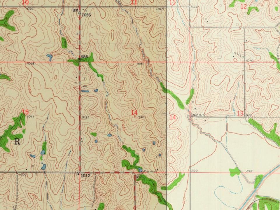
Every edition of the U.S. Geological Survey’s map of Wolf River Township. Tap a year, or press play to watch the town change.
1885Atchison sheet · 1:125,000
U.S. Geological Survey historical topographic maps (public domain), via Esri’s collection of the scans. The red ring marks the center of Wolf River Township.
Places that used to be
Lost post offices, old corners, places now gone and burying grounds
Three other post offices opened and closed inside today’s town.
Wolf River
1865–1866
East Norway
1871–1894
Moray
1894–1938
18601940today
Hamlets and corners on the map
Moray
Gone or out of use
Herzing SchoolschoolHoopers Ford SchoolschoolIolalocaleLaverentz SchoolschoolMarcelllocaleRatcliffelocaleStar SchoolschoolWolf River Schoolschool
4cemeteries and burying grounds inside Wolf River Township
BitnerBurrellOak HillWolf River
US Post Offices dataset (Blevins & Helbock, CC0). Places and cemeteries from the USGS Geographic Names Information System (2021).
The story so far
Wolf River Township, in brief
Wikipedia doesn’t have a history of Wolf River Township yet. The photos, dates and memories neighbors add here are how it gets written.
Wolf River Township is a township in Doniphan County, Kansas, United States. As of the 2020 census, its population was 350.
Its first post office opened in 1865. Between the 2010 and 2020 censuses its population fell from 370 to 350 (-5%).
Intro from Wikipedia. Population: U.S. Census Bureau.
From the old history books
What they wrote about Wolf River Township in 1868
Passages that mention Wolf River Township, cut from the printed page as they were published.
Doniphan County, Kansas, history and directory for 1868-91868 · page 267Read the page →
Read the text
District No. 18. Has one good school house, situated 4^ miles south of Highland, in Wolf River Township, has 43 scholars in district. District No. 19. Has one school house, situated 7 miles south of Highland, in Wolf River Township, has an attendance of about 13 scholars.
Text read by machine from the scan; it may contain errors.
Doniphan County, Kansas, history and directory for 1868-91868 · page 269Read the page →
Read the text
District No. 45. Has one school house, situated 4 miles southwest of Highland, in Wolf River Township, average attendance 23 scholars. District No. — Has one school house, situated at Columbus, in Bur Oak Township, about 75 scholars in district, attendance 40.
Text read by machine from the scan; it may contain errors.
Scans and text from the Internet Archive. Books published in 1930 or earlier, which are in the public domain.
Timeline
Wolf River Township, 1865 to 1938
Woven from the archive, old maps, post office records, the National Register and the people born here.
Founding dates: Wikidata, Wikipedia, the U.S. post office records of Blevins & Helbock (CC0) and the Census. Homes by year built: Census ACS 2020–24. National Register of Historic Places: National Park Service (list of May 22, 2026). Old photos, postcards and papers: Wikimedia Commons, the Library of Congress and other public archives, credited on each item’s page. Maps: U.S. Geological Survey historical topographic maps (via Esri) and Sanborn fire-insurance maps (Library of Congress). History text and census tables: Wikipedia (CC BY-SA 4.0). Places that used to be: USGS Geographic Names Information System (2021). How TownRatings grades history →
From the National Register of Historic Places (3), U.S. Geological Survey historical maps, the US Post Offices dataset (Blevins & Helbock), the USGS Geographic Names Information System and old county and town histories (Internet Archive). Archive images are copied here with their credits and licenses, shown on each photo’s page. Refreshed monthly.