Guest, Sign inJoin

Post to White Cloud

We’ll email a one-tap link to publish your post. No password, and nothing is public until you click it.
Already a member? Sign in
–Not graded
History · White Cloud

White Cloud’s post office opened in 1855, and 26% of its homes were built before 1940

2 places in town are on the National Register, among them a historic district with 67 buildings. Below: 11 old photos and papers, maps from 1884 on, and the census since 1860.

1855first post office
2on the National Register
26%homes built before 1940
11old photos & papers
From White Cloud’s archive · credits on each photo
Quick answers

How White Cloud began, and where its name came from

When was White Cloud founded?

1855

The White Cloud post office opened in 1855, the earliest record of the town by name.

First census: 251 in 18602020 census: 115171 years

How did White Cloud get its name?

White Cloud was named for Francis White Cloud, a son of Chief White Cloud of the Iowa people.

Founding year: the first White Cloud post office (Blevins & Helbock, CC0). Name: Wikipedia, licensed CC BY-SA 4.0.The full story ↓

What stands out about White Cloud’s past

Read from the archive, the National Register and the record. The page puts what stands out first.

★ What stands out · On the map

White Cloud on the map, 1885 to 1990

Every edition of the U.S. Geological Survey’s map of White Cloud. Tap a year, or press play to watch the town change.

White Cloud on the 1885 USGS mapWhite Cloud on the 1893 USGS mapWhite Cloud on the 1959 USGS mapWhite Cloud on the 1985 USGS mapWhite Cloud on the 1990 USGS map1885Atchison sheet · 1:125,000

U.S. Geological Survey historical topographic maps (public domain), via Esri’s collection of the scans. The red ring marks the center of White Cloud.

On the National Register

2 listings protect 68 historic buildings

The country’s official list of buildings and places worth saving.

places listed
2
National Historic Landmarks
0
none yet
historic buildings protected
68
each building in a district counts
first listed
1971
Poulet House
All 2 listings

National Park Service, National Register of Historic Places. Photos from Wikimedia Commons, credited on each place’s page.

People over time

White Cloud, census by census

02004006008001,0001,200190019502000Peak: 1,119

Peaked at 1,119 in 1910; 115 people lived here in 2020.

17 censuses, 1860–2020.

U.S. Census Bureau decennial counts, from the census table on White Cloud’s Wikipedia page.

The story

How White Cloud came to be

From Wikipedia’s history of White Cloud.

Read it all →

The first post office at White Cloud was established in July, 1855.

In 1857, the town site was purchased by John Utt and Enoch Spaulding, two land promoters from Oregon, Missouri, who then sold lots in the town. White Cloud prospered by taking advantage of steamboat traffic on the nearby Missouri River.

In 1913, ten-year-old Wilbur Chapman of White Cloud gained widespread publicity after raising and selling a pig for $25, which he donated to the American Mission to Lepers. An obelisk-shaped monument was installed in front of the Community Christian Church in White Cloud in Chapman's honor.

Text from Wikipedia, licensed CC BY-SA 4.0.

From the old history books

What they wrote about White Cloud, 1868–1905

Passages that mention White Cloud, cut from the printed page as they were published.

As yet the Missouri River affords the only channel of commerce to White Cloud ; but the surveyed route of the Atchison and Nebraska Railroad passes through the town, and the railroad company promise to have the cars running over the road to the Nebraska line, before the close of the year 1868. Her …
Doniphan County, Kansas, history and directory for 1868-91868 · page 286Read the page →
Read the text

As yet the Missouri River affords the only channel of commerce to White Cloud ; but the surveyed route of the Atchison and Nebraska Railroad passes through the town, and the railroad company promise to have the cars running over the road to the Nebraska line, before the close of the year 1868. Her futm*e, therefore, seems bright, and she bids fair to remain one of the richest and most thriving localities in the magnificent county of Doniphan.

Text read by machine from the scan; it may contain errors.
"The bluffs above White Cloud slid down upon the railroad track. The depot at Wathena was swept away entire.
Gray's Doniphan County history. A record of the happenings of half a hundred years1905 · page 128Read the page →
Read the text

"The bluffs above White Cloud slid down upon the railroad track. The depot at Wathena was swept away entire.

Text read by machine from the scan; it may contain errors.
north, forming a junction with the St. Joseph and Denver City Railroad at Troy ; thence northwest, touching the Missouri River again, near the mouth of Wolf River, and following the river to Iowa Point, and from thence along the foot of the bluffs, to White Cloud, and thence into Nebraska. This wil…
Doniphan County, Kansas, history and directory for 1868-91868 · page 283Read the page →
Read the text

north, forming a junction with the St. Joseph and Denver City Railroad at Troy ; thence northwest, touching the Missouri River again, near the mouth of Wolf River, and following the river to Iowa Point, and from thence along the foot of the bluffs, to White Cloud, and thence into Nebraska. This will give us about thirty miles of railroad running north and south through the most fertile portion of the State, and there is not much doubt that the road will be speedily completed, as it is em-

Text read by machine from the scan; it may contain errors.

Scans and text from the Internet Archive. Books published in 1930 or earlier, which are in the public domain.

Timeline

White Cloud, 1855 to 1974

Woven from the archive, old maps, post office records, the National Register and the people born here.

  1. 19th century
  2. 1855Post officeThe White Cloud post office opens
  3. 1868BuiltWhite Cloud Historic District is built
  4. 1885On the mapFirst mapped by the U.S. Geological Survey
  5. 20th century
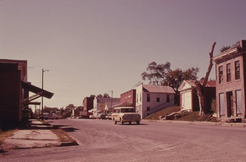
  6. 1900In the archiveBluff view
  7. 1910CensusPopulation peaks at 1,119
  8. 1974In the archiveA MISSOURI RIVER FISHERMAN SHOWS OFF HIS HOMEMADE CARP TRAP AT WHITE CLOUD, KANSAS, NEAR …
By decade

White Cloud, decade by decade

2 decades in the archive, from the 1900s to the 1970s. Scroll each row; tap a photo for its story.

Every building

White Cloud, building by building, 1884–1905

Fire insurance maps drew every building, what it was made of and what it was used for, so insurers could price the risk of fire. Pick a year, then a sheet.

White Cloud fire insurance map, 1884, sheet 11884Sheet 1 of 2
Edition
BrickWoodStone

Sanborn Map Company, via the Library of Congress. Editions published in 1930 or earlier, which are in the public domain.

Then & now

Stand where they stood

No then-and-now pairs yet. Take a photo from the same spot as an old one and they appear here side by side.

Bluff view
Retake this viewBluff view, 1900

Find the spot, match the angle, and add your photo. It becomes the first then-and-now pair on White Cloud’s page.

Retake this view · +15
Help out

Finish White Cloud’s story

Most archives stop around 1920. The photos from after that are in family albums, not libraries.

Decades since 1900 with photos
00s10s20s30s40s50s60s70s80s90s
2 of 10 decades. The empty ones are waiting for someone’s album.

Questions about White Cloud’s history

What year was White Cloud founded?

The White Cloud post office opened in 1855, the earliest record of the town by name (U.S. post office records).

What is on the National Register in White Cloud?

Two places: the White Cloud Historic District (listed 1996) and the Poulet House (1971).

Memory lane

What the archives can’t tell you, neighbors can.

Town Square →
Start a conversation
Sources

Where this page comes from

Founding dates: Wikidata, Wikipedia, the U.S. post office records of Blevins & Helbock (CC0) and the Census. Homes by year built: Census ACS 2020–24. National Register of Historic Places: National Park Service (list of May 22, 2026). Old photos, postcards and papers: Wikimedia Commons, the Library of Congress and other public archives, credited on each item’s page. Maps: U.S. Geological Survey historical topographic maps (via Esri) and Sanborn fire-insurance maps (Library of Congress). History text and census tables: Wikipedia (CC BY-SA 4.0). Places that used to be: USGS Geographic Names Information System (2021). How TownRatings grades history →

From Wikimedia Commons (10), the Library of Congress (1), Wikidata (1), the National Register of Historic Places (2), Wikipedia, U.S. Geological Survey historical maps, U.S. Census counts (via Wikipedia), the US Post Offices dataset (Blevins & Helbock), the USGS Geographic Names Information System, Sanborn fire insurance maps (Library of Congress) and old county and town histories (Internet Archive). Archive images are copied here with their credits and licenses, shown on each photo’s page. Refreshed monthly.