The Potwin post office opened in 1885, the earliest record of the town by name. Another post office, Ayr (1875), opened inside today’s city and later closed.
First census: 249 in 19102020 census: 421141 years
Founding year: the first Potwin post office (Blevins & Helbock, CC0).The full story ↓
What stands out about Potwin’s past
Read from the archive, the National Register and the record. The page puts what stands out first.
Potwin was incorporated as a town on April 8, 1885. This land, owned by Charles Potwin, whereby the town received its name, became a station for the Missouri Pacific Railroad, instigated by William I. Joseph, known as the Father of Potwin.
Joseph came from West Virginia and, as more settlers arrived, became interested in a railroad to serve the area. After much diligent pursuit, the station was built and Joseph, a land agent for Charles Potwin, began development of a town site around the Potwin station. He opened a land office where the Potwin grocery now stands.
A post office was established in Ayr (an extinct town) on July 12, 1875, but it was moved to Potwin on September 22, 1885.
Passages that mention Potwin, cut from the printed page as they were published.
History of Butler County Kansas1916 · page 190Read the page →
Read the text
changed to run from Newton to El Dorado, and another postoffice was established in the township at the house of W. H. Randall. Office was named Ayr and Mrs. Randall was appointed postmaster. When the town of Potwin was started, the office was moved there and the name chang-ed to Potwin. The new town of Plum Grove on the west side of the Whitewater had two general stores, a drug store and a blacksmith shop. Stark M. Spencer was one of the merchants, M. C. Snorf the other. Dr. I. V. Davis had the drug store and practiced medicine, and
Text read by machine from the scan; it may contain errors.
life came from the lips of Rev. Isaac Mooney, and it gave me a favorable impression of the ministry. It was in the little old Diamond Creek school house that stood in what is now the western edge of the town of Potwin. I was about six years of age, and it was before the days of churches in northwest Butler. The country was sparsely settled, but the neighbors came from great distances to hear the sermon, which was the first to be preached in the community for a long time. I well remember the particularity with which I was cautioned by my good
Text read by machine from the scan; it may contain errors.
Scans and text from the Internet Archive. Books published in 1930 or earlier, which are in the public domain.
Timeline
Potwin, 1875 to 1960
Woven from the archive, old maps, post office records, the National Register and the people born here.
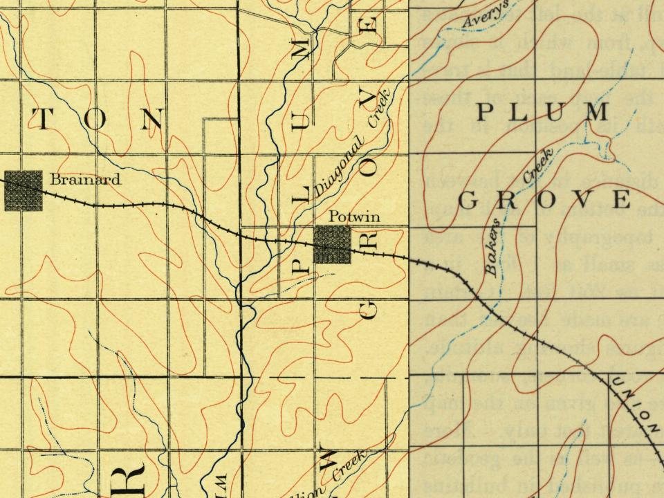
Founding dates: Wikidata, Wikipedia, the U.S. post office records of Blevins & Helbock (CC0) and the Census. Homes by year built: Census ACS 2020–24. National Register of Historic Places: National Park Service (list of May 22, 2026). Old photos, postcards and papers: Wikimedia Commons, the Library of Congress and other public archives, credited on each item’s page. Maps: U.S. Geological Survey historical topographic maps (via Esri) and Sanborn fire-insurance maps (Library of Congress). History text and census tables: Wikipedia (CC BY-SA 4.0). Places that used to be: USGS Geographic Names Information System (2021). How TownRatings grades history →
From Wikimedia Commons (3), Wikipedia, U.S. Geological Survey historical maps, U.S. Census counts (via Wikipedia), the US Post Offices dataset (Blevins & Helbock), the USGS Geographic Names Information System and old county and town histories (Internet Archive). Archive images are copied here with their credits and licenses, shown on each photo’s page. Refreshed monthly.



 2015
 2010
 2004


