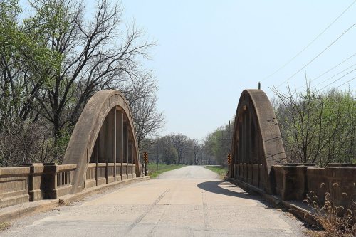

Mine Creek Bridge · National Register of Historic Places
Potosi Township’s story
167 years in pictures
The archive holds 3 maps from 1958 on.
2 places on the National Register of Historic Places.
- 1859Potosi Township is settled
Each edition grades its towns against each other only.
Home to 2 places on the National Register of Historic Places.
Potosi Township’s best subject grades are an A+ for cost of living and an A− for civic life; its weakest is a D for schools. On cost of living, just 29 of Kansas’ 373 towns do better. 16% of the land in Potosi Township is conserved, above both Kansas’ towns (2.1%) and U.S. towns (4.3%). The biggest park or preserve is Marais des Cygnes National Wildlife Refuge, at 2,853 acres. Potosi Township has fewer than 2,500 residents, so it gets subject grades but no overall grade.
Where Potosi Township beats most towns.
Each subject compared with towns across the country (schools within Kansas), ordered by how far Potosi Township is from typical.
How TownRatings grades towns →
The archive holds 3 maps from 1958 on.
2 places on the National Register of Historic Places.
Who provides power, water and the rest in Potosi Township, and how to reach them.
EPA SDWIS (Oct 9, 2026) · HIFLD + EIA-861 2025 · Census 2020 ZCTAs · NCES 2024–25 · registration: vote.gov, updated Nov 18, 2024.
Ordered by what stands out in Potosi Township.
Its two schools are below. The public schools here belong to the Pleasanton school district. Public school enrollment in Potosi Township: 362 students across 2 schools.
| School | Level | Students | Letter |
|---|---|---|---|
| Pleasanton ElemLargest public elementary schoolGrades PK–6 | Grades PK–6 | 200 | C |
| Pleasanton HighLargest public high schoolGrades 7–12 | Grades 7–12 | 162 | D− |
NCES · EDFacts · graded within KS on state tests and graduation
Walkers can cover 2.6 miles of trail in 3 parks and preserves. The trail density for Potosi Township comes to 0.1 miles per square mile, near the Kansas town median (0.3) and below the median of U.S. towns (0.4). Parks and preserves locally: 3, covering 5,254 acres.
| Biggest places to walk | Trails | Acres |
|---|---|---|
| 1. Marais des Cygnes National Wildlife Refuge | 0.9 mi | 2,853 |
| 2. Marais des Cygnes Wildlife Area | 0.4 mi | 2,399 |
| 3. Dunlap Park | — | 2 |
Trails & parks © OpenStreetMap contributors · Conserved land: USGS PAD-US
In Potosi Township, the July high is 90°F.
NOAA U.S. Climate Normals, 1991–2020
For half of commuters, work is under 39 miles away. The mean commuting time in Potosi Township is 31 minutes. Commuting out is the norm locally: 14% of working residents work locally. Jobs based in Potosi Township grew to 548 in 2023, 142 more than in 2013.
| Potosi Township | Kansas towns | U.S. towns | |
|---|---|---|---|
| Average trip to work | 31 minutes | 20 minutes | 25 minutes |
| Median household income | $61,000 | $73,000 | $80,000 |
| Below the poverty line | 6.9% | 9.1% | 9.6% |
| Working residents who work in town | 14% | 15% | 8% |
Census LEHD 2023 · ACS
Potosi Township: 17% of adults smoke cigarettes. Among adults here, 29% feel lonely.
| Potosi Township | Kansas towns | U.S. towns | |
|---|---|---|---|
| Feel lonely (CDC PLACES) | 29% | 31% | 33% |
| Smoke cigarettes (CDC PLACES) | 17% | 15% | 14% |
| Sleep under 7 hours (CDC PLACES) | 34% | 35% | 36% |
| Get no exercise (CDC PLACES) | 27% | 26% | 25% |
| What stands out | Potosi Township | KS |
|---|---|---|
| More older adults who have lost all their teeth | 14.2% | 11.3% |
| More adults with COPD | 8.3% | 6.7% |
| More adults with arthritis | 30.3% | 25.5% |
CDC PLACES 2025 · modeled estimates for adults · CMS · HRSA
Storm and flood damage is expected to run lower than in 51% of U.S. communities. FEMA puts 50% of Potosi Township’s expected hazard losses down to inland flooding, and 15% to tornadoes.
FEMA National Risk Index · OpenFEMA
None within 15 miles of Potosi Township; the nearest are
About 5 of every 100 Potosi Township residents are enrolled in college, against 7 across Kansas.
Township in Linn County, Kansas, U.S.
Potosi Township is a township in Linn County, Kansas, United States. As of the 2020 census, its population was 1,876.
From Wikipedia, licensed CC BY-SA 4.0 · facts via Wikidata (CC0)
4 towns share a border with Potosi Township.
| Town | KS rank | Overall | Cost | Safety | Schools | Health |
|---|---|---|---|---|---|---|
| Potosi Township | — | — | A+ | — | D | B− |
| Valley Township | — | — | — | — | — | — |
| Paris Township | — | — | — | — | — | — |
| Sheridan Township | — | — | — | — | — | — |
Potosi Township has fewer than 2,500 residents, so it gets subject grades but no overall grade. Potosi Township reports no FBI crime data of its own. Valley Township, Paris Township and Sheridan Township aren’t graded (fewer than 1,000 residents, or not enough data). Compare Potosi Township with a neighbor →
Short answers, built from the data on this page.
Home to 2 places on the National Register of Historic Places.
Not for the area. Cost of living, which also weighs rents, property taxes and how many households pay 30% or more of their income for housing, grades A+.