Lawrence dates to 1854, and 66 of its places are on the National Register
More historic than 65% of U.S. towns · #54 of 151 in Kansas. What drives it
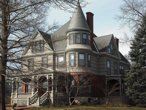
Most of Lawrence was built recently: 10% of its homes predate 1940 and the median home dates from 1988. 66 places in town are on the National Register, among them the Haskell Institute, a National Historic Landmark, and ten historic districts with 426 buildings between them. Below: 5 old photos and papers, maps from 1883 on, and the census since 1860.
Founding year: Wikidata. First post office: 1855.The full story ↓
History grade
What drives Lawrence’s History grade
On its age, its old homes and the National Register, Lawrence is more historic than 65% of U.S. towns, #54 of 151 in Kansas. Its National Register listings hold the grade up; its age pulls it down.
B+
HistoryA character grade: shown, never part of Lawrence’s overall grade.
Kansas towns list more on the Register than most of the country (a typical Kansas town has 5.1 per 10,000 residents, the U.S. 2.4), so Lawrence’s 51.0 sits above most of its state (91% of Kansas towns have fewer) while its 490 historic buildings outnumber those of 97% of U.S. towns.
How sure. Graded on any two of the three inputs instead, the letter would range from C to A−. The pre-1940 share (±1.4 points) is firm at this size. Two sources give 1854.
Founding year: Wikidata (other dates in Quick answers). Homes: Census ACS 2020–24. National Register: National Park Service, May 2026 list; each listing counted once (boundary changes and added documentation belong to their listing), and a historic district counts its contributing buildings. How TownRatings grades history →
What stands out about Lawrence’s past
Read from the archive, the National Register and the record. The page puts what stands out first.
The country’s official list of buildings and places worth saving. One is a National Historic Landmark, the highest tier. Boundary changes and added documentation are counted with their listing.
National Park Service, National Register of Historic Places. Photos from Wikimedia Commons, credited on each place’s page.
Places that used to be
Lost post offices, old corners, places now gone and burying grounds
Lawrence’s post office has been open since 1855. Another post office, North Lawrence, opened and closed inside today’s town.
Lawrence
1855–today
North Lawrence
1872–1885
18501940today
Hamlets and corners on the map
Broken Arrow ParkBrookwood Mobile Home ParkEasy Living Mobile Home ParkGaslight Village Mobile Home ParkHarper Woods Mobile Home ParkMobile Village II Mobile Home ParkNoriaPine Hills Mobile Home ParkRiverside Mobile Home Park
Gone or out of use
Brackett SchoolschoolIndia-Kaw Valley Elementary SchoolschoolLawrence Alternative High SchoolschoolLearnard StationlocaleLincoln SchoolschoolRiverside Elementary SchoolschoolWakarusa Stationlocale
8cemeteries and burying grounds inside Lawrence
Haskell Indian Nations University HaskellHenry T DavisMaple GroveMemorial ParkMount Calvary CatholicOak HillPioneerPioneer
US Post Offices dataset (Blevins & Helbock, CC0). Places and cemeteries from the USGS Geographic Names Information System (2021).
The Kaw people, also known as the Kansa, settled the region including what is now Lawrence in the late 17th or early 18th century. A series of treaties with the U.S. government compelled the Kaw to relinquish the land to the Shawnee and their Indian Reservation, established in 1830. The Kansas Territory was established in May 1854. During this period, the Oregon Trail ran parallel to the Kansas River, roughly through the area where Lawrence is now. A hill in the area, then known as Hogback Ridge and now known as Mount Oread, which sits on the water divide separating the Kansas and Wakarusa River, was used as a landmark and outlook by those on the trail. While the territory was technically closed to settlement until 1854, there were a few "squatter settlements" in the area, especially just north of the Kansas River.
Late in the autumn her master offered a large reward for her arrest and return. It was decided to make a test case of it, and show that a slave could be taken from Lawrence and returned to slavery in Missouri. The United States marshal, with deputies and detectives, came stealthily to. Lawrence, and set themselves to work to locate and capture this woman.
Text read by machine from the scan; it may contain errors.
As a matter of fact there had been no general resistance to the execution of the laws. The rescue of Branson was a solitary case, and belonged to the neighborhood where it occurred. There had never been any resistance in Lawrence, and there would not have been. Sheriff Jones could have come into Lawrence at any time, and made any arrests for which he had any legal authority. He was several times in Lawrence alone while he was making these extensive prepa-
Text read by machine from the scan; it may contain errors.
Scans and text from the Internet Archive. Books published in 1930 or earlier, which are in the public domain.
Timeline
Lawrence, 1854 to 1961
Woven from the archive, old maps, post office records, the National Register and the people born here.
Every edition of the U.S. Geological Survey’s map of Lawrence. Tap a year, or press play to watch the town change.
1950Lawrence East sheet · 1:24,000
U.S. Geological Survey historical topographic maps (public domain), via Esri’s collection of the scans. The red ring marks the center of Lawrence.
Every building
Lawrence, building by building, 1883–1918
Fire insurance maps drew every building, what it was made of and what it was used for, so insurers could price the risk of fire. Pick a year, then a sheet.
In 1854, according to Wikidata. Lawrence’s post office opened in 1855, and the census of 1860 counted 1,645 people here.
How does Lawrence rank for history?
Lawrence is more historic than 65% of U.S. towns, #54 of 151 in Kansas. The History grade combines the town’s founding era, the share of homes built before 1940 and its National Register listings. It’s a character grade, so it isn’t part of the overall grade. How it works.
What is on the National Register in Lawrence?
66 listings: 53 buildings, 12 historic districts with 426 contributing buildings, and 1 site. 490 historic buildings in all.
How old are the homes in Lawrence?
10% of Lawrence’s homes were built before 1940 (Census estimate, ±1.4 points), against a typical 10% for a Kansas town; the median home was built in 1988.
Founding dates: Wikidata, Wikipedia, the U.S. post office records of Blevins & Helbock (CC0) and the Census. Homes by year built: Census ACS 2020–24. National Register of Historic Places: National Park Service (list of May 22, 2026). Old photos, postcards and papers: Wikimedia Commons, the Library of Congress and other public archives, credited on each item’s page. Maps: U.S. Geological Survey historical topographic maps (via Esri) and Sanborn fire-insurance maps (Library of Congress). History text and census tables: Wikipedia (CC BY-SA 4.0). Places that used to be: USGS Geographic Names Information System (2021).
From Wikimedia Commons (5), Wikidata (1), the National Register of Historic Places (66), Wikipedia, Wikidata and Wikipedia for famous people, U.S. Geological Survey historical maps, U.S. Census counts (via Wikipedia), the US Post Offices dataset (Blevins & Helbock), the USGS Geographic Names Information System, Sanborn fire insurance maps (Library of Congress) and old county and town histories (Internet Archive). Archive images are copied here with their credits and licenses, shown on each photo’s page. Refreshed monthly.


 ★ Landmark




 1854
 1856
 1858
 1859


