Sullivan’s post office opened in 1843, and 33% of its homes were built before 1940
More historic than 95% of U.S. towns · #68 of 593 in Indiana. What drives it
3 places in town are on the National Register, among them a historic district with 65 buildings. Below: 2 old photos and papers, maps from 1888 on, and the census since 1860.
Founding year: the first Sullivan post office (Blevins & Helbock, CC0).The full story ↓
History grade
What drives Sullivan’s History grade
On its age, its old homes and the National Register, Sullivan is more historic than 95% of U.S. towns, #68 of 593 in Indiana. All 3 inputs are above most U.S. towns; its share of homes from before 1940 ranks highest and its age lowest.
A
HistoryA character grade: shown, never part of Sullivan’s overall grade.
Indiana towns list more on the Register than most of the country (a typical Indiana town has 7.9 per 10,000 residents, the U.S. 2.4), so Sullivan’s 158 sits above most of its state (85% of Indiana towns have fewer) while its 67 historic buildings outnumber those of 87% of U.S. towns.
How sure. Graded on any two of the three inputs instead, the letter would still be A. The pre-1940 share is a Census survey estimate (±7.1 points). The founding year is the first post office, not a stated founding date.
Founding year: the first post office (other dates in Quick answers). Homes: Census ACS 2020–24. National Register: National Park Service, May 2026 list; each listing counted once (boundary changes and added documentation belong to their listing), and a historic district counts its contributing buildings. How TownRatings grades history →
What stands out about Sullivan’s past
Read from the archive, the National Register and the record. The page puts what stands out first.
National Park Service, National Register of Historic Places. Photos from Wikimedia Commons, credited on each place’s page.
Every building
Sullivan, building by building, 1888–1913
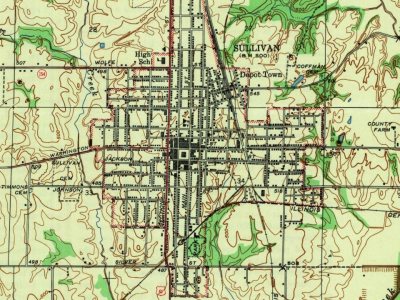
Fire insurance maps drew every building, what it was made of and what it was used for, so insurers could price the risk of fire. Pick a year, then a sheet.
On February 25, 1925, a mine in Sullivan exploded, which left 51 of the 122 miners dead. Another coal mine explosion followed in 1937, which killed 20.
On the night of March 31, 2023, Sullivan was struck by a large, powerful and deadly tornado as part of a much larger outbreak, causing catastrophic damage in the city and surrounding parts of the county. At least 3 people were confirmed dead and several others injured, while at least 200 structures sustained some sort of damage. The tornado was rated EF3, containing winds up to 165 mph (250 km/h).
Passages that mention Sullivan, cut from the printed page as they were published.
A history of the town of Sullivan, New Hampshire, 1777-19171921 · page 150Read the page →
Read the text
same to the town of Gilsum, Be it enacted by the Senate and Flouse of Representatives in General Court convened : Section i. That so much of the territory of the town of Sullivan as is described' and bounded as follows, to wit: beginning at the northwest corner of the town of Sullivan, thence south, 87 degrees east, seventy rods to a stake and stones on the east bank of the Ashuelot River, thence by the east and south bank of said river, eighty-seven rods, to a hemlock tree marked, on the west line
Text read by machine from the scan; it may contain errors.
A history of the town of Sullivan, New Hampshire, 1777-19171921 · page 160Read the page →
Read the text
It would be in place here to say a few words about John Sullivan for whom the town of Sullivan was named. For lack of space, however, we shall not repeat what was said by the author in his oration at the Sullivan Centennial.'* Since that oration was delivered, it has been discoveredt that the birthplace of John Sullivan was Somersworth, N. H., where his father was teaching and where his family were passing the winter. All the gazetteers and biographical dictionaries had
Text read by machine from the scan; it may contain errors.
History of Greene and Sullivan Counties, State of Indiana1884 · page 507Read the page →
Read the text
The first railroad built in Sullivan County was known by the above caption. It was begun in 1853 and completed in 1854, the first u through train ” passing Sullivan Saturday, November 25, 1854. For several months during the fall, there had been a gap from Sullivan to Carlisle, over which passengers were conveyed by stage. The completion of the road was joyously celebrated. The railroad company refused to carry the mail at the prices of the stage line, and mail continued to reach the county on the old Terre Haute & Vincennes route, which ex-
Text read by machine from the scan; it may contain errors.
History of Greene and Sullivan Counties, State of Indiana1884 · page 553Read the page →
Read the text
the night time and the inmates compelled to give up what money there was in their poesession; men were also stopped in public highways and forced to give up their money; houses, barns, grain and hay stacks were burned; the depot of the Evansville A Terre Haute Railroad at Sullivan was broken into and a large amount of goods were stolen therefrom; an express train on the same railroad was derailed between Sullivan and Paxton, and the express box stolen. Crimes of the character of these had become so frequent and daring that the people became alarmed. A
Text read by machine from the scan; it may contain errors.
Scans and text from the Internet Archive. Books published in 1930 or earlier, which are in the public domain.
Timeline
Sullivan, 1843 to 1943
Woven from the archive, old maps, post office records, the National Register and the people born here.
Nothing in the archives for these yearsWeddings on Main Street, storms, parades, school pictures, the old store. If it’s in your family album, it belongs here.
The Sullivan post office opened in 1843, the earliest record of the town by name (U.S. post office records).
How does Sullivan rank for history?
Sullivan is more historic than 95% of U.S. towns, #68 of 593 in Indiana. The History grade combines the town’s founding era, the share of homes built before 1940 and its National Register listings. It’s a character grade, so it isn’t part of the overall grade. How it works.
What is on the National Register in Sullivan?
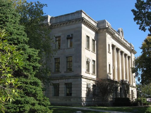
Three places: the Sherman Building (listed 1986), the Sullivan County Courthouse (2008) and the Sullivan Courthouse Square Historic District (2018).
How old are the homes in Sullivan?
33% of Sullivan’s homes were built before 1940 (Census estimate, ±7.1 points), against a typical 14% for an Indiana town; the median home was built in 1959.
Founding dates: Wikidata, Wikipedia, the U.S. post office records of Blevins & Helbock (CC0) and the Census. Homes by year built: Census ACS 2020–24. National Register of Historic Places: National Park Service (list of May 22, 2026). Old photos, postcards and papers: Wikimedia Commons, the Library of Congress and other public archives, credited on each item’s page. Maps: U.S. Geological Survey historical topographic maps (via Esri) and Sanborn fire-insurance maps (Library of Congress). History text and census tables: Wikipedia (CC BY-SA 4.0). Places that used to be: USGS Geographic Names Information System (2021).
From Wikimedia Commons (6), the National Register of Historic Places (3), Wikipedia, Wikidata and Wikipedia for famous people, U.S. Geological Survey historical maps, U.S. Census counts (via Wikipedia), the US Post Offices dataset (Blevins & Helbock), the USGS Geographic Names Information System, Sanborn fire insurance maps (Library of Congress) and old county and town histories (Internet Archive). Archive images are copied here with their credits and licenses, shown on each photo’s page. Refreshed monthly.




 2011
 2011
 2011
 2011


