St. John dates to 1837, and 1 of its places is on the National Register
More historic than 53% of U.S. towns · #365 of 593 in Indiana. What drives it
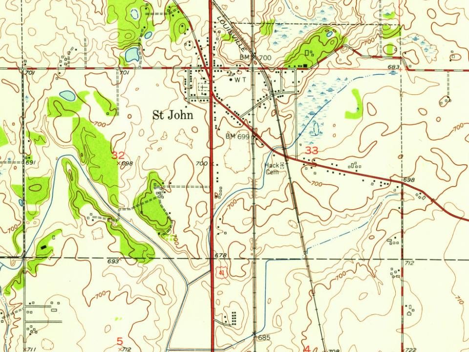
Most of St. John was built recently: 3% of its homes predate 1940 and the median home dates from 2003. Its Register listing is the Keilman, Francis P. House. Its Register listing is the Keilman, Francis P. House. Below: 1 old photo or paper, maps from 1953 on, and the census since 1880.
Founding year: Wikidata; Wikipedia’s history section gives the same year. First post office: 1846.The full story ↓
History grade
What drives St. John’s History grade
On its age, its old homes and the National Register, St. John is more historic than 53% of U.S. towns, #365 of 593 in Indiana. Its age holds the grade up; its share of homes from before 1940 pulls it down.
B−
HistoryA character grade: shown, never part of St. John’s overall grade.
Indiana towns list more on the Register than most of the country (a typical Indiana town has 7.9 per 10,000 residents, the U.S. 2.4), so St. John’s 1.3 sits near the middle of its state (47% of Indiana towns have fewer) while its 3 historic buildings outnumber those of 65% of U.S. towns.
How sure. Graded on any two of the three inputs instead, the letter would range from C to B+. The pre-1940 share (±1.5 points) is firm at this size. Two sources give 1837.
Founding year: Wikidata (other dates in Quick answers). Homes: Census ACS 2020–24. National Register: National Park Service, May 2026 list; each listing counted once (boundary changes and added documentation belong to their listing), and a historic district counts its contributing buildings. How TownRatings grades history →
What stands out about St. John’s past
Read from the archive, the National Register and the record. The page puts what stands out first.
The St. John post office was established in 1846. The community took its name from Saint Johns Church. The Church was the first church in Lake County and was founded by German immigrant John Hack.
St. John is home to the Shrine of Christ's Passion, opened in 2008. An interactive display of the Passion of Christ, it contains 40 life-size statues depicting the time from the Agony in the Garden all the way to the Resurrection. It has attracted visitors from all 50 US states and more than 40 countries.
The Francis P. Keilman House was listed in the National Register of Historic Places in 2013.
Passages that mention St. John, cut from the printed page as they were published.
The river St. John, its physical features, legends and history, from 1604 to 17841910 · page 384Read the page →
Read the text
The peninsula south of this street, which now contains the business part of the city of St. John, and which was laid out for the Loyalists in 1783 as Parr-town, was not included in the grant. The primary object of the grantees was evidently the limestone quarries and the big marsh, and they probably deemed the land south of Union Street hardly worth the quit rents.
Text read by machine from the scan; it may contain errors.
The river St. John, its physical features, legends and history, from 1604 to 17841910 · page 270Read the page →
Read the text
James Simonds may be considered the founder of the first permanent settlement at the mouth of the River Saint John. The attention of Mr. Simonds may have been particularly directed to St. John by the fact that his relative, Captain Moses Hazen, was stationed there in the Fort Frederick garrison in 1759. A few years ago the writer of this book had the good fortune to discover in a rubbish heap a letter in which James Simonds
Text read by machine from the scan; it may contain errors.
Scans and text from the Internet Archive. Books published in 1930 or earlier, which are in the public domain.
In 1837, according to Wikidata and Wikipedia’s history of the town. St. John’s post office opened in 1846, and the census of 1880 counted 40 people here.
How does St. John rank for history?
St. John is more historic than 53% of U.S. towns, #365 of 593 in Indiana. The History grade combines the town’s founding era, the share of homes built before 1940 and its National Register listings. It’s a character grade, so it isn’t part of the overall grade. How it works.
What is on the National Register in St. John?
One place: the Keilman, Francis P. House (listed 2013).
How old are the homes in St. John?
3% of St. John’s homes were built before 1940 (Census estimate, ±1.5 points), against a typical 14% for an Indiana town; the median home was built in 2003.
Founding dates: Wikidata, Wikipedia, the U.S. post office records of Blevins & Helbock (CC0) and the Census. Homes by year built: Census ACS 2020–24. National Register of Historic Places: National Park Service (list of May 22, 2026). Old photos, postcards and papers: Wikimedia Commons, the Library of Congress and other public archives, credited on each item’s page. Maps: U.S. Geological Survey historical topographic maps (via Esri) and Sanborn fire-insurance maps (Library of Congress). History text and census tables: Wikipedia (CC BY-SA 4.0). Places that used to be: USGS Geographic Names Information System (2021).
From Wikimedia Commons (9), Wikidata (1), the National Register of Historic Places (1), Wikipedia, Wikidata and Wikipedia for famous people, U.S. Geological Survey historical maps, U.S. Census counts (via Wikipedia), the US Post Offices dataset (Blevins & Helbock), the USGS Geographic Names Information System and old county and town histories (Internet Archive). Archive images are copied here with their credits and licenses, shown on each photo’s page. Refreshed monthly.



 Date?
 2025
 2025
 2025
 2015
 2013
 2011
 2008
 2006