Roann’s post office opened in 1866, and 42% of its homes were built before 1940
3 places in town are on the National Register, among them a historic district with 117 buildings. Below: 1 old photo or paper, maps from 1901 on, and the census since 1880.
There are two theories on how the town of Roann got its name. One source claims that the community was named for Roanne, France. Another tells a legend about how a father saw his daughter on a boat in a dangerous current and was shouting at her "Row, Ann!"
The Thomas J. Lewis House, Roann Covered Bridge, Roann Historic District, and Roann-Paw Paw Township Public Library are listed on the National Register of Historic Places.
Passages that mention Roann, cut from the printed page as they were published.
History of Wabash County Indiana (Volume 2)1914 · page 716Read the page →
Read the text
hundred and seventy-three acres. Mr. Schuler and his brother have added to the area of the old homestead, and John Schuler now has fortythree acres of his own adjoining the old place. In 1900 Mr. Schuler moved into the village of Roann, and engaged actively in business with his son Robert. In 1898 they had bought the undertaking and furniture store at Roann from Colt & Oswald, which during the following year was conducted under the firm name of Lowman & Schuler. Then Ed Case bought the Lowman interest, and after running for a year as
Text read by machine from the scan; it may contain errors.
History of Wabash County Indiana (Volume 2)1914 · page 675Read the page →
Read the text
+ G. P. Kidd, M. D. In the village of Roann and vicinity Dr. Kidd has for nearly forty years filled the place of family physician to the families of that locality. That is the most responsible, the most honor¬ able, the most intimate relation man can hold to his fellowman. His has.
Text read by machine from the scan; it may contain errors.
Roann 's Pine School The towiLship school at Roann is a large brick building, two stories and basement, and is a credit to the citizens and supporters of the system. The main structure was erected in 1900 on the site of the schoolhouse destroyed by fire. In September, 1914, a large addition was completed at a cost of $13,000, making the school building as a whole one of the most complete and modern in the county. There are about sixty pupils 111 the high school department and 175 in the grammar grades.
Text read by machine from the scan; it may contain errors.
Scans and text from the Internet Archive. Books published in 1930 or earlier, which are in the public domain.
Timeline
Roann, 1866 to 1969
Woven from the archive, old maps, post office records, the National Register and the people born here.
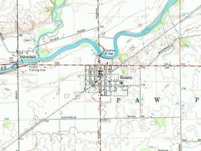
U.S. Geological Survey historical topographic maps (public domain), via Esri’s collection of the scans. The red ring marks the center of Roann.
Every building
Roann, building by building, 1901–1920
Fire insurance maps drew every building, what it was made of and what it was used for, so insurers could price the risk of fire. Pick a year, then a sheet.
1901Sheet 1 of 1
Edition
Sheets
BrickWoodStone
Sanborn Map Company, via the Library of Congress. Editions published in 1930 or earlier, which are in the public domain.
Then & now
Stand where they stood
No then-and-now pairs yet. Take a photo from the same spot as an old one and they appear here side by side.
Retake this viewRoann-indiana-from-above
Find the spot, match the angle, and add your photo. It becomes the first then-and-now pair on Roann’s page.
Founding dates: Wikidata, Wikipedia, the U.S. post office records of Blevins & Helbock (CC0) and the Census. Homes by year built: Census ACS 2020–24. National Register of Historic Places: National Park Service (list of May 22, 2026). Old photos, postcards and papers: Wikimedia Commons, the Library of Congress and other public archives, credited on each item’s page. Maps: U.S. Geological Survey historical topographic maps (via Esri) and Sanborn fire-insurance maps (Library of Congress). History text and census tables: Wikipedia (CC BY-SA 4.0). Places that used to be: USGS Geographic Names Information System (2021). How TownRatings grades history →
From Wikimedia Commons (4), Wikidata (2), the National Register of Historic Places (3), Wikipedia, Wikidata and Wikipedia for famous people, U.S. Geological Survey historical maps, U.S. Census counts (via Wikipedia), the US Post Offices dataset (Blevins & Helbock), the USGS Geographic Names Information System, Sanborn fire insurance maps (Library of Congress) and old county and town histories (Internet Archive). Archive images are copied here with their credits and licenses, shown on each photo’s page. Refreshed monthly.



 Date?
 2016
 2014
 2013

