Founding year: Wikipedia. First post office: 1843.The full story ↓
History grade
What drives Hebron’s History grade
On its age, its old homes and the National Register, Hebron is more historic than 72% of U.S. towns, #280 of 593 in Indiana. Its age holds the grade up; its National Register listings pull it down.
B+
HistoryA character grade: shown, never part of Hebron’s overall grade.
Indiana towns list more on the Register than most of the country (a typical Indiana town has 7.9 per 10,000 residents, the U.S. 2.4), so Hebron’s 2.5 sits near the middle of its state (49% of Indiana towns have fewer) while its 1 listings outnumber those of 51% of U.S. towns.
How sure. Graded on any two of the three inputs instead, the letter would range from B to A−. The pre-1940 share is a Census survey estimate (±8.5 points). Two sources give 1841.
Founding year: Wikipedia (other dates in Quick answers). Homes: Census ACS 2020–24. National Register: National Park Service, May 2026 list; each listing counted once (boundary changes and added documentation belong to their listing), and a historic district counts its contributing buildings. How TownRatings grades history →
What stands out about Hebron’s past
Read from the archive, the National Register and the record. The page puts what stands out first.
The first settler to Hebron was Judge Jesse Johnson (1st Judge of the Porter County Probate Court. The area of Hebron was an open prairie interspersed with small groves of trees. The prairie was about 2.5 miles (4.0 km) long by 0.75 miles (1.21 km) wide. About 0.5 miles (0.80 km) south was the Potawatomi village of Hauakiki. Locally the village was called "Indian Town."
Passages that mention Hebron, cut from the printed page as they were published.
Annals of Oxford, Maine, from its incorporation, February 27, 1829 to 1850. Prefaced by a brief account of the settlement of Shepardsfield plantation, now Hebron and Oxford, and supplemented with genealogical notes from the earliest records of both towns1903 · page 33Read the page →
Read the text
Sec. 2. Be it further enacted, That said town of Oxford shall pay to said town of Hebron the arrears of all taxes which have been legally assessed together with their proportion of all debts due from and assessments which may have been voted by said town of Hebron, at the time of the passing of this Act ; such proportion to be ascertained by reference to the last valuation of said town of Hebron.
Text read by machine from the scan; it may contain errors.
Annals of Oxford, Maine, from its incorporation, February 27, 1829 to 1850. Prefaced by a brief account of the settlement of Shepardsfield plantation, now Hebron and Oxford, and supplemented with genealogical notes from the earliest records of both towns1903 · page 32Read the page →
Read the text
We, the subscribers, a committee for and in behalf of the town of Hebron, represent that the local situation of the town of Hebron is such as to disommode the inhabitants in transacting their business, by reason of its great length, and no convenient center, wherefore your Petioners pray that said town of Hebron may be divided by Mattews pond and streams so called agreeable to a vote of said town in a legal meeting for that purpose, held the 22d day of Dec. 1828.
Text read by machine from the scan; it may contain errors.
ganized in July, 1838, by a minister named Hannan, and after a few years the old school house was abandoned and the churcii building used for school purposes. In 1840 a second school house was built about a mile and a half southwest of the present town of Hebron. It was also a log structure, about 18 by 20 feet in size. The third school hou.se in the township was built on the northeast corner of section 15, township 33, range 7, in 1842, and Mary Grossman was the first teacher. Two years later the building was burned. Some of the early teachers were Ellen
Text read by machine from the scan; it may contain errors.
Pittsburg, Cincinnati, Chicago & St. Louis Uailroad Company, which operates a double track line through tlie township, entering on the east two miles south of the northern Ijoundary mid running due west to Hebron, where it turns northwest and eiosses the west line of the county one mile north of Hebron. Aylesworth is a flag station on this road, four miles east of Hebron, and with the exception of a small portion of the southwest corner, no part of the township is more than three miles from the railroad. There are over twenty miles of macadamized road
Text read by machine from the scan; it may contain errors.
Scans and text from the Internet Archive. Books published in 1930 or earlier, which are in the public domain.
By decade
Hebron, decade by decade
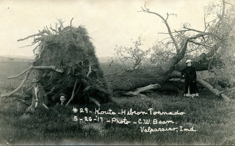
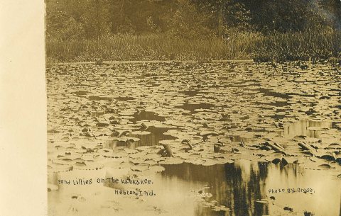
One decade in the archive so far: the 1910s. Scroll each row; tap a photo for its story.
Nothing in the archives for these yearsWeddings on Main Street, storms, parades, school pictures, the old store. If it’s in your family album, it belongs here.
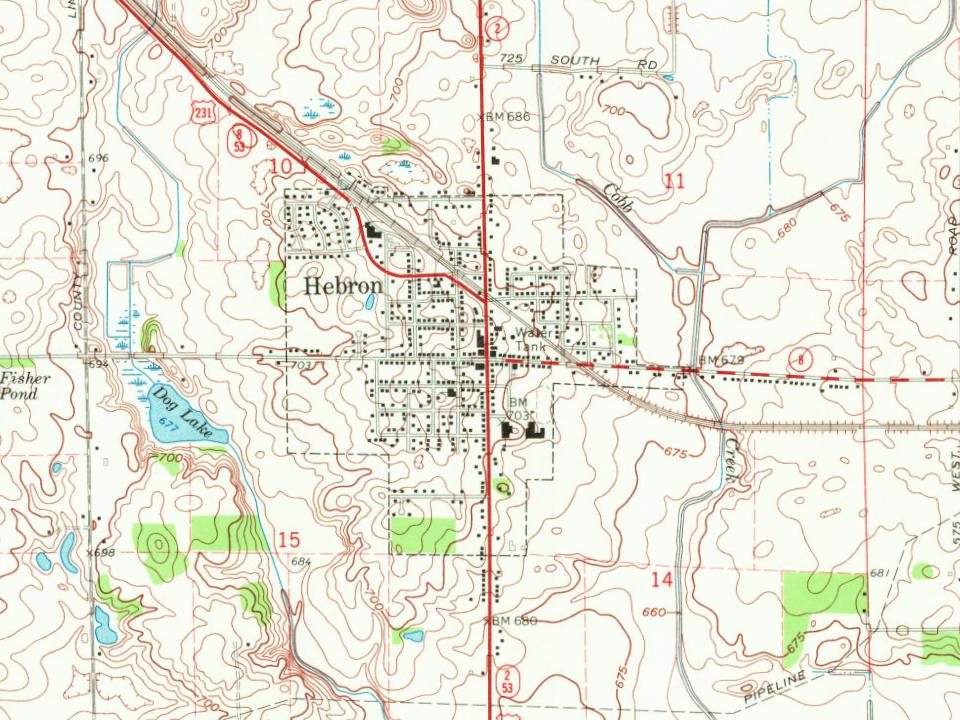
Every edition of the U.S. Geological Survey’s map of Hebron. Tap a year, or press play to watch the town change.
1953Hebron sheet · 1:24,000
U.S. Geological Survey historical topographic maps (public domain), via Esri’s collection of the scans. The red ring marks the center of Hebron.
Every building
Hebron, building by building, 1895–1909
Fire insurance maps drew every building, what it was made of and what it was used for, so insurers could price the risk of fire. Pick a year, then a sheet.
1895Sheet 1 of 1
Edition
Sheets
BrickWoodStone
Sanborn Map Company, via the Library of Congress. Editions published in 1930 or earlier, which are in the public domain.
Then & now
Stand where they stood
No then-and-now pairs yet. Take a photo from the same spot as an old one and they appear here side by side.
Retake this viewGrand Opera House Fire, September 16, 1912 - Hebron, Indiana - Flickr - Shook Photos, 1912
Find the spot, match the angle, and add your photo. It becomes the first then-and-now pair on Hebron’s page.
US Post Offices dataset (Blevins & Helbock, CC0). Places and cemeteries from the USGS Geographic Names Information System (2021).
Questions about Hebron’s history
What year was Hebron founded?
In 1841, according to Wikipedia’s history of the town. Hebron’s post office opened in 1843, and the census of 1880 counted 715 people here.
How does Hebron rank for history?
Hebron is more historic than 72% of U.S. towns, #280 of 593 in Indiana. The History grade combines the town’s founding era, the share of homes built before 1940 and its National Register listings. It’s a character grade, so it isn’t part of the overall grade. How it works.
What is on the National Register in Hebron?
One place: the Eli Sigler House (listed 2011).
How old are the homes in Hebron?
17% of Hebron’s homes were built before 1940 (Census estimate, ±8.5 points), against a typical 14% for an Indiana town; the median home was built in 1976.
Founding dates: Wikidata, Wikipedia, the U.S. post office records of Blevins & Helbock (CC0) and the Census. Homes by year built: Census ACS 2020–24. National Register of Historic Places: National Park Service (list of May 22, 2026). Old photos, postcards and papers: Wikimedia Commons, the Library of Congress and other public archives, credited on each item’s page. Maps: U.S. Geological Survey historical topographic maps (via Esri) and Sanborn fire-insurance maps (Library of Congress). History text and census tables: Wikipedia (CC BY-SA 4.0). Places that used to be: USGS Geographic Names Information System (2021).
From Wikimedia Commons (35), the National Register of Historic Places (1), Wikipedia, Wikidata and Wikipedia for famous people, U.S. Geological Survey historical maps, U.S. Census counts (via Wikipedia), the US Post Offices dataset (Blevins & Helbock), the USGS Geographic Names Information System, Sanborn fire insurance maps (Library of Congress) and old county and town histories (Internet Archive). Archive images are copied here with their credits and licenses, shown on each photo’s page. Refreshed monthly.




 2009
 2009
 2009
 2009
 2009
 2009
 2009
 2009
 2009
 2009
 2009
 2009
 2009
 2009
 2009
 2009
 2009
 2009
 2009
 2009
 2008
 2008
 2007
 2007
 2007
 2007
 2007
 2007
 2007
 2007
 2006
 2006
 2006
 2003