Clinton’s post office opened in 1823, and 46% of its homes were built before 1940
More historic than 96% of U.S. towns · #54 of 593 in Indiana. What drives it
2 places in town are on the National Register, among them a historic district with 46 buildings. Below: 29 old photos and papers, maps from 1886 on, and the census since 1850.
Founding year: the first Clinton post office (Blevins & Helbock, CC0). Wikidata: 1829.The full story ↓
History grade
What drives Clinton’s History grade
On its age, its old homes and the National Register, Clinton is more historic than 96% of U.S. towns, #54 of 593 in Indiana. All 3 inputs are above most U.S. towns; its share of homes from before 1940 ranks highest and its age lowest.
A+
HistoryA character grade: shown, never part of Clinton’s overall grade.
Indiana towns list more on the Register than most of the country (a typical Indiana town has 7.9 per 10,000 residents, the U.S. 2.4), so Clinton’s 98.0 sits above most of its state (81% of Indiana towns have fewer) while its 47 historic buildings outnumber those of 84% of U.S. towns.
How sure. Graded on any two of the three inputs instead, the letter would range from A to A+. The pre-1940 share is a Census survey estimate (±7.9 points). The founding year is the first post office, not a stated founding date; Wikidata’s 1829 falls in the same era, so the grade doesn’t depend on which one is used.
Founding year: the first post office (other dates in Quick answers). Homes: Census ACS 2020–24. National Register: National Park Service, May 2026 list; each listing counted once (boundary changes and added documentation belong to their listing), and a historic district counts its contributing buildings. How TownRatings grades history →
What stands out about Clinton’s past
Read from the archive, the National Register and the record. The page puts what stands out first.
Nothing in the archives for these yearsWeddings on Main Street, storms, parades, school pictures, the old store. If it’s in your family album, it belongs here.
Fire insurance maps drew every building, what it was made of and what it was used for, so insurers could price the risk of fire. Pick a year, then a sheet.
1886Sheet 1 of 1
Edition
Sheets
BrickWoodStone
Sanborn Map Company, via the Library of Congress. Editions published in 1930 or earlier, which are in the public domain.
On the National Register
2 listings protect 47 historic buildings
The country’s official list of buildings and places worth saving.
The city was established in 1829 and is named for DeWitt Clinton, governor of New York from 1817 to 1823. Many of Clinton's original settlers were immigrants working in coal mines, many from Italy. According to Vermillion County naturalization records, "...from 1856 to 1952... Vermillion County received almost 3,550 new citizens of foreign birth, the largest number coming during the first twelve years of [the 20th] century. Italians accounted for one-third, or 1,178, of the total number who filed Declarations, with Austrians the next largest group (675) and then Scots. At least 77 percent of the Italians were from the northern regions of Italy." This was in contrast to the majority of Italian immigrants to America during this same time period that hailed from southern Italy. Over time, the coal mining industry in Clinton ended but many of the Italian settlers stayed at Clinton.
Passages that mention Clinton, cut from the printed page as they were published.
History of Clinton and Franklin Counties, New York1880 · page 276Read the page →
Read the text
This town lies on Lake Champlain, in the northeast section of Clinton County, and is bounded on the north by the town of Champlain, in the same county, on the south by the town of Beekmantown, also in Clinton County, on the east by Lake Champlain, and on the west by the town of Altona, Clinton County. It comprehends an area of 52 square miles, and the population, as given in the census of 1875, is 3068. A United States lighthouse stands on
Text read by machine from the scan; it may contain errors.
History of Clinton and Franklin Counties, New York1880 · page 302Read the page →
Read the text
The parish includes stations at Ellenburgh, Forest (in Altona), and at Clinton Mills. At the former point is a neat house of worship belonging to the denomination. The number of families in the parish is estimated at 300 at Clinton, 400 at Ellenburgh, and 12 at Forest. At Churubusco a fine brick parsonage was erected in 1878, and a barn in 1879. The cemetery belonging to the denomination at Churubusco was laid out soon after the organization
Text read by machine from the scan; it may contain errors.
History of Centre and Clinton Counties, Pennsylvania1883 · page 169Read the page →
Read the text
valleys. This was the era of borough, county, and township subscriptions, and the year in which that form of improvement mania reached its crisis in time to save the counties of Clinton, Centre, and Blair from a heavy railroad subscription debt. The demands for this method of transportation being such that they could no longer be baffled, and the charter of 1853 not being elastic enough, the passage of the
Text read by machine from the scan; it may contain errors.
Scans and text from the Internet Archive. Books published in 1930 or earlier, which are in the public domain.
Timeline
Clinton, 1823 to 1952
Woven from the archive, old maps, post office records, the National Register and the people born here.
The Clinton post office opened in 1823, the earliest record of the town by name (U.S. post office records). Wikidata gives 1829.
How does Clinton rank for history?
Clinton is more historic than 96% of U.S. towns, #54 of 593 in Indiana. The History grade combines the town’s founding era, the share of homes built before 1940 and its National Register listings. It’s a character grade, so it isn’t part of the overall grade. How it works.
What is on the National Register in Clinton?
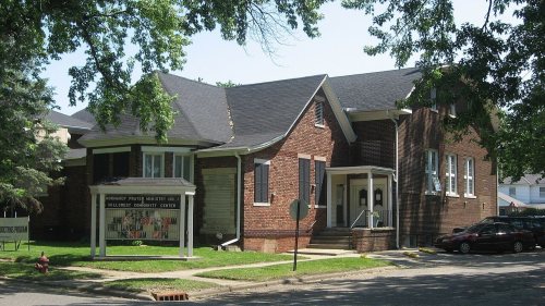
Two places: the Hill Crest Community Center (listed 1997) and the Clinton Downtown Historic District (2000).
How old are the homes in Clinton?
46% of Clinton’s homes were built before 1940 (Census estimate, ±7.9 points), against a typical 14% for an Indiana town; the median home was built in 1943.
Founding dates: Wikidata, Wikipedia, the U.S. post office records of Blevins & Helbock (CC0) and the Census. Homes by year built: Census ACS 2020–24. National Register of Historic Places: National Park Service (list of May 22, 2026). Old photos, postcards and papers: Wikimedia Commons, the Library of Congress and other public archives, credited on each item’s page. Maps: U.S. Geological Survey historical topographic maps (via Esri) and Sanborn fire-insurance maps (Library of Congress). History text and census tables: Wikipedia (CC BY-SA 4.0). Places that used to be: USGS Geographic Names Information System (2021).
From Wikimedia Commons (26), the Library of Congress (3), Wikidata (1), the National Register of Historic Places (2), Wikipedia, Wikidata and Wikipedia for famous people, U.S. Geological Survey historical maps, U.S. Census counts (via Wikipedia), the US Post Offices dataset (Blevins & Helbock), the USGS Geographic Names Information System, Sanborn fire insurance maps (Library of Congress) and old county and town histories (Internet Archive). Archive images are copied here with their credits and licenses, shown on each photo’s page. Refreshed monthly.


 1908
 1908
 1908
 1908
 1908
 1908
 1908
 1908
 1908
 1908
 1908
 1908
 1908
 1908
 1908
 1908
 1908
 1908
 1908
 1908
 1908
 1908
 1909
 1913
 1921
 1921
 1940
 1940
 1940