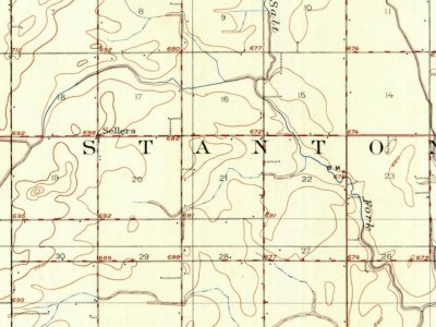
Every edition of the U.S. Geological Survey’s map of Stanton Township. Tap a year, or press play to watch the town change.
1906Urbana sheet · 1:62,500
U.S. Geological Survey historical topographic maps (public domain), via Esri’s collection of the scans. The red ring marks the center of Stanton Township.
Stanton Township formed from a portion of St. Joseph Township on an unknown date. The first settler in the township was called Samuel McClughen, who came from Ohio in 1834.
Passages that mention Stanton Township, cut from the printed page as they were published.
A Standard history of Champaign County Illinois1918 · page 891Read the page →
Read the text
When Mr. Phenicie came to Stanton Township there was not a public road, schoolhouse nor church in the entire community, and his own efforts and influence have co-operated with every movement for such improvement and advancement. Since the death of his good wife Mr. Phenicie has continued to live on the home farm, but has surrendered the responsibilities of its management to his capable son Otis, and in his cultured daughter-in-law finds a most capable home maker.
Text read by machine from the scan; it may contain errors.
Scans and text from the Internet Archive. Books published in 1930 or earlier, which are in the public domain.
Timeline
Stanton Township, 1890 to 1906
Woven from the archive, old maps, post office records, the National Register and the people born here.
Founding dates: Wikidata, Wikipedia, the U.S. post office records of Blevins & Helbock (CC0) and the Census. Homes by year built: Census ACS 2020–24. National Register of Historic Places: National Park Service (list of May 22, 2026). Old photos, postcards and papers: Wikimedia Commons, the Library of Congress and other public archives, credited on each item’s page. Maps: U.S. Geological Survey historical topographic maps (via Esri) and Sanborn fire-insurance maps (Library of Congress). History text and census tables: Wikipedia (CC BY-SA 4.0). Places that used to be: USGS Geographic Names Information System (2021). How TownRatings grades history →
From Wikipedia, U.S. Geological Survey historical maps, the US Post Offices dataset (Blevins & Helbock), the USGS Geographic Names Information System and old county and town histories (Internet Archive). Archive images are copied here with their credits and licenses, shown on each photo’s page. Refreshed monthly.